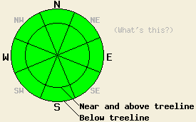
This Avalanche Advisory was published on January 6, 2011:

|
January 6, 2011 at 8:00 am |
|
On all aspects and at all elevations, the avalanche danger will remain LOW today. Even though dangerous avalanche activity should remain unlikely, it is not impossible. Continue to use normal caution when traveling in the backcountry. |
|
|
|
Forecast Discussion:
Another sunny, mild day for the forecast area as a high pressure ridge remains over the region. Temperatures should climb into the high 30's and low 40's today above 7000 ft, and the light easterly winds should continue. The inversion keeping the valleys colder than the mountains should also persist today. By this afternoon some thin, high clouds should push into the area as a result of a dry low pressure off the CA coast. These clouds should continue through tomorrow.
Observations near Relay Peak (Mt. Rose area) and on Angora Peak (Echo Summit area) showed significant settlement and consolidation in the snowpack. Hand pits, layer bonding tests, and ski cuts on steep test slopes showed stable results in these areas. Ski cuts on a few 40-45 degree slopes in the Angora Peak area did produce small, shallow sluffs that moved a short distance down the slope. The sheltered slopes in both of these areas still hold several inches of cold, soft snow on the surface. This soft snow existed on most N-NE aspects almost up to the ridgelines on Angora Peak. On the most exposed slopes near the highest ridgelines on Angora Peak, the east winds had created a firm wind scoured surface. On Relay Peak the east winds had more of an affect leaving a mix of firm wind scoured surfaces and wind created textures on exposed N-NE-E aspects near and above treeline (photo). On the more sun-exposed aspects on the southerly half of the compass, the sun created a variety of breakable and supportable crusts in both of these areas.
Avalanche Concerns:
As the snowpack gains strength due to settlement and consolidation, avalanches become more and more unlikely. The mild weather, light winds, weak winter sun, and short days will allow this strengthening trend to continue . Avalanche activity will remain unlikely today. Unlikely does not mean impossible. Some small isolated pockets of unstable snow could still lurk on isolated terrain features like very steep unsupported snowfields. Continue to travel with caution and evaluate slopes carefully.
Small roller balls and small wet, loose snow sluffs may continue to occur today due to daytime warming. These should remain very small and not entrain enough snow to snow to bury a person or pose much of a threat to people . They should remain limited to isolated areas on sun-exposed aspects on the southerly half of the compass.
The bottom line:
On all aspects and at all elevations, the avalanche danger will remain LOW today. Even though dangerous avalanche activity should remain unlikely, it is not impossible. Continue to use normal caution when traveling in the backcountry.
Weather Observations from along the Sierra Crest between 8200 ft and 8800 ft:
| 0600 temperature: | 27-34 deg. F. |
| Max. temperature in the last 24 hours: | 34-44 deg. F. |
| Average wind direction during the last 24 hours: | East |
| Average wind speed during the last 24 hours: | 15 mph |
| Maximum wind gust in the last 24 hours: | 36 mph |
| New snowfall in the last 24 hours: | O inches |
| Total snow depth: | 73-103 inches |
Two-Day Mountain Weather Forecast - Produced in partnership with the Reno NWS
For 7000-8000 ft: |
|||
| Thursday: | Thursday Night: | Friday: | |
| Weather: | Sunny this morning becoming partly cloudy this afternoon | Partly cloudy | Partly cloudy |
| Temperatures: | 39-45 deg. F. | 14-24 deg. F. | 38-44 deg. F. |
| Wind direction: | Southeast shifting to the east | East | North |
| Wind speed: | Light | up to 10 mph | up to 10 mph |
| Expected snowfall: | O in. | O in. | O in. |
For 8000-9000 ft: |
|||
| Thursday: | Thursday Night: | Friday: | |
| Weather: | Sunny this morning becoming partly cloudy this afternoon | Partly cloudy | Partly cloudy |
| Temperatures: | 36-43 deg. F. | 19-27 deg. F. | 35-42 deg. F. |
| Wind direction: | Southeast shifting to the east | East | North |
| Wind speed: | 10-15 mph | 10-15 mph | 10-15 mph |
| Expected snowfall: | O in. | O in. | O in. |


