In partnership with: 
|
January 7, 2011 at 7:48 am |
|
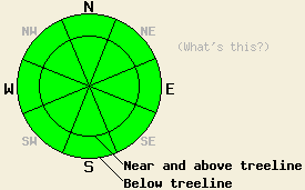
Avalanche danger is LOW for all elevations and aspects. Normal caution is advised. |
|
|
|
Another warm and sunny day is in store for the forecast area today. A strong air temperature inversion remains in place with air temperatures at many locations above 7,000' remaining above freezing overnight. Further warming of air temperatures today will allow for daytime highs well into the 40s for areas above 7,000'. Colder air will remain trapped in the valleys below 7,000'. Today will be the warmest day of this high pressure period. Ridgetop winds remain light to moderate in speed out of the east to northeast this morning. Light to moderate speed northeast winds are forecast to continue today before shifting to the west overnight ahead of an approaching cold front.
Observations made yesterday on Lincoln Ridge (Yuba Pass area), on Donner Pass (Donner Summit area), and on Meiss Ridge (Carson Pass area) matched well with other recent observations from around the forecast area indicating a widespread stable snowpack. Despite above freezing air temperatures, snow surface conditions on wind sheltered northerly aspects remain cold and unconsolidated due to the low sun angles and minimal solar radiation this time of year. Areas more exposed to east and north winds have seen some amount of wind scouring and wind crust formation that ranges from supportable to breakable to hardly noticeable. Southerly aspects are undergoing minimal melt freeze conditions with thin sun crusts forming in some but not all areas of direct sun exposure.
Avalanche Concerns:
Recent observations have indicated that widespread stable snowpack conditions exist. Keep in mind that some degree of spacial variability is always present. Very isolated areas of instability are unlikely, but certainly not impossible. If any human triggered avalanche activity occurs today it will be very isolated, occur within the recent storm snow, and likely take the triggering individual by surprise. Exercise good travel habits and maintain respect for N-NE aspect micro terrain features, especially within greater areas of steep and complex or extreme terrain.
On southerly aspects, some roller ball activity may occur today due to daytime warming. Low sun angle and minimal incoming solar radiation will keep snow surface warming on southerly aspects to a minimum. This is not expected to present a hazard to backcountry travelers today.
| 0600 temperature: | 22 to 37 deg. F. |
| Max. temperature in the last 24 hours: | 39 to 50 deg. F. |
| Average wind direction during the last 24 hours: | East |
| Average wind speed during the last 24 hours: | 12 mph |
| Maximum wind gust in the last 24 hours: | 25 mph |
| New snowfall in the last 24 hours: | O inches |
| Total snow depth: | 72 to 102 inches |
For 7000-8000 ft: |
|||
| Friday: | Friday Night: | Saturday: | |
| Weather: | Mostly sunny skies. | Partly cloudy skies. | Mostly cloudy skies. |
| Temperatures: | 45 to 50 deg. F. | 24 to 32 deg. F. | 38 to 44 deg. F. |
| Wind direction: | NE | N shifting to W after midnight. | SW |
| Wind speed: | 5 to 15 mph | Around 10 mph. | Around 10 mph. |
| Expected snowfall: | O in. | O in. | O in. |
For 8000-9000 ft: |
|||
| Friday: | Friday Night: | Saturday: | |
| Weather: | Mostly sunny skies. | Partly cloudy skies. | Mostly cloudy skies. |
| Temperatures: | 42 to 48 deg. F. | 24 to 31 deg. F. | 34 to 40 deg. F. |
| Wind direction: | NE | N shifting to W after midnight. | W |
| Wind speed: | 10 to 20 mph | 10 to 20 mph with gusts to 30 mph after midnight. | 10 to 20 mph with gusts to 35 mph. |
| Expected snowfall: | O in. | O in. | O in. |


This website is owned and maintained by the non-profit arm of the Sierra Avalanche Center. Some of the content is updated by the USDA avalanche forecasters including the forecasts and some observational data. The USDA is not responsible for any advertising, fund-raising events/information, or sponsorship information, or other content not related to the forecasts and the data pertaining to the forecasts.

