In partnership with: 
|
January 8, 2011 at 7:40 am |
|
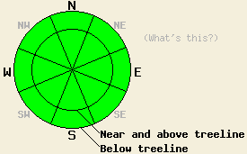
Avalanche danger is LOW for all elevations and aspects. Normal caution is advised. |
|
|
|
One more day of above freezing air temperatures will occur today before a cold front passes through the region tonight. After a brief period of sunshine early this morning, a thick layer of mid and high level clouds will move into the forecast area. An air temperature inversion remains in place across the region this morning. Temperatures remained near or above freezing overnight in most locations above 7,000'. Below 7,000', air temperatures are in the teens and 20s. In the Carson Pass area, the inversion boundary is significantly higher, likely near 8,500' to 9,000'. Ridgetop winds shifted to the west overnight and are light to moderate in speed this morning. As west winds increase to moderate in speed today, warmer air will mix down into the lower elevations bringing air temperatures there above freezing. Cold front passage tonight is expected to cool air temperatures above 7,000' into the teens and 20s for tonight and Sunday.
Observations made yesterday on Silver Peak (Pole Creek area) did not reveal any evidence of instability (pit profile, more info). This matched well with other recent observations from around the forecast area indicating a widespread stable snowpack. Despite above freezing air temperatures, snow surface conditions on wind sheltered northerly aspects remain cold and unconsolidated due to the low sun angles and minimal solar radiation this time of year. Areas more exposed to east and north winds have seen some amount of wind scouring and wind crust formation that ranges from supportable to breakable to hardly noticeable. Southerly aspects are undergoing minimal melt freeze conditions with thin sun crusts forming in some but not all areas of direct sun exposure.
Avalanche Concerns:
Recent observations have indicated that widespread stable snowpack conditions exist. Keep in mind that some degree of spacial variability is always present. Very isolated areas of instability are unlikely, but certainly not impossible. If any human triggered avalanche activity occurs today it will be very isolated, occur within the recent storm snow, and likely take the triggering individual by surprise. Exercise good travel habits and maintain respect for N-NE aspect micro terrain features, especially within greater areas of steep and complex or extreme terrain.
Increasing west winds today are forecast to become strong enough at times to move snow. A small amount of wind loading my occur near and above treeline in lee areas, mainly on NE-E aspects. Any fresh slabs or pillows of transported snow that form today are expected to be very small and not present a significant hazard to backcountry travelers.
| 0600 temperature: | 23 to 32 deg. F. |
| Max. temperature in the last 24 hours: | 41 to 48 deg. F. |
| Average wind direction during the last 24 hours: | East shifting to west |
| Average wind speed during the last 24 hours: | 12 mph |
| Maximum wind gust in the last 24 hours: | 25 mph |
| New snowfall in the last 24 hours: | O inches |
| Total snow depth: | 71 to 100 inches |
For 7000-8000 ft: |
|||
| Saturday: | Saturday Night: | Sunday: | |
| Weather: | Mostly cloudy skies. | Occasional high clouds. | Occasional high clouds. |
| Temperatures: | 38 to 43 deg. F. | 16 to 21 deg. F. | 24 to 29 deg. F. |
| Wind direction: | W | W | N |
| Wind speed: | 5 to 10 mph in the morning increasing to 10 to 20 mph in the afternoon. | 10 to 20 mph with gusts to 30 mph. | 10 to 15 mph. |
| Expected snowfall: | O in. | O in. | O in. |
For 8000-9000 ft: |
|||
| Saturday: | Saturday Night: | Sunday: | |
| Weather: | Mostly cloudy skies. | Occasional high clouds. | Occasional high clouds. |
| Temperatures: | 35 to 41 deg. F. | 14 to 19 deg. F. | 20 to 25 deg. F. |
| Wind direction: | W | W | NW |
| Wind speed: | 15 to 25 mph with gusts to 40 mph. | 15 to 25 mph with gusts to 40 mph. | 10 to 20 mph with gusts to 35 mph. |
| Expected snowfall: | O in. | O in. | O in. |


This website is owned and maintained by the non-profit arm of the Sierra Avalanche Center. Some of the content is updated by the USDA avalanche forecasters including the forecasts and some observational data. The USDA is not responsible for any advertising, fund-raising events/information, or sponsorship information, or other content not related to the forecasts and the data pertaining to the forecasts.

