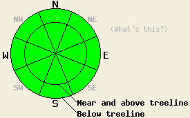
This Avalanche Advisory was published on January 10, 2011:

|
January 10, 2011 at 8:01 am |
|
The avalanche danger will remain LOW for all elevations and aspects today. Continue to use normal caution when travelling in the backcountry. |
|
|
|
Forecast Discussion:
The forecast calls for another cold day across the region with daytime highs in the low 20's. The light east winds have returned to the forecast area as yesterday's cold front continues eastward. Another weak low pressure system approaching the area should start to bring some clouds into the Sierra today. These clouds should increase tonight and tomorrow as this system arrives. Temperatures should also increase as this system pulls some warmer air into the area. By tomorrow a 30% chance of snow showers creeps back into the forecast; however, very little accumulation is expected.
Yesterday's westerly winds did transport some snow onto the N-NE-E aspects near ridgelines in the Carpenter Peak area. Due to the melt-freeze conditions on the windward slopes the amount of snow available for transport remained small. The snow the wind could move did form a shallow, variable, and small wind crust on the leeward aspects. This crust measured up to 3 inches in depth and would crack in response to a skier or snowmobiler. Due to its limited extent, small size, and shallowness it did not pose much of a threat to people. Later in the day the winds began to scour these aspects again as they shifted back to the north and east.
Like other areas in the region, variable conditions existed on the snow surface in this area from thin sun crusts on the sun-exposed southerly through west aspects to firm wind scoured surfaces on the exposed N-NE-E aspects to 4-6 inches of soft, cold snow on the shady and sheltered NW-N-NE aspects (photos). Stability tests like ski and snowmobile cuts on steep slopes, hand pits, and layer bonding tests all showed stable results.
Avalanche Concerns:
Observations continue to show a strengthening snowpack across the forecast area. This strengthening trend should continue as long as the weather remains calm. As the winds change direction and move snow back and forth over the next 24 hours, only small inconsequential wind slabs should form due to the lack of snow available for transport near the ridgelines. The N-NE-E aspects have already been scoured and the W-SW-S aspects have a melt freeze crust holding the snow in place. Even though avalanches will remain unlikely today, continue to use caution and evaluate slopes carefully before committing to them. Small and very isolated pockets of unstable snow lurking in the backcountry are not impossible.
The bottom line:
The avalanche danger will remain LOW for all elevations and aspects today. Continue to use normal caution when travelling in the backcountry.
Weather Observations from along the Sierra Crest between 8200 ft and 8800 ft:
| 0600 temperature: | 10 deg. F. |
| Max. temperature in the last 24 hours: | 19-22 deg. F. |
| Average wind direction during the last 24 hours: | West Southwest shifting to the East yesterday evening |
| Average wind speed during the last 24 hours: | West southwest: 25 mph East: 10 mph |
| Maximum wind gust in the last 24 hours: | 59 mph |
| New snowfall in the last 24 hours: | O inches |
| Total snow depth: | 70-99 inches |
Two-Day Mountain Weather Forecast - Produced in partnership with the Reno NWS
For 7000-8000 ft: |
|||
| Monday: | Monday Night: | Tuesday: | |
| Weather: | Partly cloudy | Partly cloudy becoming mostly cloudy after midnight | Cloudy with a 30% chance of snow showers. |
| Temperatures: | 22-28 deg. F. | 16-26 deg. F. | 26-33 deg. F. |
| Wind direction: | Northeast shifting to the east in the afternoon | Variable | Southwest |
| Wind speed: | around 10 mph | Light | 10-15 mph with gusts to 30 mph |
| Expected snowfall: | O in. | O in. | up to 1 in. |
For 8000-9000 ft: |
|||
| Monday: | Monday Night: | Tuesday: | |
| Weather: | Partly cloudy | Partly cloudy becoming mostly cloudy after midnight | Cloudy with a 30% chance of snow showers. |
| Temperatures: | 21-27 deg. F. | 16-26 deg. F. | 22-28 deg. F. |
| Wind direction: | Northeast shifting to the east in the afternoon | West | West |
| Wind speed: | 20-30 mph with gusts to 60 mph decreasing to 10-15 mph with gusts to 25 mph in the afternoon | 10-15 mph | 10-15 mph with gusts to 30 mph increasing to 20-30 mph with gusts to 50 mph |
| Expected snowfall: | O in. | O in. | up to 1 in. |


