In partnership with: 
|
January 11, 2011 at 8:00 am |
|
The avalanche danger should remain LOW for all elevations and aspects today. If more snow falls than forecasted, the avalanche danger will increase. Continue to use normal caution when travelling in the backcountry. |
|
|
|
A low pressure moving across the forecast area over the next 24 hours should bring 2-3 inches of new snow to the Sierra. The forecast calls for only one inch during the day today and another one to two inches tonight. Light snow has started to fall as this system approaches the area. The winds have also shifted to the southwest and increased ahead of this low. By tomorrow the low pressure should have moved east of the region and the snow showers should end. As another high pressure builds over the forecast area tomorrow, temperatures should start to warm up. Click here for a graphic explaining today's small storm.
Observations in Negro Canyon yesterday continued to indicate a strong and stable snowpack with stability tests like ski and snowmobile cuts on steep slopes, hand pits, and layer bonding tests all showing stable results. A mix of wind crusts and firm wind scoured surfaces existed on the higher elevation, more exposed NW-N-NE-E aspects near ridgelines. On the W-SW-S-SE aspects, sometimes breakable and sometimes supportable sun crusts, and melt-freeze crusts formed the snow surface up to 7800 ft. On the more protected and lower elevation (below 7500 ft) N-NE-E aspects, 4-8 inches of cold, soft snow remained widespread on the surface. This surface layer of soft snow even existed on open lower elevation northerly slopes (video).
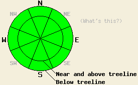
Avalanche Concerns: Wind Slabs
The new snow that falls today will combine with the southwest winds to form small wind slabs on the N-NE-E aspects near and above treeline. These wind slabs should remain very small and shallow since the forecast only calls for one inch of new snow today. Even though these slabs may break in response to a person's weight, dangerous avalanche activity should remain unlikely today due to the small size and shallowness of any new wind slabs. Continue to use caution and evaluate slopes carefully before committing to them. Small and very isolated pockets of where more wind loading has created slightly larger slabs are not impossible. If more snow falls than forecasted, these wind slabs will become larger and more widespread and the avalanche danger will increase.
The avalanche danger should remain LOW for all elevations and aspects today. If more snow falls than forecasted, the avalanche danger will increase. Continue to use normal caution when travelling in the backcountry.
| 0600 temperature: | 17-22 deg. F. |
| Max. temperature in the last 24 hours: | 30-32 deg. F. |
| Average wind direction during the last 24 hours: | East until 5pm yesterday then Southwest |
| Average wind speed during the last 24 hours: | East: 5-10 mph Southwest: 25-30 mph |
| Maximum wind gust in the last 24 hours: | 52 mph |
| New snowfall in the last 24 hours: | trace inches |
| Total snow depth: | 68-98 inches |
For 7000-8000 ft: |
|||
| Tuesday: | Tuesday Night: | Wednesday: | |
| Weather: | Snow showers this morning becoming more widespread during the day. | Snow with snow showers decreasing after midnight. | Mostly cloudy with a slight chance of snow in the morning. |
| Temperatures: | 25-32 deg. F. | 20-29 deg. F. | 34-41 deg. F. |
| Wind direction: | Southwest | Southwest | Southwest |
| Wind speed: | 10-15 mph with gusts to 35 mph | 10-15 mph | around 10 mph |
| Expected snowfall: | up to 1 in. | 1-2 in. | O in. |
For 8000-9000 ft: |
|||
| Tuesday: | Tuesday Night: | Wednesday: | |
| Weather: | Snow showers this morning becoming more widespread during the day. | Snow with snow showers decreasing after midnight. | Mostly cloudy with a slight chance of snow in the morning. |
| Temperatures: | 23-30 deg. F. | 19-25 deg. F. | 34-41 deg. F. |
| Wind direction: | Southwest | Southwest | Southwest |
| Wind speed: | 15-20 mph with gusts to 30 mph increasing to 25-35 mph with gusts to 50 mph | 15-25 mph with gusts to 40 mph | 15-25 mph with gusts to 45 mph |
| Expected snowfall: | 1 in. | 1-2 in. | O in. |


This website is owned and maintained by the non-profit arm of the Sierra Avalanche Center. Some of the content is updated by the USDA avalanche forecasters including the forecasts and some observational data. The USDA is not responsible for any advertising, fund-raising events/information, or sponsorship information, or other content not related to the forecasts and the data pertaining to the forecasts.

