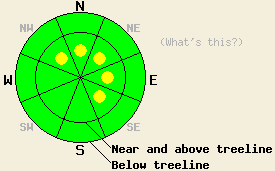
This Avalanche Advisory was published on January 12, 2011:

|
January 12, 2011 at 8:01 am |
|
Pockets of MODERATE avalanche danger exist on NW-N-NE-E-SE aspects near and above treeline on slopes steeper than 35 degrees. Below treeline the avalanche danger should remain LOW for all aspects. |
|
|
|
Forecast Discussion:
2-4 inches of new snow has accumulated across the forecast area above 7000 ft over the last 24 hours. Snow showers should end this morning as the low pressure system moves to the east. A high pressure ridge should start to replace this system and bring warmer temperatures to the area over the next 24 hours. The winds should also decrease today and stay mild through tonight. Another even weaker low should begin to move into the area tomorrow afternoon and evening. As this system approaches tomorrow, the winds should increase again. This system also should bring a chance of snow to the region tomorrow; however, most of the moisture in this system should go north of the forecast area.
Observations from Talking Mountain (photos and more info) and Tamarack Peak (photo, video, and pit profile) yesterday, showed thin, fragile wind slabs forming near ridgelines and poor bonding between the new snow and the old snow surfaces. Skiers triggered some shooting cracks and thin, wind slab failures in both of these areas. These slabs remained small and relatively harmless due to the lack of new snow. In both areas they only existed near ridgelines and did not extend very far down-slope. They only reached 5-6 inches in depth at their deepest. Stability tests on these wind-loaded slopes and on more sheltered areas failed easily at the interface between the old and new snow. In the more sheltered areas only 1 inch of new snow existed.
Primary Avalanche Concern: Wind Slabs
The additional 2-3 inches of snow that fell late yesterday and last night combined with the continued southwest winds has allowed those small, fragile wind slabs that started forming yesterday to grow in size and depth. Wind-loading can multiply the depth of the new snow by several times as evidenced by 5-6 inch deep wind slabs forming with only 1 inch of accumulation yesterday. In heavily wind-loaded areas, these slabs could have easily grown to 1 ft in depth last night. Human triggering of these new slabs will remain possible today. The N-NE-E aspects near and above treeline will hold the largest and most fragile wind slabs. Smaller pockets of these wind slabs may exist on cross-loaded NW and SE aspects. Even though most of these slabs should not entrain enough snow to bury a person, they could push a person into an area that could have serious consequences or into a terrain trap where enough snow could pile up to bury someone. Use clues like blowing snow, cornices, ripples, and other wind created features to determine where wind-loading has occurred. Below treeline the avalanche danger should decrease due to less wind-loading and only a few inches on new snow on the surface. Some shallow sluffing of the new snow may occur on steeper slopes.
The bottom line:
Pockets of MODERATE avalanche danger exist on NW-N-NE-E-SE aspects near and above treeline on slopes steeper than 35 degrees. Below treeline the avalanche danger should remain LOW for all aspects.
Weather Observations from along the Sierra Crest between 8200 ft and 8800 ft:
| 0600 temperature: | 25-29 deg. F. |
| Max. temperature in the last 24 hours: | 27-30 deg. F. |
| Average wind direction during the last 24 hours: | Southwest |
| Average wind speed during the last 24 hours: | 35 mph |
| Maximum wind gust in the last 24 hours: | 74 mph |
| New snowfall in the last 24 hours: | 2-4 inches |
| Total snow depth: | 68-98 inches |
Two-Day Mountain Weather Forecast - Produced in partnership with the Reno NWS
For 7000-8000 ft: |
|||
| Wednesday: | Wednesday Night: | Thursday: | |
| Weather: | Cloudy with a slight chance of snow showers this morning. Then mostly cloudy in the afternoon. | Mostly cloudy | Mostly cloudy with a chance of snow showers in the afternoon |
| Temperatures: | 33-38 deg. F. | 27-32 deg. F. | 37-42 deg. F. |
| Wind direction: | Southwest | Southwest | Southwest |
| Wind speed: | around 10 mph | around 10 mph | 10-15 mph with gusts to 25 mph |
| Expected snowfall: | O in. | O in. | O in. |
For 8000-9000 ft: |
|||
| Wednesday: | Wednesday Night: | Thursday: | |
| Weather: | Cloudy with a slight chance of snow showers this morning. Then mostly cloudy in the afternoon. | Mostly cloudy | Mostly cloudy with a chance of snow showers in the afternoon |
| Temperatures: | 30-35 deg. F. | 28-32 deg. F. | 32-42 deg. F. |
| Wind direction: | Southwest | Southwest | West |
| Wind speed: | 15-25 mph with gusts to 45 mph | 15-25 mph with gusts to 45 mph | 20-35 mph with gusts to 50 mph |
| Expected snowfall: | O in. | O in. | O in. |


