In partnership with: 
|
January 13, 2011 at 7:50 am |
|
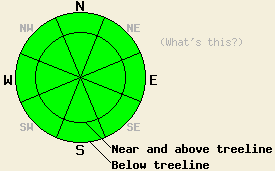
Avalanche danger is LOW for all elevations and aspects. Normal caution is advised. If new snowfall exceeds expected forecast amounts, localized areas of increased avalanche danger may exist. |
|
|
|
A significant storm system will pass by to the north of the forecast area today. Increased cloud cover and isolated to scattered snow and rain showers is all that is expected for locations within the forecast area. New snow accumulation is expected to be less than 0.25 inches. Snow levels are expected to rise to around 7,000' and possibly higher by mid day. Ridgetop winds are moderate in speed out of the southwest this morning. Continued southwest winds with strong gusts are expected this afternoon. Winds are forecast to decrease in speed becoming light to moderate after midnight. Clearing skies overnight are expected to give way to partly to mostly cloudy skies with light winds for tomorrow.
Observations made yesterday on Hidden Peak (West Shore Tahoe area) and on Red Lake Peak (Carson Pass area) indicated a mostly stable snowpack. A thin surface wind crust was noted near and above treeline in both areas. In most locations, this wind crust ranged from 1 to 4 inches thick. Where the wind crust was thicker, it acted as a stable surface slab. On Hidden Peak, a traverse along the summit ridge yielded mostly stable surface wind slab conditions with only one tiny pocket of a very small and very shallow unstable slab that covered a 3' by 3' area and posed no hazard (photo, more info). On Red Lake Peak, a variety of formal and informal tests failed to produce any signs of instability on this surface slab or on near surface faceted crystals a couple of inches deeper in the snowpack (pit profile, photo, more info). The unstable conditions due to recent wind loading that were observed on Tuesday in the Mount Rose and Echo Summit areas (more info) were absent in West Shore and Carson Pass areas yesterday.
Primary Avalanche Concern: Wind Slabs
Widespread stable snowpack conditions are expected today on a regional scale. An isolated spot or two of unstable snowpack conditions on a local scale are not impossible today in areas where the deepest winds slabs formed on Tuesday. In the unlikely event of avalanche activity today, it would be human triggered and occur within the top 1 foot of the snowpack on steep N-NE aspect slope features in near treeline or above treeline terrain. Trace new snow amounts and southwest winds today are not expected to create areas of significant wind loading as snow available for wind transport is minimal. If new snowfall exceeds expected forecast amounts, localized areas of increased avalanche danger may form today.
Avalanche danger is LOW for all elevations and aspects. Normal caution is advised. If new snowfall exceeds expected forecast amounts, localized areas of increased avalanche danger may exist.
| 0600 temperature: | 26 to 36 deg. F. |
| Max. temperature in the last 24 hours: | 32 to 40 deg. F. |
| Average wind direction during the last 24 hours: | Southwest |
| Average wind speed during the last 24 hours: | 30 mph |
| Maximum wind gust in the last 24 hours: | 43 mph |
| New snowfall in the last 24 hours: | O inches |
| Total snow depth: | 67 to 97 inches |
For 7000-8000 ft: |
|||
| Thursday: | Thursday Night: | Friday: | |
| Weather: | Cloudy skies with isolated snow showers in the morning. Scattered snow showers in the afternoon. Snow level may rise above 7,000'. | Cloudy skies with isolated snow showers in the evening. Partly cloudy skies after midnight. | Partly cloudy skies in the morning, becoming mostly cloudy. |
| Temperatures: | 34 to 39 deg. F. | 25 to 35 deg. F. | 38 to 44 deg. F. |
| Wind direction: | SW | W | Variable |
| Wind speed: | 10 to 20 mph with gusts to 30 mph in the afternoon. | 10 to 15 mph with gusts to 40 mph in the evening, becoming light. | Light winds. |
| Expected snowfall: | 0 to trace in. | 0 to trace in. | O in. |
For 8000-9000 ft: |
|||
| Thursday: | Thursday Night: | Friday: | |
| Weather: | Cloudy skies with isolated snow showers in the morning. Scattered snow showers in the afternoon. | Cloudy skies with isolated snow showers in the evening. Partly cloudy skies after midnight. | Partly cloudy skies in the morning, becoming mostly cloudy. |
| Temperatures: | 31 to 38 deg. F. | 24 to 33 deg. F. | 36 to 43 deg. F. |
| Wind direction: | SW | W | NW shifting to NE |
| Wind speed: | 20 to 30 mph with gusts to 50 mph. Gusts to 60 mph in the afternoon. | 15 to 25 mph with gusts to 55 mph. Winds decreasing to 10 to 15 mph with gusts to 30 mph after midnight. | Around 10 mph. |
| Expected snowfall: | 0 to trace in. | 0 to trace in. | O in. |


This website is owned and maintained by the non-profit arm of the Sierra Avalanche Center. Some of the content is updated by the USDA avalanche forecasters including the forecasts and some observational data. The USDA is not responsible for any advertising, fund-raising events/information, or sponsorship information, or other content not related to the forecasts and the data pertaining to the forecasts.

