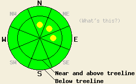
This Avalanche Advisory was published on January 14, 2011:

|
January 14, 2011 at 7:52 am |
|
Above 8,000' in near and above treeline areas, isolated pockets of MODERATE danger may exist on N-NE-E aspects, 37 degrees and steeper. For all other areas, avalanche danger is LOW. |
|
|
|
Forecast Discussion:
Skies have cleared overnight as high pressure builds over the forecast area. The storm system that affected the forecast area yesterday produced significantly more precipitation and wind than the best weather forecast products indicated. Precipitation was some 10 to 30 times greater than forecast amounts and average wind speeds were over double the forecast amount for several hours. Snow level rose through the morning hours up to around 7,800' or so in most areas. Anywhere from 1 to potentially 6 inches of new snow accumulated in areas above 8,000' with the greatest accumulations along the Sierra Crest in the northern 1/3 of the forecast area. Ridgetop winds shifted to the east overnight and are light to moderate in speed this morning. Light to moderate northeast to east winds are forecast for today. An air temperature inversion is in place this morning holding above freezing air temperatures in many but not all locations above 7,000'. This will give many areas a significant head start on daytime warming with maximum daytime air temperatures in the upper 30s to mid 40s expected for most areas.
Despite much greater than forecast precipitation and winds yesterday, observed evidence of snowpack instability was minimal. Observations made on Trimmer Peak (Luther Pass area) revealed wind loading 4 to 6 inches deep in lee areas. Ski cuts on wind loaded test slopes failed to produce any cracking or other evidence of slab instability (video, more info). Skier trigger roller balls due to the wet surface snow were widespread. In the Deep Creek drainage, similar widespread skier triggered roller ball activity was observed on N aspects below treeline at around 8,000' (photos, more info). Observations made on Tamarack Peak (Mount Rose area) prior to mid morning revealed similar blowing snow conditions, but with no deposition at that time (pit profile, more info). Remote sensors report that a period of higher intensity precipitation occurred during the afternoon hours, after most of these observations were made.
Avalanche Concern #1: Storm snow
In areas above 8,000', some isolated pockets of unstable storm snow slab are possible. This is only expected in the areas that were most heavily wind loaded yesterday, mainly N-NE-E aspects near and above treeline. Ridgetop winds that shifted to the east overnight will lightly scour these avalanche start zones today, but some lingering instability of storm snow slabs may occur. Obvious signs of instability are not expected to readily occur today, so careful slope evaluation will be necessary to discover areas of instability ahead of time. Wind transport by east winds today is not expected to move sufficient snow onto S-SW-W aspects to create a snowpack instability concern.
Avalanche Concern #2: Wet snow
The roller ball type wet snow surface instability that was observed yesterday may continue today in areas where the snow surface did not refreeze overnight. Clearing skies opened the door of radiational cooling to create snow surface refreeze last night in most areas despite above freezing air temperatures in many locations. With snow surface refreeze expected to have occurred in most areas, any areas of wet snow instability will be limited today.
The bottom line:
Above 8,000' in near and above treeline areas, isolated pockets of MODERATE danger may exist on N-NE-E aspects, 37 degrees and steeper. For all other areas, avalanche danger is LOW.
Weather Observations from along the Sierra Crest between 8200 ft and 8800 ft:
| 0600 temperature: | 24 to 36 deg. F. |
| Max. temperature in the last 24 hours: | 35 to 38 deg. F. |
| Average wind direction during the last 24 hours: | Southwest shifting to east |
| Average wind speed during the last 24 hours: | Prior to 6pm 50 mph, after 6pm 17 mph |
| Maximum wind gust in the last 24 hours: | 81 mph |
| New snowfall in the last 24 hours: | 1 to 6 inches |
| Total snow depth: | 67 to 97 inches |
Two-Day Mountain Weather Forecast - Produced in partnership with the Reno NWS
For 7000-8000 ft: |
|||
| Friday: | Friday Night: | Saturday: | |
| Weather: | Partly cloudy skies in the morning, becoming mostly cloudy. | Partly cloudy skies. | Partly cloudy skies in the morning, becoming mostly cloudy. |
| Temperatures: | 42 to 47 deg. F. | 25 to 32 deg. F. | 42 to 47 deg. F. |
| Wind direction: | NE | NE | NE shifting to W in the afternoon. |
| Wind speed: | Up to 10 mph. | Up to 10 mph in the evening becoming light. | Around 10 mph. |
| Expected snowfall: | O in. | O in. | O in. |
For 8000-9000 ft: |
|||
| Friday: | Friday Night: | Saturday: | |
| Weather: | Partly cloudy skies in the morning, becoming mostly cloudy. | Partly cloudy skies. | Partly cloudy skies in the morning, becoming mostly cloudy. |
| Temperatures: | 39 to 45 deg. F. | 30 to 35 deg. F. | 39 to 45 deg. F. |
| Wind direction: | NE | N | W |
| Wind speed: | 15 to 20 mph with gusts to 30 mph. | Around 10 mph. | 10 to 15 mph with gusts to 25 mph. Gusts increasing to 35 mph in the afternoon. |
| Expected snowfall: | O in. | O in. | O in. |


