In partnership with: 
|
January 16, 2011 at 8:00 am |
|
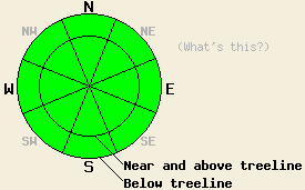
Avalanche danger should remain LOW for all elevations and aspects today. Normal caution is advised. |
|
|
|
The high pressure ridge lingering over the region will keep temperatures above normal with daytime highs climbing back into the mid to upper 40's and maybe even the low 50's above 7000 ft today. Cloud cover and westerly wind should increase today due to a storm system north of the forecast area. As this system moves east tomorrow, the winds should start to calm back down and the cloud cover should start to decrease.
In the Mt. Rose area the rain crust extended up to 9400 ft on Mt Houghton. This 2 inch thick, firm, and supportable crust existed on all aspects up to that elevation. Above 9400 ft. a firm, 3-4 inch thick wind crust existed on the N-NE-E aspects. Hand pits indicated that this thin wind crust sat on top of a layer of softer snow and that it had not fully bonded to the snow below it (video). Observations from the Bear Valley area and from the Mt Rose area yesterday showed that melt-freeze conditions combined with the rain have formed an even thicker crust on the more southerly aspects. These southerly aspects did soften enough in in the Mt Rose area for a few small skier-triggered roller balls to occur (photo).
Avalanche Concerns:
Dangerous avalanche activity will remain unlikely today. Recent observations continue to show a well consolidated snowpack in most areas. Some small roller balls or wet, loose snow sluffs may occur on southerly, sun-exposed aspects; however, these should remain small due to the weak winter sun and more widespread cloud cover. Other very isolated pockets of weakness could still linger at the highest elevations (above 9500 ft) on wind-loaded slopes. These should also remain very small, very shallow, and difficult to trigger. Continue to travel with caution in the backcountry and evaluate slopes carefully before committing to them.
Avalanche danger should remain LOW for all elevations and aspects today. Normal caution is advised.
| 0600 temperature: | 39 deg. F. |
| Max. temperature in the last 24 hours: | 46 deg. F. |
| Average wind direction during the last 24 hours: | West to Northwest |
| Average wind speed during the last 24 hours: | 10-20 mph |
| Maximum wind gust in the last 24 hours: | 39 mph |
| New snowfall in the last 24 hours: | O inches |
| Total snow depth: | 65-94 inches |
For 7000-8000 ft: |
|||
| Sunday: | Sunday Night: | Monday: | |
| Weather: | Mostly cloudy | Partly cloudy | Partly cloudy |
| Temperatures: | 46-53 deg. F. | 33-38 deg. F. | 45-52 deg. F. |
| Wind direction: | West | West | West |
| Wind speed: | 10-15 mph with gusts to 30 mph | 10 mph with gusts to 25 mph | 10 mph with gusts to 25 mph |
| Expected snowfall: | O in. | O in. | O in. |
For 8000-9000 ft: |
|||
| Sunday: | Sunday Night: | Monday: | |
| Weather: | Mostly cloudy | Partly cloudy | Partly cloudy |
| Temperatures: | 39-46 deg. F. | 31-37 deg. F. | 39-45 deg. F. |
| Wind direction: | West | Northwest | Northwest |
| Wind speed: | 20-25 mph with gusts to 65 mph | 20-35 mph with gusts to 70 mph | 20-30 mph with gusts to 70 mph decreasing to 50 mph in the afternoon |
| Expected snowfall: | O in. | O in. | O in. |


This website is owned and maintained by the non-profit arm of the Sierra Avalanche Center. Some of the content is updated by the USDA avalanche forecasters including the forecasts and some observational data. The USDA is not responsible for any advertising, fund-raising events/information, or sponsorship information, or other content not related to the forecasts and the data pertaining to the forecasts.

