In partnership with: 
|
January 17, 2011 at 8:00 am |
|
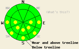
This morning the avalanche danger is LOW for all elevations and aspects. Pockets of MODERATE avalanche danger should form on the E-SE-S-SW-W aspects 35 degrees and steeper due to daytime warming. |
|
|
|
The high pressure parked near the forecast area should bring another day of close to record high temperatures (more info). The forecast calls for daytime highs in the upper 40's and low 50's above 7000 ft again today. The cloud cover started to decrease last evening and skies should remain mostly clear to partly cloudy for the next few days. The northerly winds should also continue for the next 24 hours.
Due to cloudy skies and above freezing temperatures the snow surface did not refreeze on Saturday night. It continued to soften and melt yesterday. Wet, sticky surface snow existed on all aspects and at all elevations in the Donner Summit area and in the Mt. Rose area (pit profile 1, pit profile 2) yesterday. On the northerly aspects, about 4 inches of this wet snow existed on the surface in these areas. The southerly aspects had much deeper wet snow especially below 8200 ft. In the Donner Summit area, the wet snow on the southerly aspects become unsupportable "mush" by midday. Observers reported skier-triggerred collapsing in areas near rocks or bushes on these southerly slopes (more details). Natural and skier-triggerred roller balls also occurred on the southerly aspects in the Donner Summit and Mt. Rose areas. None of these entrained enough snow to bury a person. On Ralston Peak on a sun-exposed, southeast aspect, larger roller balls occurred as well as a small, skier-triggered, wet slide (more details). Again neither of these entrained enough snow to bury a person.
Primary Avalanche Concern: Wet Snow Instabilities
Even though less cloud cover last night should have allowed the snow surface to refreeze some, temperatures well above freezing that have persisted for more three days should have prevented a deeper, stronger refreeze. As the day warms up and the sun comes out, this weak refreeze should melt quickly and introduce more free water into the snowpack. This water will weaken the snowpack and allow more wet snow activity to become possible today. Roller balls or wet, loose snow sluffs that are not large enough to bury a person should comprise most of this wet snow activity. However, some wet slides may occur on the most sun-exposed aspects on the southern half of the compass that are large enough to bury a person or that could push someone into an area that could have consequences. Use clues like shin-deep wet snow, roller balls, and wet snow sluffs to determine where wet snow instabilities may lurk.
This morning the avalanche danger is LOW for all elevations and aspects. Pockets of MODERATE avalanche danger should form on the E-SE-S-SW-W aspects 35 degrees and steeper due to daytime warming.
| 0600 temperature: | 39-43 deg. F. |
| Max. temperature in the last 24 hours: | 46-54 deg. F. |
| Average wind direction during the last 24 hours: | Northwest |
| Average wind speed during the last 24 hours: | 15-20 mph |
| Maximum wind gust in the last 24 hours: | 46 mph |
| New snowfall in the last 24 hours: | O inches |
| Total snow depth: | 63-92 inches |
For 7000-8000 ft: |
|||
| Monday: | Monday Night: | Tuesday: | |
| Weather: | Partly cloudy | Partly cloudy | Partly cloudy |
| Temperatures: | 48-53 deg. F. | 29-35 deg. F. | 44-49 deg. F. |
| Wind direction: | Northwest | East to Northeast | North |
| Wind speed: | 10-15 mph with gusts to 25 mph | 10 mph | 10 mph |
| Expected snowfall: | O in. | O in. | O in. |
For 8000-9000 ft: |
|||
| Monday: | Monday Night: | Tuesday: | |
| Weather: | Partly cloudy | Partly cloudy | Partly cloudy |
| Temperatures: | 41-47 deg. F. | 33-38 deg. F. | 35-41 deg. F. |
| Wind direction: | Northwest | Northwest shifting to the northeast | Northeast shifting to the northwest |
| Wind speed: | 20-30 mph with gusts to 50 mph | 15-20 mph with gusts to 30 mph becoming 10-20 mph with gusts to 45 mph after midnight | 10-15 mph increasing to 15-20 mph with gusts to 45 mph in the afternoon |
| Expected snowfall: | O in. | O in. | O in. |


This website is owned and maintained by the non-profit arm of the Sierra Avalanche Center. Some of the content is updated by the USDA avalanche forecasters including the forecasts and some observational data. The USDA is not responsible for any advertising, fund-raising events/information, or sponsorship information, or other content not related to the forecasts and the data pertaining to the forecasts.

