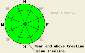
This Avalanche Advisory was published on January 21, 2011:

|
January 21, 2011 at 7:44 am |
|
Avalanche danger is LOW for all elevations and aspects. Normal caution is advised. |
|
|
|
Forecast Discussion:
An air temperature inversion is once again in place over the forecast area this morning. The vast majority of remote sensors in the mid and upper elevations report that overnight air temperatures remained above freezing. An additional 3 to 5 degrees of daytime warming is expected today over what was observed yesterday. Ridgetop winds remain out of the northeast this morning and are light to moderate in speed. Winds are forecast to shift to the north today and remain light to moderate in speed over the ridgetops.
Observations made yesterday on Relay Ridge (Mount Rose area) and on Donner Pass (Donner Summit area) both revealed the expected snow surface melting on southerly aspects and frozen surface conditions on northerly aspects. On Donner Pass the snow surface mid day on north aspects at 7,188' was a very hard and supportable 3 inch thick melt freeze crust with no boot penetration (pit profile, more info). Southerly aspects in this area received minimal snow surface melting with light NE winds keeping air temperatures cooler at this location. On Relay Ridge, N-NE-E aspects and shaded areas above 9,100' held a 5 inch thick layer of cold and consolidated snow below a very thin melt freeze crust at the snow surface (pit profile, more info). On SE-S-SW aspects widespread melt-freeze conditions were occurring up to the highest elevation traveled of 10,150'. The snow surface remained supportable in all areas traveled between 10,150' and 8,650' at 1pm. Ski penetration at that time did not exceeded 2 inches.
Avalanche Concerns:
Snow surface refreeze last night at the mid and upper elevations was fully dependent on radiational cooling under clear skies. This is different than the stronger refreeze that occurred Tuesday and Wednesday nights from below freezing air temperatures. Snow surface melting yesterday on southerly aspects did not fully melt through the thicker surface melt freeze layer that existed yesterday morning. As a result, last nights snow surface refreeze is effectively thicker and will remain more supportable during snow surface melting today. Continued NE to N winds will again create some convective cooling, slowing snow surface melting on N-NE-E aspects. Most northerly aspects are likely to remain frozen all day again today. During the mid day and afternoon hours on southerly aspects, very shallow and slow moving wet snow sluffs involving the top couple of inches of wet surface snow may become possible. This is expected to remain isolated to steep open areas with direct sun exposure on SE-S-SW aspects. The anticipated size of any wet snow sluffs that occur today are not expected to provide a significant hazard to backcountry travelers.
Weather Observations from along the Sierra Crest between 8200 ft and 8800 ft:
| 0600 temperature: | 31 to 37 deg. F. |
| Max. temperature in the last 24 hours: | 44 to 52 deg. F. |
| Average wind direction during the last 24 hours: | Northeast |
| Average wind speed during the last 24 hours: | 23 mph |
| Maximum wind gust in the last 24 hours: | 36 mph |
| New snowfall in the last 24 hours: | O inches |
| Total snow depth: | 61 to 90 inches |
Two-Day Mountain Weather Forecast - Produced in partnership with the Reno NWS
For 7000-8000 ft: |
|||
| Friday: | Friday Night: | Saturday: | |
| Weather: | Sunny skies. | Partly cloudy skies. | Sunny skies. |
| Temperatures: | 43 to 49 deg. F. | 28 to 35 deg. F. | 40 to 46 deg. F. |
| Wind direction: | NE shifting to N | Variable | NE |
| Wind speed: | Light winds | Light winds | 10 to 15 mph with gusts to 25 mph. |
| Expected snowfall: | O in. | O in. | O in. |
For 8000-9000 ft: |
|||
| Friday: | Friday Night: | Saturday: | |
| Weather: | Sunny skies. | Partly cloudy skies. | Sunny skies. |
| Temperatures: | 36 to 43 deg. F. | 26 to 32 deg. F. | 32 to 39 deg. F. |
| Wind direction: | NE shifting to N | N | NE |
| Wind speed: | 10 to 20 mph with gusts to 35 mph. | 15 to 20 mph with gusts to 35 mph. | 20 to 35 mph with gusts to 60 mph. |
| Expected snowfall: | O in. | O in. | O in. |


