In partnership with: 
|
January 24, 2011 at 8:00 am |
|
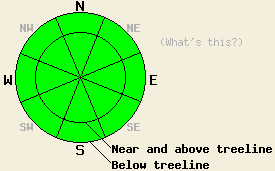
The avalanche danger should remain LOW for all elevations and aspects today. Continue to use normal caution when traveling in the backcountry |
|
|
|
Some clouds should develop over the forecast area as a small low pressure trough passes near the region. These clouds should dissipate tonight. The forecast calls for a clear and sunny day tomorrow. The northeast winds should increase today and tonight due to that small low pressure. Even though today's cloud cover should keep the temperatures a little cooler, they could still climb into the mid 40's above 7000 ft.
Yesterday, temperatures did not climb as high as they could have, nor did the snow surface soften very much due to an unexpected layer of clouds over the region. This layer of clouds did not clear off until 1pm in most areas. By then the sun did not have enough time to melt much of the snow surface even on the southerly aspects. In Negro Canyon the snow surface remained hard and frozen on all aspects up to 7800 ft until at least noon. Test pits in this area on southerly and northerly aspects showed stable results with a thick layer of melt-freeze snow capping the snowpack.
Avalanche Concerns:
As the spring-like weather continues, the balance between the time the snowpack spends melting and the time it spends freezing will determine both the avalanche concerns and whether or not fun recreation conditions exist. Over the last 48 hours only a few hours of melting have occurred each day, and the snowpack has spent most of its time freezing tipping the scales towards the frozen side of the balance. These conditions make the snowpack very stable; however, it seems like ice skates may be a better recreation tool than skis, boards, or snowmobiles for all but a few hours of the day. Today the strong refreeze, increased cloud cover, northeasterly winds, and low sun angles will work to keep the balance tipped in favor of the frozen side. On the melting side, slightly warmer temperatures and sunny skies this morning should allow enough melting to occur for the snow surface to soften into good corn snow for a few hours on sun-exposed southerly aspects. However, what melting does occur today should not be enough for wet snow instabilities to form. Most northerly aspects should remain frozen today.
The avalanche danger should remain LOW for all elevations and aspects today. Continue to use normal caution when traveling in the backcountry
| 0600 temperature: | 30-32 deg. F. |
| Max. temperature in the last 24 hours: | 41-48 deg. F. |
| Average wind direction during the last 24 hours: | West during the day yesterday then shifting to the Northeast |
| Average wind speed during the last 24 hours: | 10 mph |
| Maximum wind gust in the last 24 hours: | 26 mph |
| New snowfall in the last 24 hours: | O inches |
| Total snow depth: | 60-89 inches |
For 7000-8000 ft: |
|||
| Monday: | Monday Night: | Tuesday: | |
| Weather: | Partly cloudy becoming mostly cloudy this afternoon | Partly cloudy with most clouds dissipating overnight | Sunny |
| Temperatures: | 44-49 deg. F. | 27-34 deg. F. | 42-47 deg. F. |
| Wind direction: | Northeast | East | East |
| Wind speed: | 5-15 mph | 5-15 mph with gusts to 25 mph | 10-15 mph with gusts to 25 mph |
| Expected snowfall: | O in. | O in. | O in. |
For 8000-9000 ft: |
|||
| Monday: | Monday Night: | Tuesday: | |
| Weather: | Partly cloudy becoming mostly cloudy this afternoon | Partly cloudy with most clouds dissipating overnight | Sunny |
| Temperatures: | 39-44 deg. F. | 26-31 deg. F. | 37-42 deg. F. |
| Wind direction: | Northeast | East | Northeast |
| Wind speed: | 10-20 mph with gusts to 35 mph decreasing to 10-15 mph with gusts to 25 mph in the afternoon | 10-15 mph with gusts to 30 mph increasing to 20-30 mph with gusts to 50 mph after midnight | 20-30 mph with gusts to 45 mph |
| Expected snowfall: | O in. | O in. | O in. |


This website is owned and maintained by the non-profit arm of the Sierra Avalanche Center. Some of the content is updated by the USDA avalanche forecasters including the forecasts and some observational data. The USDA is not responsible for any advertising, fund-raising events/information, or sponsorship information, or other content not related to the forecasts and the data pertaining to the forecasts.

