In partnership with: 
|
January 25, 2011 at 7:57 am |
|
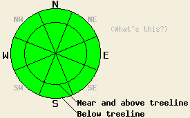
Avalanche danger remains LOW for all elevations and aspects. Normal caution is advised. |
|
|
|
A weather system passing far to the east of the forecast area today will cause increased ridgetop winds through tomorrow morning. As the day progresses, increasing winds are expected to become moderate in speed and shift from northeast to north. Occasional strong gusts are expected over the ridgetops. An air temperature inversion is in place this morning. Air temperatures remained above freezing overnight in the vast majority of mid and upper elevation locations. Daytime highs are expected to warm into the upper 30s to upper 40s today for areas between 7,000' and 10,000'. Minimal if any cloud cover is expected over the next 24 hours.
Observations made yesterday on Rose Knob Peak (Mt. Rose area) noted a slow but steady snow surface melting occurring at the upper elevations. More freezing than melting had occurred in this area over this past weekend. At noon near the summit on a S aspect at 9,400', snow surface melting had occurred in the top 2 inches on the snowpack. Below the melt layer, 14 inches of hard ice from melt freeze over the past 2 weeks existed. At 1:30 pm on a S aspect at 7,600', surface wet snow was up to 6 inches deep with a 2 inch layer of hard ice below. Below the ice layer was approximately 3.3 feet of wet snow down to ground level per ski pole probing. Ski and boot penetration in this entire area never exceeded 4 inches. The snowpack remained very supportable on SE-S aspects from 9,700' down to 7,400' right up until departure from the area at 1:45 pm.
Avalanche Concerns:
Clear skies last night are expected to have allowed for significant radiational cooling of the upper portion of the snowpack. A decent overnight snow surface refreeze is expected to have occurred despite above freezing air temperatures last night in the vast majority of mid and upper elevation areas. At the lower elevations, below freezing air temperatures will have created to solid refreeze of the snowpack. Northerly aspects are expected to remain frozen all day. On southerly aspects, wet snow instabilities are unlikely to form today. That said, pay attention to the mid elevations where the warmest air temperatures occurred last night and air temperatures in the 40s are expected today. In the unlikely event that the melt freeze layer fully melts and becomes unsupportable during the mid to late afternoon hours on mid elevation SE-S-SW aspects, isolated human triggered wet snow avalanches would not be impossible.
Avalanche danger remains LOW for all elevations and aspects. Normal caution is advised.
| 0600 temperature: | 28 to 37 deg. F. |
| Max. temperature in the last 24 hours: | 37 to 45 deg. F. |
| Average wind direction during the last 24 hours: | Northeast |
| Average wind speed during the last 24 hours: | 18 mph |
| Maximum wind gust in the last 24 hours: | 28 mph |
| New snowfall in the last 24 hours: | O inches |
| Total snow depth: | 60 to 88 inches |
For 7000-8000 ft: |
|||
| Tuesday: | Tuesday Night: | Wednesday: | |
| Weather: | Sunny skies. | Clear skies. | Sunny skies. |
| Temperatures: | 43 to 48 deg. F. | 27 to 35 deg. F. | 43 to 48 deg. F. |
| Wind direction: | N | E | E |
| Wind speed: | 5 to 15 mph. | 10 to 15 mph. | 5 to 15 mph. |
| Expected snowfall: | O in. | O in. | O in. |
For 8000-9000 ft: |
|||
| Tuesday: | Tuesday Night: | Wednesday: | |
| Weather: | Sunny skies. | Clear skies. | Sunny skies. |
| Temperatures: | 38 to 43 deg. F. | 30 to 35 deg. F. | 38 to 43 deg. F. |
| Wind direction: | N | NE | NE shifting to E |
| Wind speed: | 10 to 20 mph with gusts to 35 mph. Ridgetop gusts up to 50 mph. | 15 to 25 mph with gusts to 40 mph. Ridgetop gusts to 60 mph. | 15 to 25 mph with gusts to 40 mph. Ridgetop gusts to 60 mph. Winds decreasing to 10 to 20 mph with gusts to 30 mph in the afternoon. |
| Expected snowfall: | O in. | O in. | O in. |


This website is owned and maintained by the non-profit arm of the Sierra Avalanche Center. Some of the content is updated by the USDA avalanche forecasters including the forecasts and some observational data. The USDA is not responsible for any advertising, fund-raising events/information, or sponsorship information, or other content not related to the forecasts and the data pertaining to the forecasts.

