In partnership with: 
|
January 26, 2011 at 7:40 am |
|
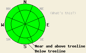
Avalanche danger remains LOW for all elevations and aspects. Normal caution is advised. |
|
|
|
Another weather system will pass by to the east of the forecast area today. Yesterday's forecast moderate to strong wind event never really materialized. Ridgetop winds remained light out of the east through the day before increasing to moderate in speed during the evening and overnight hours. Winds remain moderate in speed out of the east this morning and are forecast to decrease in speed as the day progresses. Today's northeast winds lasting through the morning hours are expected to bring a little bit of cooler air into the region, keeping maximum daytime air temperatures a couple of degrees cooler today than yesterday. This same colder flow aloft last night brought air temperatures down below freezing overnight for all locations within the forecast area.
Observations made yesterday on Silver Peak (Pole Creek area) and on Dick's Peak (Desolation Wilderness area) both revealed similar conditions. Melt freeze cycles are continuing to occur on southerly aspects while northerly aspects remain frozen. Both areas held evidence of a solid overnight refreeze of surface snow that had melted the day before. Wet snow that formed on SE-S-SW aspects in response to daytime warming remained supportable throughout the day with no evidence of wet snow instability. Northerly aspects hold stable but highly variable snow surface conditions. These surfaces range from shear ice to breakable crust to firm wind scoured surfaces to isolated areas of soft snow where the surface crust has broken down through the faceting process. For Silver Peak pit profile, photo, and more info click here. For Dick's Peak photo and more info click here.
Avalanche Concerns:
Avalanche concerns for today are few. All of the right ingredients of below freezing air temperatures and clear skies were in place last night for a solid snow surface refreeze to occur. Melting of surface snow in areas of direct sun exposure will occur again today, but areas of wet snow instability are unlikely to form. January levels of incoming solar radiation, maximum daytime air temperatures in the upper 30s to upper 40s, and well established drainage in the snowpack are expected to keep excessive free water from forming. This will keep the likelihood of wet snow avalanches in the isolated and unlikely category. On the northerly aspects expect to find variable forms of frozen ice and snow all day long.
Avalanche danger remains LOW for all elevations and aspects. Normal caution is advised.
| 0600 temperature: | 24 to 34 deg. F. |
| Max. temperature in the last 24 hours: | 38 to 49 deg. F. |
| Average wind direction during the last 24 hours: | East |
| Average wind speed during the last 24 hours: | 27 mph |
| Maximum wind gust in the last 24 hours: | 43 mph |
| New snowfall in the last 24 hours: | O inches |
| Total snow depth: | 59 to 88 inches |
For 7000-8000 ft: |
|||
| Wednesday: | Wednesday Night: | Thursday: | |
| Weather: | Sunny skies. | Clear skies. | Sunny skies. |
| Temperatures: | 43 to 48 deg. F. | 28 to 35 deg. F. | 48 to 53 deg. F. |
| Wind direction: | NE to E | E | Variable |
| Wind speed: | 5 to 15 mph with gusts to 25 mph. | 5 to 10 mph becoming light. | Light winds. |
| Expected snowfall: | O in. | O in. | O in. |
For 8000-9000 ft: |
|||
| Wednesday: | Wednesday Night: | Thursday: | |
| Weather: | Sunny skies. | Clear skies. | Sunny skies. |
| Temperatures: | 38 to 45 deg. F. | 30 to 37 deg. F. | 43 to 50 deg. F. |
| Wind direction: | NE to E | E | NE |
| Wind speed: | 20 to 30 mph with gusts to 40 mph. Winds decreasing to 10 to 20 mph in the afternoon. | 10 to 15 mph. | Around 10 mph becoming light. |
| Expected snowfall: | O in. | O in. | O in. |


This website is owned and maintained by the non-profit arm of the Sierra Avalanche Center. Some of the content is updated by the USDA avalanche forecasters including the forecasts and some observational data. The USDA is not responsible for any advertising, fund-raising events/information, or sponsorship information, or other content not related to the forecasts and the data pertaining to the forecasts.

