In partnership with: 
|
January 27, 2011 at 7:56 am |
|
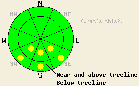
Early this morning, avalanche danger is LOW for all elevations and aspects. Pockets of MODERATE danger may form today on SE-S-SW aspects 35 degrees and steeper in response to daytime warming. |
|
|
|
High pressure remains in place over the forecast area at this time. Thin high cloud cover moved into most of the forecast area late yesterday afternoon and has continued overnight into this morning. Ridgetop winds have decreased to light in speed over the past 24 hours. Winds shifted from east to west around 2am this morning. In response to the westerly flow, many ridgetop remote sensors in the 8,300' to 8,700' range are reporting significant warming since around 2am this morning with air temperatures up into the 40s. Air temperatures warmed around 3 to 7 degrees between 1am and 5am in many ridgetop areas. Along the mountain valley floors, air temperature inversion is holding cold air with below freezing temperatures in most locations.
Observations made yesterday on Mt. Tallac (Desolation Wilderness area) continued to indicate that in general the vast majority of snow surface melting is occurring on SE-S-SW aspects. In this area some snow surface melt was noted on E aspects, but not nearly as much as on the SE-S aspects traveled up to 9,000'. By 1pm E aspects between 9,000' down to 6,500' had refrozen with supportable crust, even in open areas with continued low angle sun exposure. Evidence of a good snow surface refreeze from Tuesday night was seen in hand pits. At 12:30pm at 8,560' on an open SE aspect 36 degree slope near treeline, 2 to 3 inches of wet surface snow sat on top of 14 inches of hard ice (photo, more info). Wet grains with minimal free water existed below the ice layer. No evidence of wet snow instability was observed to occur in this area during the day yesterday. Northerly aspects were noted to remain frozen all day.
Avalanche concerns:
Greater concern for human triggered wet loose snow avalanches exists today than over the past several days. A fair amount of snow surface refreeze is expected to have occurred last night, but not as much as in the past several nights. Last night's cloud cover and warming air temperatures during the early morning hours are expected to have reduced the amount of snow surface refreeze that occurred via radiational cooling. Air temperatures are forecast to warm well into the 40s and possibly the lower 50s today. With the aid of light west winds, more snow surface melting is possible today than over the past several days which saw colder light to moderate speed east winds. In most areas it is unlikely that the thick melt freeze ice layer that has been observed on southerly aspects around the forecast area over the past several days will fully melt. The concern is that increased snow surface melting today will allow enough wet snow to form on top of this ice layer that human triggered wet loose snow avalanches may become possible in steep areas on SE-S-SW aspects.
Early this morning, avalanche danger is LOW for all elevations and aspects. Pockets of MODERATE danger may form today on SE-S-SW aspects 35 degrees and steeper in response to daytime warming.
| 0600 temperature: | 37 to 43 deg. F. |
| Max. temperature in the last 24 hours: | 41 to 46 deg. F. |
| Average wind direction during the last 24 hours: | East shifting to west |
| Average wind speed during the last 24 hours: | 18 mph |
| Maximum wind gust in the last 24 hours: | 42 mph |
| New snowfall in the last 24 hours: | O inches |
| Total snow depth: | 59 to 88 inches |
For 7000-8000 ft: |
|||
| Thursday: | Thursday Night: | Friday: | |
| Weather: | Sunny skies. | Clear skies. | Sunny skies. |
| Temperatures: | 47 to 52 deg. F. | 27 to 34 deg. F. | 47 to 52 deg. F. |
| Wind direction: | NW | Variable | Variable |
| Wind speed: | Light winds. | Light winds. | Light winds. |
| Expected snowfall: | O in. | O in. | O in. |
For 8000-9000 ft: |
|||
| Thursday: | Thursday Night: | Friday: | |
| Weather: | Sunny skies. | Clear skies. | Sunny skies. |
| Temperatures: | 41 to 48 deg. F. | 29 to 35 deg. F. | 41 to 48 deg. F. |
| Wind direction: | NW | Variable | Variable becoming NW in the afternoon. |
| Wind speed: | Around 10 mph. | Light winds. | Up to 10 mph. |
| Expected snowfall: | O in. | O in. | O in. |


This website is owned and maintained by the non-profit arm of the Sierra Avalanche Center. Some of the content is updated by the USDA avalanche forecasters including the forecasts and some observational data. The USDA is not responsible for any advertising, fund-raising events/information, or sponsorship information, or other content not related to the forecasts and the data pertaining to the forecasts.

