In partnership with: 
|
January 31, 2011 at 8:00 am |
|
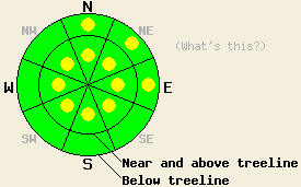
Near and above treeline, pockets of MODERATE avalanche danger exist on all aspects on slopes 35 degrees and steeper. Below treeline, avalanche danger is LOW with pockets of MODERATE danger on N-NE-E aspects 37 degrees and steeper. Human triggered avalanches remain possible today in a variety of areas. Use good travel habits to minimize risk. |
|
|
|
The storm system that passed through the forecast area yesterday left behind new snow amounts ranging from 5 to 12 inches. The greatest accumulations were observed along the Sierra Crest. Most of the snowfall occurred between 2am and 10am in the northern portion of the forecast area and between 7am and 1pm in the southern portion of the forecast area. While overall snowfall totals were similar for locations along the Sierra Crest, New snow amounts that accumulated during the past 24 hours were much higher in the south with 4 to 7 inches compared to 1 to 2 inches during the past 24 hours in the north due to this difference in timing. During the afternoon hours partial clearing with occasional sun breaks were noted in most areas. Ridgetop winds shifted from southwest to east mid day yesterday and became moderate in speed around 5pm. Moderate speed east winds continued overnight and are expected to continue through Tuesday.
Two small natural soft slab avalanches were noted yesterday on Mt. Lola (Independence Lake area). These two avalanches appeared to have occurred at different times during the early morning hours, but adjacent to each other in the summit bowl at 9,080' on a NE aspect 37 degree slope in near treeline terrain. Several test pits and numerous snowmobile cuts on nearby test slopes were able to identify the 6 to 10 inch thick wind slab that had failed in the two avalanches, but were unable to reveal any additional signs of ongoing instability (photo, video, more info). Wind loading up to 2.5 feet deep with a higher density wind slab on top was observed very close to the summit ridge. Dramatic decreases in wind loading deposition and slab hardness existed 100' below the ridge. On the east ridge of Tamarack Peak (Mt. Rose area) significantly less new snow was observed with very little evidence of wind loading. Small skier triggered sluffs were noted in steeper terrain. No real evidence of slab formation existed in this area yesterday (photos, pit profile, more info). On Donner Ridge (Donner Summit area) increasing east winds were observed to begin consistently transporting snow at 5pm.
Primary Avalanche Concern: Wind Slabs
Moderate speed east winds that were observed moving snow yesterday evening are expected to have created redistribution of storm snow and wind loading overnight in lee areas. Some amount of storm snow will have been scoured from N-NE-E aspects and deposited onto S-SW-W-NW aspects. Pockets of fresh slabs less than 1 foot deep are expected today in near and above treeline terrain. Lingering instability of wind slabs that formed yesterday on N-NE-E aspects remains possible as well.
Secondary Avalanche Concern: Storm Snow
Overnight, around 1 to 3 inches of storm snow settlement was reported by remote sensors. Settlement will have increased the strength of the storm snow and should reduce the amount of loose snow sluffs today verses yesterday. This will also enhance the slab characteristics of the recent storm snow. If bonds within the storm snow are forming faster than bonding to the variety of high density crusts and lower density near surface faceted crystals that exist at the old snow surface, areas of ongoing instability may occur. Steep N-NE-E aspects both above and below treeline hold potential for this concern. Slope by slope evaluation is a wise strategy today given the high degree of variability at the old snow surface on northerly aspects.
Near and above treeline, pockets of MODERATE avalanche danger exist on all aspects on slopes 35 degrees and steeper. Below treeline, avalanche danger is LOW with pockets of MODERATE danger on N-NE-E aspects 37 degrees and steeper. Human triggered avalanches remain possible today in a variety of areas. Use good travel habits to minimize risk.
| 0600 temperature: | 18 to 21 deg. F. |
| Max. temperature in the last 24 hours: | 27 to 30 deg. F. |
| Average wind direction during the last 24 hours: | southwest shifting to east |
| Average wind speed during the last 24 hours: | 29 mph |
| Maximum wind gust in the last 24 hours: | 44 mph |
| New snowfall in the last 24 hours: | 1 to 7 inches |
| Total snow depth: | 63 to 90 inches |
For 7000-8000 ft: |
|||
| Monday: | Monday Night: | Tuesday: | |
| Weather: | Partly cloudy skies. | Partly cloudy skies in the evening, becoming clear. | Sunny skies. |
| Temperatures: | 29 to 36 deg. F. | 7 to 14 deg. F. | 21 to 28 deg. F. |
| Wind direction: | N to E | NE | NE |
| Wind speed: | 15 to 25 mph with gusts to 40 mph. | 10 to 15 mph with gusts to 30 mph. | 10 to 20 mph with gusts to 35 mph. |
| Expected snowfall: | O in. | O in. | O in. |
For 8000-9000 ft: |
|||
| Monday: | Monday Night: | Tuesday: | |
| Weather: | Partly cloudy skies. | Partly cloudy skies in the evening, becoming clear. | Sunny skies. |
| Temperatures: | 23 to 30 deg. F. | 7 to 14 deg. F. | 17 to 24 deg. F. |
| Wind direction: | N to E | N to E | NE |
| Wind speed: | 15 to 25 mph with gusts to 40 mph. | 20 to 30 mph with gusts to 50 mph. | 25 to 35 mph with gusts to 55 mph in the morning. Winds increasing to 35 to 45 mph with gusts to 65 mph in the afternoon. |
| Expected snowfall: | O in. | O in. | O in. |


This website is owned and maintained by the non-profit arm of the Sierra Avalanche Center. Some of the content is updated by the USDA avalanche forecasters including the forecasts and some observational data. The USDA is not responsible for any advertising, fund-raising events/information, or sponsorship information, or other content not related to the forecasts and the data pertaining to the forecasts.

