In partnership with: 
|
February 10, 2011 at 7:56 am |
|
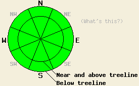
LOW avalanche danger exists on all elevations and aspects. Please use normal caution while traveling in the backcountry. |
|
|
|
The east winds started to weaken yesterday and should continue to decrease over the next 24 hours. A high pressure ridge has established itself over the forecast area and should bring gradually warming temperatures to the region. Daytime highs should reach into the upper 30's and low 40's above 7000 ft today. By tomorrow the daytime highs should rise another 5 to 10 degrees. The forecast calls for clear, sunny skies and continued warming as long as this high pressure persists.
Observations on Rubicon Peak yesterday showed conditions similar to those seen across the forecast area this week. At the lower elevations, frozen melt-freeze crusts existed on all aspects. These frozen crusts extended up to 9000 ft on the W-SW-S-SE aspects. By mid afternoon some very shallow softening did occur on the most sun-exposed slopes. On the N-NE-E aspects above 8800 ft, a firm scoured surface left behind by the strong east winds existed. On the more sheltered N aspects between 7600 ft and 8800 ft, about 4-6 inches of softer snow remained (video). Stability tests and hand pits indicated that the bonds between the old crusts and the more recent snow and the bonds within the recent snow continue to gain strength. These tests and observations also showed that the weak sugary snow (facets) below the old crust has started to round and gain strength.
Avalanche Concerns:
As the snowpack continues to settle and strengthen, avalanche activity due to lingering instabilities in the most recent snow will become more and more unlikely. Wet snow instabilities that form as sunshine and warmer temperatures melt the frozen snow surface will comprise the primary avalanche concern over the next few days. Today these wet snow instabilities should remain small and isolated due to a very strong refreeze that has occurred over the last several days and gradually warming temperatures that should only reach into the upper 30's and low 40's. Some roller balls and wet loose sluffs may start to occur today on the most sun-exposed SE-S-SW aspects. Even though dangerous avalanche activity remains unlikely, it is not impossible. Continue to evaluate slopes carefully before committing to them and travel with caution in the backcountry.
LOW avalanche danger exists on all elevations and aspects. Please use normal caution while traveling in the backcountry.
| 0600 temperature: | 22-24 deg. F. |
| Max. temperature in the last 24 hours: | 24-29 deg. F. |
| Average wind direction during the last 24 hours: | East and Northeast |
| Average wind speed during the last 24 hours: | 30-35 mph |
| Maximum wind gust in the last 24 hours: | 72 mph |
| New snowfall in the last 24 hours: | O inches |
| Total snow depth: | 59-85 inches |
For 7000-8000 ft: |
|||
| Thursday: | Thursday Night: | Friday: | |
| Weather: | Sunny | Clear | Sunny |
| Temperatures: | 35-42 deg. F. | 19-27 deg. F. | 44-50 deg. F. |
| Wind direction: | East | East | Southeast |
| Wind speed: | 15-20 mph with gusts to 35 mph decreasing to 10-15 mph with gusts to 25 mph in the afternoon | around 10 mph after midnight | around 10 mph |
| Expected snowfall: | O in. | O in. | O in. |
For 8000-9000 ft: |
|||
| Thursday: | Thursday Night: | Friday: | |
| Weather: | Sunny | Clear | Sunny |
| Temperatures: | 31-38 deg. F. | 23-29 deg. F. | 36-43 deg. F. |
| Wind direction: | East | Northeast | East shifting to the south in the afternoon |
| Wind speed: | 20-35 mph with gusts to 50 mph deceasing to 10-15 mph with gusts to 25 mph in the afternoon | 10-15 mph | 10-15 mph with gusts to 25 mph in the afternoon |
| Expected snowfall: | O in. | O in. | O in. |


This website is owned and maintained by the non-profit arm of the Sierra Avalanche Center. Some of the content is updated by the USDA avalanche forecasters including the forecasts and some observational data. The USDA is not responsible for any advertising, fund-raising events/information, or sponsorship information, or other content not related to the forecasts and the data pertaining to the forecasts.

