In partnership with: 
|
February 14, 2011 at 7:41 am |
|
Avalanche danger remains LOW for all elevations and aspects. Normal caution is advised. |
|
|
|
A major change in the weather is taking place as the first of several strong weather systems moves into the forecast area. Today's big story will be gale force winds over the higher terrain, mostly cloudy skies, and isolated to scattered snow showers with little to no measurable accumulation. Snow level is expected around 6,000' for today. Ridgetop winds out of the southwest have steadily increased in speed since 10 pm last night with gusts topping 100 mph this morning. These winds have mixed out the air temperature inversion that lingered over the past couple of days and has brought the warmest air down to the mountain valley floors this morning. At this time, no appreciable snowfall is expected during the next 24 hours. A high intensity snowfall event is forecast to begin tomorrow afternoon or evening and continue through Wednesday.
Observations made yesterday near the east end of Echo Lake (Echo Summit area) (pit profile, more info) and along the ridge dividing Poison Canyon and Bee Gulch (Bear Valley area) continued the trend of recent observations from around the forecast area indicating a stable snowpack. Snow surface conditions are a mix of melt-freeze surfaces, wind scoured surfaces, breakable crusts, and some isolated patches of softer snow. The vast majority of daily melt freeze has been focused on sun-exposed SE-S-SW aspects. The exposed N-NE-E aspects near and above treeline hold firm, uneven, wind-scoured surfaces in nearly all areas. Isolated patches of softer snow remain only on the sheltered upper elevation N aspects below treeline. In some but not all areas, this layer is continuing to facet and will be worth monitoring during the upcoming storm cycle. Stability tests and hand pits continue to show a strengthening trend at all other heights within the snowpack. Overall the existing snowpack is in good condition to handle new snow loading from the upcoming storm cycle.
Avalanche concerns:
Avalanche concerns for today are few. Despite the gale force winds occurring at the upper elevations, very little to no snow is available for wind transport. No new slab formation is expected occur until after the onset of significant snowfall sometime tomorrow. Very little to no snow surface melting is expected to occur today on southerly aspects. Maximum daytime air temperatures may or may not climb above freezing today. The very strong to gale force southwest winds will create convective cooling of the snow surface and further limit snow surface melting. In the very unlikely event that snowfall today exceeds forecast amounts, small human triggered slab avalanches would become possible this afternoon in isolated areas on wind loaded N-NE-E aspects.
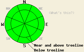
Avalanche danger remains LOW for all elevations and aspects. Normal caution is advised.
| 0600 temperature: | 24 to 28 deg. F. |
| Max. temperature in the last 24 hours: | 39 to 45 deg. F. |
| Average wind direction during the last 24 hours: | Southwest |
| Average wind speed during the last 24 hours: | Prior to 6 pm 22 mph, since 6 pm 45 mph |
| Maximum wind gust in the last 24 hours: | 101 mph |
| New snowfall in the last 24 hours: | O inches |
| Total snow depth: | 57 to 83 inches |
For 7000-8000 ft: |
|||
| Monday: | Monday Night: | Tuesday: | |
| Weather: | Mostly cloudy skies with isolated snow showers in the morning. Scattered snow showers in the afternoon. | Mostly cloudy skies with isolated snow showers. | Mostly cloudy skies with scattered snow showers. |
| Temperatures: | 30 to 38 deg. F. | 21 to 28 deg. F. | 31 to 38 deg. F. |
| Wind direction: | SW | SW | SW |
| Wind speed: | 20 to 30 mph with gusts to 70 mph. Winds increasing to 30 to 40 mph with gusts to 80 mph in the afternoon. | 25 to 40 mph with gusts to 80 mph. | 30 to 45 mph with gusts to 80 mph. |
| Expected snowfall: | 0 to trace in. | 0 to trace in. | Up to 2 in. |
For 8000-9000 ft: |
|||
| Monday: | Monday Night: | Tuesday: | |
| Weather: | Mostly cloudy skies with isolated snow showers in the morning. Scattered snow showers in the afternoon. | Mostly cloudy skies with isolated snow showers. | Mostly cloudy skies with scattered snow showers. |
| Temperatures: | 28 to 36 deg. F. | 21 to 28 deg. F. | 24 to 33 deg. F. |
| Wind direction: | SW | SW | SW |
| Wind speed: | 55 to 75 mph with gusts to 120 mph. | 55 to 75 mph with gusts to 120 mph. | 55 to 75 mph with gusts to 110 mph. |
| Expected snowfall: | 0 to trace in. | 0 to trace in. | Up to 3 in. |


This website is owned and maintained by the non-profit arm of the Sierra Avalanche Center. Some of the content is updated by the USDA avalanche forecasters including the forecasts and some observational data. The USDA is not responsible for any advertising, fund-raising events/information, or sponsorship information, or other content not related to the forecasts and the data pertaining to the forecasts.

