In partnership with: 
|
February 16, 2011 at 8:00 am |
|
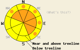
Near and above treeline on slopes steeper than 35 degrees, CONSIDERABLE avalanche danger exists on the NW-N-NE-E-SE aspects. Below treeline on slopes steeper than 35 degrees, MODERATE avalanche danger exists on all aspects with pockets of CONSIDERABLE danger on the NW-N-NE-E-SE aspects. |
|
|
|
A strong winter storm and cold front have brought winter back to the region. Along the Sierra Crest north of Highway 50 and in the Mt. Rose area, 12-14 inches of new snow has fallen since last night. Some sensors on Donner Summit reported up to 19 inches of new snow. Farther south along the crest and in the mountains southeast of Lake Tahoe snow accumulations only total 6-9 inches so far. The winds have averaged 50-60 mph out of the southwest with gusts as high as 117 mph recorded along the Sierra Crest. As the cold front accompanying this storm passes through the forecast area today, the temperatures should fall. Today's highs in the mid 20's should occur early this morning. Snowfall should also continue today with the heaviest precipitation rates occurring this morning. By the end of the day, another 10-22 inches of snow could fall above 7000 ft. After a short break in the storm tonight, a second, weaker wave of winter weather should begin to impact the forecast area tomorrow with continued winds, cold temperatures, and up to another 8 inches of snow expected during the day.
Yesterday, along the Sierra Crest near Carson Pass and on Mt. Judah, the strong southwest winds had taken the 3-6 inches of new snow that had fallen and created stiff wind slabs up to 1.5 ft deep. These stiff wind slabs sat on top of a softer lighter layer of new snow just above the crusts that comprised the old snow surfaces. In Mt. Judah area some stability tests indicated that fractures could occur along this interface (video). Other tests like ski cuts and cornice drops did not produce avalanche activity. In the Carson Pass area where less snow had fallen resulting slabs less deep and less heavy, stability tests and ski cuts did not show as many signs of instability (pit profiles). Overall the storm snow has fallen on a mix of these wind slabs and a thin layer of new snow sitting on top of frozen crusts, scoured surfaces, and patches of old softer snow along the Sierra Crest. On the other side of the lake in the Mt. Rose backcountry, almost no new snow had accumulated by yesterday afternoon, and observations showed no signs of instability in the old snow. In this area the new snow sits directly on top of the frozen crusts, wind scoured surfaces, and patches of old softer snow (photo).
Primary Avalanche Concern: Wind Slabs
Southwest winds combined with new snow have created new wind slabs on the leeward slopes. These slabs will continue to grow today as the winds and snowfall continue. These slabs have formed on top of a variety of crusts, other wind slabs, and softer storm snow which are all potential weak interfaces or weak layers. These slabs have likely formed faster than the bonds between them and those weaknesses. Human-triggered avalanches involving these wind slabs will be likely today, and natural avalanches will be possible as these slabs overload the bonds holding them in place. These slabs could reach several feet in depth and could run long distances in some areas due to the hard bed surfaces that exist beneath them in some starting zones. The wind-loaded N-NE-E and cross-loaded NW and SE aspects hold the best potential for this type of avalanche. These slabs could extend into traditionally sheltered areas and lower elevation slopes due to the strength of the winds over the last 24 hours. Use clues like blowing snow, cornices, drifts, ripples, and other wind created features to tell where wind-loading has occurred.
Avalanche Concern #2: Storm Snow Weaknesses
Even in non-wind-loaded areas, the new snow will still be sitting on top of those potential weaknesses mentioned above. Changes in the temperature, snowfall rate, and other conditions during the storm will also create weaknesses within the storm snow. Human-triggered avalanches that fail due to those storm snow weaknesses or at the base of the storm snow will be possible today. In some areas that receive the most new snow, these kind of avalanches may even be likely, and some natural activity may be possible. Soft slabs should comprise most of these avalanches. Any slopes steeper than 35 degrees with significant new snow hold potential for these types of avalanches. These slides will be more likely north of Hwy 50 where more snow has fallen.
Avalanche Concern #3: Loose Snow Avalanches
Loose snow avalanches will comprise the third avalanche concern for today. Human-triggered sluffs that entrain much of the new cold snow that falls today will be possible on any steep slopes. While these slides are not as likely to bury a person, they could easily push someone into a terrain trap or provide a trigger for a slab avalanche on the slopes below.
Near and above treeline on slopes steeper than 35 degrees, CONSIDERABLE avalanche danger exists on the NW-N-NE-E-SE aspects. Below treeline on slopes steeper than 35 degrees, MODERATE avalanche danger exists on all aspects with pockets of CONSIDERABLE danger on the NW-N-NE-E-SE aspects.
| 0600 temperature: | 19-25 deg. F. |
| Max. temperature in the last 24 hours: | 25-33 deg. F. |
| Average wind direction during the last 24 hours: | Southwest |
| Average wind speed during the last 24 hours: | 55-65 mph |
| Maximum wind gust in the last 24 hours: | 117 mph |
| New snowfall in the last 24 hours: | North of Hwy 50: 12-19 inches, South of Hwy 50: 6-9 inches |
| Total snow depth: | 61-96 inches |
For 7000-8000 ft: |
|||
| Wednesday: | Wednesday Night: | Thursday: | |
| Weather: | Snow in the morning becoming snow showers in the afternoon. Temperatures falling through the day. | Snow showers | Snow likely with the heaviest snow occurring late in the afternoon. |
| Temperatures: | 24-27 deg. F. | 11-16 deg. F. | 18-22 deg. F. |
| Wind direction: | South shifting to the southwest | West | Southwest |
| Wind speed: | 20-30 mph with gusts to 45 mph | 15-25 mph with gusts to 35 mph | 15-25 mph with gusts to 40 mph in the afternoon |
| Expected snowfall: | 10-18 in. | up to 4 in. | up to 6 in. |
For 8000-9000 ft: |
|||
| Wednesday: | Wednesday Night: | Thursday: | |
| Weather: | Snow in the morning becoming snow showers in the afternoon. Temperatures falling through the day. | Snow showers | Snow likely with the heaviest snow occurring late in the afternoon. |
| Temperatures: | 20-24 deg. F. | 6-11 deg. F. | 14-18 deg. F. |
| Wind direction: | South shifting to the southwest | West | Southwest |
| Wind speed: | 50-65 mph with gusts to 100 mph decreasing to 30-50 mph with gusts to 70 mph in the afternoon | 30-50 mph with gusts to 65 mph decreasing to 55 mph after midnight | 25-40 mph with gusts to 60 mph increasing to 40-50 mph with gusts to 80 mph in the afternoon |
| Expected snowfall: | 12-22 in. | 3-6 in. | up to 8 in. |


This website is owned and maintained by the non-profit arm of the Sierra Avalanche Center. Some of the content is updated by the USDA avalanche forecasters including the forecasts and some observational data. The USDA is not responsible for any advertising, fund-raising events/information, or sponsorship information, or other content not related to the forecasts and the data pertaining to the forecasts.

