In partnership with: 
|
February 23, 2011 at 7:58 am |
|
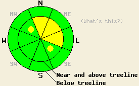
Near and above treeline on slopes steeper than 35 degrees, MODERATE avalanche danger remains on wind-loaded N-NE-E aspects with pockets MODERATE danger on cross-loaded NW and SE aspects. Below treeline avalanche danger is LOW. Large human triggered avalanches remain possible. |
|
|
|
The winds and clouds should start to increase today ahead of a strong, cold winter storm approaching the region. Temperatures should remain in the 20's during the day and only fall into the teens tonight above 7000 ft. By tomorrow the daytime highs should start to cool back down into the teens above 8000 ft and low 20's above 7000 ft. As the storm starts to arrive tomorrow, snow should start falling and become widespread by the afternoon. Due to the late start to the snowfall tomorrow, the forecast only calls for up to 2 new inches before sunset (more information on this storm).
Stronger than forecast winds transported snow and formed new wind slabs on the leeward aspects near and above treeline yesterday (video). In the Mt. Rose backcountry these new, stiff wind slabs ranged from 3-12 inches in depth and from 10's of feet to just a few feet in extent. Most of the slabs only existed near ridgelines on the wind-loaded side of the ridge. These slabs formed on top of other previously formed wind slabs which rested on top of lighter softer snow. Skier-triggered shooting cracks and fractures occurred on slopes where these slabs existed. In some areas these fractures would break at the interface between the previous wind slabs and the lighter snow (upside down snowpack). Stability tests indicated that human-triggered fractures remain possible at this interface (photos and video). These wind slabs formed a firm wind packed snow surface. On more sheltered northerly aspects, soft snow remained on the surface. On the more sun-exposed aspects, a thin breakable crust had formed up to 9500 ft. In most areas sheltered from the winds and in most below treeline areas observations showed a mostly stable snowpack resulting from continued settlement and consolidation.
A third hand report indicated that a large snowmobiler triggered avalanche occurred near Blue Lakes near Carson Pass on Monday. According to the small amount of information received so far, this slide possibly had a 12 ft crown, totaled two snowmobiles, and caused some injuries to one person.
Primary Avalanche Concern: Wind Slabs
As the winds increase today, more wind-loading will create more fragile wind slabs and cornices. These new slabs will help keep the weaknesses below the older wind slabs active. Human-triggered avalanches will remain possible again today on steep, wind-loaded slopes. The most sensitive of the wind slabs will exist in wind loaded complex or extreme terrain. Wind loaded N-NE-E and cross-loaded NW-SE aspects near and above treeline will also provide good locations to find these wind slabs. Many of these wind slabs will exhibit hard slab characteristics. They could be more difficult to trigger, but when they break, they could easily break above the person who triggers them making them more difficult to escape. Larger triggers like the tender cornices looming above many wind-loaded slopes and multiple people on a slope will have better chances of causing avalanche activity. If these wind slabs do fail, they could result in large, deep, and destructive avalanches. Any instabilities that exist will lurk within areas of seemingly stable stable snow. Conservative decision making and careful snowpack evaluation on a slope by slope basis are prudent strategies for today's conditions.
Near and above treeline on slopes steeper than 35 degrees, MODERATE avalanche danger remains on wind-loaded N-NE-E aspects with pockets MODERATE danger on cross-loaded NW and SE aspects. Below treeline avalanche danger is LOW. Large human triggered avalanches remain possible.
| 0600 temperature: | 12-16 deg. F. |
| Max. temperature in the last 24 hours: | 22 deg. F. |
| Average wind direction during the last 24 hours: | West Southwest |
| Average wind speed during the last 24 hours: | 30 mph |
| Maximum wind gust in the last 24 hours: | 55 mph |
| New snowfall in the last 24 hours: | O inches |
| Total snow depth: | 87-116 inches |
For 7000-8000 ft: |
|||
| Wednesday: | Wednesday Night: | Thursday: | |
| Weather: | Mostly cloudy | Mostly cloudy with a chance of snow | Snow becoming widespread by the afternoon |
| Temperatures: | 26-33 deg. F. | 20-25 deg. F. | 21-26 deg. F. |
| Wind direction: | West | Southwest | Southwest |
| Wind speed: | 5-15 mph with gusts to 30 mph increasing to 15-25 mph with gusts to 55 mph in the afternoon | 15-30 mph with gusts to 55 mph | 20-35 mph with gusts 50-70 mph |
| Expected snowfall: | O in. | O in. | up to 2 in. |
For 8000-9000 ft: |
|||
| Wednesday: | Wednesday Night: | Thursday: | |
| Weather: | Mostly cloudy | Mostly cloudy with a chance of snow | Snow becoming widespread by the afternoon |
| Temperatures: | 16-26 deg. F. | 10-20 deg. F. | 11-21 deg. F. |
| Wind direction: | West | Southwest | Southwest |
| Wind speed: | 15-25 mph with gusts to 40 mph increasing to 25-40 mph with gusts to 55 mph in the afternoon | 30-45 mph with gusts to 65 mph | 40-60 mph with gusts to 80 mph |
| Expected snowfall: | O in. | O in. | up to 2 in. |


This website is owned and maintained by the non-profit arm of the Sierra Avalanche Center. Some of the content is updated by the USDA avalanche forecasters including the forecasts and some observational data. The USDA is not responsible for any advertising, fund-raising events/information, or sponsorship information, or other content not related to the forecasts and the data pertaining to the forecasts.

