In partnership with: 
|
February 25, 2011 at 7:53 am |
|
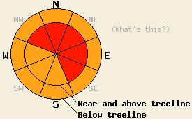
Near and above treeline, avalanche danger is HIGH on NW-N-NE-E-SE aspects 32 degrees and steeper. Below treeline avalanche danger is CONSIDERABLE on all aspects on slopes 35 degrees and steeper. Large destructive avalanches are likely today. |
|
|
|
Snowfall from the current storm system began yesterday morning in the northern portion of the forecast area, but held off until the evening hours in the southern portion of the forecast area. Snowfall totals thus far are ranging 8 to 20 inches with the greatest accumulations along the Sierra Crest from Hwy 88 north. An additional 12 to 24 inches inches of accumulation are expected above 7,000' by the end of today. Air temperatures have been on a warming trend overnight with many remote sensors reporting the warmest air temperatures of the past 24 hours occurring this morning. Air temperatures are expected to remain in the low teens to low 20s today with several degrees of cooling after cold front passage occurs during the mid day hours. Ridgetop winds remain strong to gale force out of the southwest this morning. Continued southwest to west winds with gradual decreases in speed are expected through tonight. Strong gusts are expected to continue during the day today. Much colder air temperatures, snow showers, and northeast winds are forecast for tomorrow.
Observations made yesterday on Carpenter Ridge (Independence Lake area) revealed above forecast snowfall amounts during the day and very significant amounts of drifting snow. Stability test performed along the flank of a slab avalanche 1 to 3 days old in near treeline terrain at 8,600' on a NE aspect 36 to 43 degree slope revealed skier triggered cracking and snowpit tests indicating that fracture along this weak layer remained likely in this area. The slab was composed of higher density wind deposited snow on top of a weak layer of lower density recent storm snow. This is the same upside down snowpack instability that has been observed around the forecast area for the past week. At the other end of the 1 to 3 day old avalanche, skier triggered test slope failure occurred while approaching the slope from the top of the ridge creating a very small slab avalanche with a crown 1 to 1.5 feet deep with the same slab and weak layer characteristics as previously noted (photos, video, more info). On the East Ridge of Ralston Peak (Echo Summit area) snowfall rates were lower, but significant transport of old and new snow still brought visibility down to less than 20' at times, especially during the morning hours before visibility improved and snowfall rates further decreased during the afternoon hours. Hard slabs with hollow sounding drum like characteristics were noted on northerly aspects in this area in near treeline to above treeline terrain at 8,900'. Snowpit data revealed that fracture along lower density recent storm snow at the base of the hard slab remained likely in this area (pit profile, more info).
Kirkwood Professional Ski Patrol reported that several natural avalanches occurred last night in avalanche paths along Hwy 88.
Primary Avalanche Concern: Deep Wind Slabs
Concerns for large destructive avalanches remain focused on unstable winds slabs that existed in wind loaded areas near and above treeline on N-NE-E aspects prior to significant new snowfall last night and today. In many areas these wind slabs have taken on hard slab characteristics which will allow a person to get further out onto the slab before failure occurs or for more than one person to travel the slope before an avalanche occurs. The combination of new snow and ongoing wind loading yesterday and today will further load and stress these already unstable areas. Failure of these wind slabs today will lead to deep slab avalanches failing 1 to 3 feet below the old/new snow interface. Large natural and human triggered avalanches are likely today.
Secondary Avalanche Concern: Storm snow
Continually warming air temperatures during the overnight hours will have placed higher density snow on top of lower density snow at the old/new snow interface. This will create upside down storm snow instabilities in both below treeline and above treeline areas. Any open areas where wind effects occur will further enhance this instability. Both slab and loose snow avalanches are expected today especially in response to human triggers. The amount of wind effect on the slope will determine if the storm snow fails as a slab or as loose snow. Slab avalanches may occur today in many areas with seemingly little wind effect.
Near and above treeline, avalanche danger is HIGH on NW-N-NE-E-SE aspects 32 degrees and steeper. Below treeline avalanche danger is CONSIDERABLE on all aspects on slopes 35 degrees and steeper. Large destructive avalanches are likely today.
| 0600 temperature: | 16 to 21 deg. F. |
| Max. temperature in the last 24 hours: | 16 to 22 deg. F. |
| Average wind direction during the last 24 hours: | Southwest |
| Average wind speed during the last 24 hours: | 57 mph |
| Maximum wind gust in the last 24 hours: | 106 mph |
| New snowfall in the last 24 hours: | 8 to 20 inches |
| Total snow depth: | 92 to 136 inches |
For 7000-8000 ft: |
|||
| Friday: | Friday Night: | Saturday: | |
| Weather: | Cloudy skies with snow. | Cloudy skies with snow. | Cloudy to mostly cloudy skies with snow showers likely in the morning. A chance of snow showers in the afternoon. |
| Temperatures: | 17 to 23 deg. F. | 0 to 5 deg. F. | 10 to 16 deg. F. |
| Wind direction: | SW | W | NW shifting to NE |
| Wind speed: | 15 to 30 mph with gusts 40 to 60 mph. | 10 to 20 mph with gusts to 40 mph. Winds decreasing to 10 to 15 mph overnight. | 5 to 15 mph with gusts to 30 mph in the afternoon. |
| Expected snowfall: | 12 to 20 in. | 4 to 8 in. | Up to 2 in. |
For 8000-9000 ft: |
|||
| Friday: | Friday Night: | Saturday: | |
| Weather: | Cloudy skies with snow. | Cloudy skies with snow. | Cloudy to mostly cloudy skies with snow showers likely in the morning. A chance of snow showers in the afternoon. |
| Temperatures: | 12 to 17 deg. F. | -4 to 3 deg. F. | 4 to 10 deg. F. |
| Wind direction: | SW | SW shifting to W | NW shifting to NE |
| Wind speed: | 45 to 60 mph decreasing to 35 to 50 mph in the afternoon. Gusts to 90 mph. | 20 to 35 mph with gusts to 65 mph. Winds decreasing to 15 to 25 mph with gusts to 40 mph after midnight. | 15 to 20 mph with gusts to 35 mph in the afternoon. |
| Expected snowfall: | 12 to 24 in. | 4 to 8 in. | Up to 2 in. |


This website is owned and maintained by the non-profit arm of the Sierra Avalanche Center. Some of the content is updated by the USDA avalanche forecasters including the forecasts and some observational data. The USDA is not responsible for any advertising, fund-raising events/information, or sponsorship information, or other content not related to the forecasts and the data pertaining to the forecasts.

