In partnership with: 
|
March 1, 2011 at 7:59 am |
|
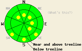
Near and above treeline, very isolated pockets of MODERATE avalanche danger exist on NW-N-NE-E-SE aspects, 37 degrees and steeper. Below treeline, pockets of MODERATE avalanche danger may form on the most sun-exposed SE-S-SW aspects 35 degrees and steeper due to daytime warming. |
|
|
|
The forecast calls for one more day of sunny weather today before a low pressure system quickly moves into the area. Cloud cover should increase ahead of this system during the day today in the form of some thin high clouds. The winds should remain out of the south and southwest and should increase as the system arrives this evening. Snowfall should start tonight and become heavier during tomorrow morning. By tomorrow afternoon snow accumulations could reach 5-12 in above 7000 ft. This system should start to move east of the area tomorrow afternoon and the snowfall and winds should decrease.
The strong southwest winds and cooler daytime highs yesterday kept the snow frozen down to at least 7000 ft on Mt. Judah on the sun-exposed southerly aspects. A frozen, breakable sun crust existed on SE-S-SW aspects up to 8000 ft in this area. Farther south on Meiss Ridge the southerly aspects did soften slightly, and a thinner sun crust had started to form on these aspects. In both of these areas, no evidence of warming instabilities existed yesterday. On the northerly aspects sheltered from the wind and sun, several inches of soft snow remained on the surface. Ski cuts and stability tests in these more sheltered areas on Mt. Judah showed a mostly stable snowpack. At the higher elevations and on slopes more exposed to the winds, some small wind slabs had formed on the N-NE-E aspects. In the Judah area, these wind slabs had just started to form by 2 pm. On Meiss Ridge these slabs formed earlier in the day and were slightly larger (pit and photos). In both areas these slabs had not grown large enough to pose a threat to backcountry travelers.
Avalanche Concern #1: Isolated wind slabs
In most areas the wind slabs leftover from last week's storms have bonded quite well to the snowpack below them, and new wind-loading has not created new wind slabs large enough to overload these bonds. However, the snowpack does not gain strength everywhere all at once, and more wind-loading should occur today. Some isolated pockets of unstable wind slabs may exist in complex or extreme terrain on steep wind-loaded N-NE-E and cross-loaded NW and SE aspects near and above treeline. Even though these slabs may be more difficult to trigger, avalanches resulting from failure of these slabs could be large with serious consequences due to their locations. Larger triggers like large cornices or multiple people on a slope will have better chances of causing avalanche activity.
Avalanche Concern #2: Warming Instabilities
Continued southwest winds, more cloud cover, a strong overnight refreeze, and the fact that the snow has already experienced some warming over the last few days should help keep warming instabilities to a minimum today. However, enough melting may occur on the most sun-exposed, southerly slopes for pockets of these instabilities to remain. Small roller balls and loose snow sluffs should make up most of these warming instabilities; however, very isolated slab avalanche activity will remain possible as well. Open, sun-exposed, mid to low elevation SE-S-SW aspects are the best areas for pockets of warming instabilities to form. Instabilities due to daytime warming are unlikely but not impossible on other less sun-exposed aspects and on higher elevation sun-exposed slopes. Less cloud cover and/or warmer temperatures than forecasted could cause these kinds of instabilities to become more widespread today.
Near and above treeline, very isolated pockets of MODERATE avalanche danger exist on NW-N-NE-E-SE aspects, 37 degrees and steeper. Below treeline, pockets of MODERATE avalanche danger may form on the most sun-exposed SE-S-SW aspects 35 degrees and steeper due to daytime warming.
| 0600 temperature: | 17-19 deg. F. |
| Max. temperature in the last 24 hours: | 21-27 deg. F. |
| Average wind direction during the last 24 hours: | Southwest |
| Average wind speed during the last 24 hours: | 35-45 mph |
| Maximum wind gust in the last 24 hours: | 65 mph |
| New snowfall in the last 24 hours: | O inches |
| Total snow depth: | 89-134 inches |
For 7000-8000 ft: |
|||
| Tuesday: | Tuesday Night: | Wednesday: | |
| Weather: | Thin high clouds increasing over the region | Mostly cloudy with snow developing after midnight | Snow in the morning becoming mostly cloudy with occasional snow showers in the afternoon |
| Temperatures: | 34-40 deg. F. | 25-30 deg. F. | 31-36 deg. F. |
| Wind direction: | Southwest | South | Southwest |
| Wind speed: | 10-20 mph with gusts between 25 mph and 35 mph | 20-35 mph with gusts between 55 mph and 65 mph | 15-30 mph with gusts to 55 mph |
| Expected snowfall: | O in. | up to 2 in. | 3-6 in. |
For 8000-9000 ft: |
|||
| Tuesday: | Tuesday Night: | Wednesday: | |
| Weather: | Thin high clouds increasing over the region | Mostly cloudy with snow developing after midnight | Snow in the morning becoming mostly cloudy with occasional snow showers in the afternoon |
| Temperatures: | 30-34 deg. F. | 23-29 deg. F. | 27-31 deg. F. |
| Wind direction: | Southwest | Southwest | Southwest |
| Wind speed: | 25-35 mph with gusts to 55 mph | 40-60 mph with gusts to 80 mph | 40-60 mph with gusts to 90 mph |
| Expected snowfall: | O in. | up to 2 in. | 5-10 in. |


This website is owned and maintained by the non-profit arm of the Sierra Avalanche Center. Some of the content is updated by the USDA avalanche forecasters including the forecasts and some observational data. The USDA is not responsible for any advertising, fund-raising events/information, or sponsorship information, or other content not related to the forecasts and the data pertaining to the forecasts.

