In partnership with: 
|
March 2, 2011 at 7:56 am |
|
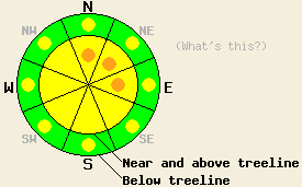
West of Hwy 89, avalanche danger near and above treeline is MODERATE with isolated pockets of CONSIDERABLE danger forming today on N-NE-E aspects on slopes 35 degrees and steeper. Below treeline, avalanche danger is LOW with pockets of MODERATE danger on all aspects on slopes 35 degrees and steeper. East of Hwy 89 avalanche danger is LOW with pockets of MODERATE danger forming today in wind loaded areas near and above treeline on N-NE-E aspects on slopes 35 degrees and steeper. |
|
|
|
The weather system affecting the forecast area this morning will remain focused on the west side of the Sierra Crest today. Limited spillover to the east side of the Sierra Crest is expected at times with the vast majority of precipitation occurring west of Hwy 89. Snow level is expected to remain around 6,000' to 6,500' today. New snow amounts thus far are running 2 to 3 inches along the Sierra Crest above 7,000' with a trace to 1 inch of new snow in the Carson Range. For areas above 7,000', new snow amounts of 4 to 8 inches are expected today along the Sierra Crest decreasing to up to 3 inches east of Hwy 89. Ridgetop winds remain out of the southwest this morning and have increased to strong in speed with gusts around 100 mph at times. A second colder weather system will bring an additional 6 to 12 inches of snowfall to the forecast area tonight into Thursday.
Observations made yesterday on Castle Peak (Donner Summit area) and on Mt. Tallac (Desolation Wilderness area) revealed a mostly stable snowpack. Areas of wind transport were observed during the afternoon hours, but insufficient time had passed for any new wind slabs to form (photos, more info). On Rose Knob Peak (Mount Rose area) again a mostly stable snowpack was observed on the peak with an isolated wind slab instability noted in snowpit data obtained at treeline at 8,840' on a NE aspect with a 41 degree slope angle. The existing wind slab with hard slab characteristics produced very clean shears with test results indicating that fracture along a layer of lower density recent storm snow at the base of the wind slab was likely if failure could be initiated. Given the strength of the hard wind slab, initiating failure of larger sections of slab adjacent to the snowpit was noted as difficult. Minimal to no wet snow instabilities were observed yesterday on SE-S-SW aspects.
Avalanche Concern #1: Storm snow
As the day progresses, areas of storm snow instability are expected to form mainly along the Sierra Crest. Storm snow instabilities may form in the most heavily wind loaded areas in the eastern portion of the forecast area as well. Wind loaded areas near and above treeline will hold the greatest amount of instability with the largest slabs forming on N-NE-E aspects. Human triggered avalanches will be possible today with isolated natural avalanches possible along the Sierra Crest, especially if the upper end of forecast snowfall amounts are reached. Limited rain on snow instabilities may form today mainly in areas that received new snow this morning prior to periods of rising snow levels today.
Avalanche Concern #2: Isolated wind slabs
Ongoing concern exists for isolated hard slab avalanches due to wind slabs that have formed from transport of snow on the ground. This occurred over the weekend and again late yesterday afternoon through last night. Any wind slab failure today is expected to be human triggered. Large triggers such as cornice collapse and multiple people on the slope at once are the most likely triggers for hard slab avalanches today. Due to the hard slab characteristics of the existing wind slabs, just the right trigger point where the slab is thinner will need to be loaded. This could very well allow for more than one person (or several persons) to travel the slope before an avalanche occurs.
West of Hwy 89, avalanche danger near and above treeline is MODERATE with isolated pockets of CONSIDERABLE danger forming today on N-NE-E aspects on slopes 35 degrees and steeper. Below treeline, avalanche danger is LOW with pockets of MODERATE danger on all aspects on slopes 35 degrees and steeper. East of Hwy 89 avalanche danger is LOW with pockets of MODERATE danger forming today in wind loaded areas near and above treeline on N-NE-E aspects on slopes 35 degrees and steeper.
| 0600 temperature: | 26 to 30 deg. F. |
| Max. temperature in the last 24 hours: | 31 to 40 deg. F. |
| Average wind direction during the last 24 hours: | Southwest |
| Average wind speed during the last 24 hours: | 47 mph |
| Maximum wind gust in the last 24 hours: | 108 mph |
| New snowfall in the last 24 hours: | 1 to 3 inches |
| Total snow depth: | 88 to 129 inches |
For 7000-8000 ft: |
|||
| Wednesday: | Wednesday Night: | Thursday: | |
| Weather: | Cloudy skies with occasional snow. | Cloudy skies with occasional snow. | Cloudy skies with snow. |
| Temperatures: | 31 to 38 deg. F. | 21 to 27 deg. F. | 27 to 32 deg. F. |
| Wind direction: | SW | SW | SW |
| Wind speed: | 15 to 30 mph with gusts to 55 mph. | 15 to 25 mph with gusts to 50 mph. Winds decreasing to 10 to 20 mph with gusts to 35 mph after midnight. | 10 to 20 mph with gusts to 35 mph. |
| Expected snowfall: | 2 to 6 in. | 3 to 6 in. | 3 to 6 in. |
For 8000-9000 ft: |
|||
| Wednesday: | Wednesday Night: | Thursday: | |
| Weather: | Cloudy skies with occasional snow. | Cloudy skies with occasional snow. | Cloudy skies with snow. |
| Temperatures: | 25 to 31 deg. F. | 17 to 21 deg. F. | 20 to 25 deg. F. |
| Wind direction: | SW | SW | SW |
| Wind speed: | 40 to 60 mph with gusts to 90 mph. | 30 to 45 mph with gusts to 75 mph. Winds decreasing to 25 to 35 mph with gusts to 60 mph after midnight. | 25 to 35 mph with gusts to 60 mph. |
| Expected snowfall: | 2 to 8 in. | 3 to 6 in. | 3 to 6 in. |


This website is owned and maintained by the non-profit arm of the Sierra Avalanche Center. Some of the content is updated by the USDA avalanche forecasters including the forecasts and some observational data. The USDA is not responsible for any advertising, fund-raising events/information, or sponsorship information, or other content not related to the forecasts and the data pertaining to the forecasts.

