In partnership with: 
|
March 6, 2011 at 8:00 am |
|
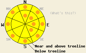
Near and above treeline pockets of CONSIDERABLE avalanche danger may form today on N-NE-E-SE aspects on slopes 35 degrees and steeper. MODERATE danger exists on other near and above treeline aspects. Below treeline pockets of CONSIDERABLE avalanche danger will exist on any slopes steeper than 35 degrees that receive rain today. |
|
|
|
A warm storm system has brought precipitation and strong southwest winds to the forecast area. During the night 2-6 inches of snow fell across the forecast area. Areas east of Lake Tahoe recorded the least amount of snow while Bear Valley and Ebbetts Pass reported the most. Snow level should climb between 6500 ft and 7500 ft during the day today. Many areas near and below 7500 ft should see a mix of rain and snow, while areas above 7500 ft should see mostly heavy, wet snow. Most of the precip should occur this morning and should taper off this afternoon leaving a total of 4-8 inches of snow above 7000 ft. By tonight the forecast calls for a second, colder storm to move into the area. Snow levels should quickly fall back below 6000 ft by Monday morning. The NWS expects another 6-12 inches of snow to accumulate above 7000 ft by tomorrow afternoon. The winds will remain strong during the next 24 hours and should remain out of the west and southwest (weather graphic from the NWS).
Two significant cornice collapses occurred yesterday in the Donner Summit area. One of these cornices failed naturally near the top of Negro Canyon (photo). The other one failed due to a person standing on its edge on the north side of Castle Peak (photo, more info). This person did slide downhill with the cornice for a short distance. When these cornices hit the slopes below, they did not cause any avalanche activity. Farther south on Powderhouse Peak some skier triggered shooting cracks did occur on a steep N facing, wind-loaded test slope (photo, pit). Other N-NE facing wind-loaded slopes near and above treeline in the area also cracked when weighted by a skier. Below treeline on Powderhouse Peak, observations, ski cuts, and stability tests all showed a mostly stable snowpack on the northerly aspects (photo). Some small roller balls did form on sun-exposed E facing slopes below 7800 ft in this area (photo).
Avalanche Concern #1: Wind Slabs
Strong west-southwest winds and new snow have already started to create new wind slabs. As more snow falls today, these slabs will increase in size and extent. By this afternoon they could reach a few feet in depth. Heavy wet snow will make these slabs heavy and dense. They will form on top of older wind slabs some of which still have not bonded to the lighter snow below them as evidenced by yesterday's observations. These new slabs will form quickly and could overload the bonds that hold them to the snowpack. Human triggered avalanches involving the new heavy wind slabs will be likely today. In areas the receive the most new snow and wind-loading some natural avalanches may become possible as well. The wind-loaded N-NE-E and cross-loaded SW aspects near and above treeline will hold the best potential for these avalanches. Avalanches due to wind slab failure could reach several feet in depth in the most wind-loaded areas.
Avalanche Concern #2: Rain on snow
With 2-6 inches of new snow falling last night down to 6500 ft and snow levels forecasted to rise to 7500 ft during the day, many below treeline areas will experience a rain on snow event today. Rain adds weight to the snowpack and weakens it at the same time. It quickly warms the snow up and melts the bonds holding it together. It also lubricates bed surfaces. As the rain falls onto the snowpack today avalanche activity will become possible due to the rain. Some natural avalanches are possible on slopes that receive rain and human-triggered avalanches will be likely on those slopes. Most of these slides should only involve the new snow; however, in areas where the rain can penetrate into older snow that has not seen much warming like the more northerly aspects, deeper avalanches are possible.
Near and above treeline pockets of CONSIDERABLE avalanche danger may form today on N-NE-E-SE aspects on slopes 35 degrees and steeper. MODERATE danger exists on other near and above treeline aspects. Below treeline pockets of CONSIDERABLE avalanche danger will exist on any slopes steeper than 35 degrees that receive rain today.
| 0600 temperature: | 24-28 deg. F. |
| Max. temperature in the last 24 hours: | 33-38 deg. F. |
| Average wind direction during the last 24 hours: | West Southwest |
| Average wind speed during the last 24 hours: | 30-35 mph |
| Maximum wind gust in the last 24 hours: | 58 mph |
| New snowfall in the last 24 hours: | East of Lake Tahoe: 2 inches - Along the Sierra Crest: 4-6 inches |
| Total snow depth: | 91-140 inches |
For 7000-8000 ft: |
|||
| Sunday: | Sunday Night: | Monday: | |
| Weather: | Snow in the morninng decreasing to snow showers in the afternoon. | Snow showers in the evening becoming heavier after midnight. | Snow likely in the morning decreasing to showers in the afternoon. |
| Temperatures: | 35-45 deg. F. | 20-30 deg. F. | 20-30 deg. F. |
| Wind direction: | West | West | West |
| Wind speed: | 25-35 mph with gusts to 60 mph decreasing to 50 mph in the afternoon | 20-30 mph with gusts to 50 mph increasing to 30-40 mph with gusts to 60 mph after midnight | 25-35 mph with gusts to 60 mph |
| Expected snowfall: | up to 3 in. | up to 5 in. | up to 4 in. |
For 8000-9000 ft: |
|||
| Sunday: | Sunday Night: | Monday: | |
| Weather: | Snow in the morninng decreasing to snow showers in the afternoon. | Snow showers in the evening becoming heavier after midnight. | Snow likely in the morning decreasing to showers in the afternoon. |
| Temperatures: | 28-38 deg. F. | 15-25 deg. F. | 14-24 deg. F. |
| Wind direction: | West | West | West |
| Wind speed: | 35-45 mph with gusts to 70 mph decreasing to 55 mph in the afternoon | 35-45 mph with gusts to 60 mph increasing to 70 mph after midnight | 35-45 mph with gusts to 70 mph |
| Expected snowfall: | up to 4 in. | up to 6 in. | up to 5 in. |


This website is owned and maintained by the non-profit arm of the Sierra Avalanche Center. Some of the content is updated by the USDA avalanche forecasters including the forecasts and some observational data. The USDA is not responsible for any advertising, fund-raising events/information, or sponsorship information, or other content not related to the forecasts and the data pertaining to the forecasts.

