In partnership with: 
|
March 9, 2011 at 7:40 am |
|
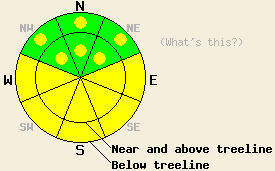
Both above and below treeline, avalanche danger is MODERATE on E-SE-S-SW-W aspects on slopes 35 degrees and steeper. Avalanche danger on NW-N-NE aspects is LOW with pockets of MODERATE danger both above and below treeline. |
|
|
|
A short lived ridge of high pressure will pass through the forecast area today. Decreasing cloud cover, above freezing air temperatures, and light to moderate ridgetop winds are expected for today. Mostly cloudy skies this morning are forecast to give way to partly cloudy skies by this afternoon with air temperatures in the upper 30s to low 50s across the elevation spectrum. Ridgetop winds shifted from west to southwest overnight and will remain out of the southwest through Thursday. By late tomorrow afternoon a storm system passing mainly to the north of the forecast area will bring increased cloud cover, increased winds, and light precipitation to the region.
A couple of human triggered avalanches occurred yesterday under the influence of snow surface warming. On Flagpole Peak (Echo Summit area) a wet loose point release avalanche was skier triggered at 10:30am in near treeline terrain at 8,300' on a NE aspect 40 degrees slope. The avalanche measured 60' at its widest point and ran around 1,600' down slope (more info). A slab avalanche occurred on the Fireplug face near Tamarack Peak (Mount Rose area) sometime between 9am and 11:30am in near treeline terrain at 9,200' on an ESE aspect 38 degree slope. The avalanche measured approximately 75' across and ran 400' down slope. Crown depth was less than 1'. The exact trigger of this avalanche is unknown, but human triggering is expected due to the presence of ski/snowboard tracks along the northern edge of the avalanche (more info).
Observations made on Trimmer Peak (Luther Pass area), on the East Ridge of Tamarack Peak (Mount Rose area), and on Silver Peak (Pole Creek area) revealed minimal to no evidence of instability on northerly aspects despite varying amounts of ongoing wind loading from west winds. Wet surface snow ranging from 1 to 4 inches deep was noted in sun exposed areas on all aspects up to 7,500' to 8,000' by mid day. Wet snow instabilities were noted on Incline Lake Peak (Mount Rose area) up to 9,200' on SE aspects ranging from roller balls to point release wet loose snow sluffs large enough to cause lower extremity injury. (For more info, photos, pit profile, and/or video from these observations, click here.) Widespread melt freeze crusts of varying thickness are expected to have formed overnight in most sun exposed areas below 9,500'.
Avalanche Concern #1: Warming instability
As cloud cover decreases and air temperatures warm to well above freezing in most locations, another round of warming instability will occur today. Much of the instability will occur as roller balls and loose snow point release avalanches, but human triggered slab avalanches remain possible. ENE-E-SE-S aspects that were cross loaded or directly wind loaded by westerly winds over the past three days will be the most suspect. Sun angles are getting higher this time of year which will allow for solar radiation to reach the snow surface in many more locations that just one month ago. Warming instability may occur on northerly aspects today, especially on the sun exposed edges of gully and couloir features.
Avalanche Concern #2: Wind Slabs
Wind slabs have been noted in a number of areas near and above treeline over the past several days. In most areas these wind slabs are stable, but an isolated unstable wind slab capable of contributing to a human triggered avalanche remains possible. Colder, higher elevation N-NE aspects are the most likely location for this to occur. Areas where a more pronounced layer of lower density recent storm snow exists at the base of the wind slab hold the greatest potential for slab failure.
Both above and below treeline, avalanche danger is MODERATE on E-SE-S-SW-W aspects on slopes 35 degrees and steeper. Avalanche danger on NW-N-NE aspects is LOW with pockets of MODERATE danger both above and below treeline.
| 0600 temperature: | 25 to 34 deg. F. |
| Max. temperature in the last 24 hours: | 32 to 44 deg. F. |
| Average wind direction during the last 24 hours: | West |
| Average wind speed during the last 24 hours: | 23 mph |
| Maximum wind gust in the last 24 hours: | 41 mph |
| New snowfall in the last 24 hours: | 0 to trace inches |
| Total snow depth: | 96 to 130 inches |
For 7000-8000 ft: |
|||
| Wednesday: | Wednesday Night: | Thursday: | |
| Weather: | Mostly cloudy skies in the morning, becoming partly cloudy. | Partly cloudy skies. | Partly cloudy skies in the morning. Skies becoming mostly cloudy with rain and snow in the afternoon. |
| Temperatures: | 43 to 52 deg. F. | 25 to 35 deg. F. | 38 to 48 deg. F. |
| Wind direction: | SW | SW | SW |
| Wind speed: | Up to 10 mph. | 10 to 15 mph with gusts to 25 mph. Gusts increasing to 40 mph after midnight. | 20 to 30 mph with gusts to 60 mph. Winds increasing to 30 to 40 mph with gusts to 70 mph in the afternoon. |
| Expected snowfall: | O in. | O in. | 0 to 1 in. |
For 8000-9000 ft: |
|||
| Wednesday: | Wednesday Night: | Thursday: | |
| Weather: | Mostly cloudy skies in the morning, becoming partly cloudy. | Partly cloudy skies. | Partly cloudy skies in the morning. Skies becoming mostly cloudy with snow in the afternoon. |
| Temperatures: | 38 to 48 deg. F. | 20 to 30 deg. F. | 28 to 38 deg. F. |
| Wind direction: | SW | SW | SW |
| Wind speed: | 10 to 20 mph with gusts to 30 mph. | 15 to 25 mph with gusts to 40 mph. Winds increasing to 25 to 35 mph with gusts to 60 mph after midnight. | 30 to 50 mph with gusts to 85 mph. |
| Expected snowfall: | O in. | O in. | Trace to 1 in. |


This website is owned and maintained by the non-profit arm of the Sierra Avalanche Center. Some of the content is updated by the USDA avalanche forecasters including the forecasts and some observational data. The USDA is not responsible for any advertising, fund-raising events/information, or sponsorship information, or other content not related to the forecasts and the data pertaining to the forecasts.

