In partnership with: 
|
March 15, 2011 at 6:51 am |
|
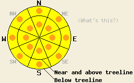
For all aspects and elevations, avalanche danger is MODERATE with pockets of CONSIDERABLE danger forming this afternoon on slopes 35 degrees and steeper. Continued increasing avalanche danger will occur tonight. |
|
|
|
Wet weather is on tap for the forecast area today. A warm storm system will bring rain and snow starting later this morning with snow level forecast to rise to 7,500' to 8,000' today. Rain water amounts of 0.25 to 0.6 inches are expected today. Snow level is forecast to fall to 7,000' tonight and to near 6,000' tomorrow morning. A total of 1 to 3 inches of rain water equivalent is expected to fall over the next 36 hours. Total expected new snow amounts above 7,000' during this time are 8 to 16 inches of heavy wet snow. Ridgetop winds shifted from west to southwest last night ahead of the approaching storm system. Wind speed remains moderate to strong this morning and is forecast to increase to strong in speed tonight before decreasing to moderate is speed tomorrow afternoon.
Observations made yesterday on Tamarack Peak (Mount Rose area) revealed little evidence of storm snow instability during the morning hours. The layering structure of the recent storm snow was noted to have a lower density layer of new snow near the base of the storm snow with higher density snow above. Two weak layers were noted within the storm snow that showed failure in snowpit tests only. By noon evidence of warming instability in the form of skier triggered test slope failure and natural and human triggered roller balls was apparent on E-SE aspects in this area between 8,700' and 9,600'. Fog like cloud cover with occasional sun breaks occurred in this area for most of the day (pit profiles, photos, more info). Observations made on Jake's Peak (West Shore Tahoe area) revealed a similar lower density new snow layer near the base of the storm snow. Observations made in this area on N-NE aspects between 6,800' and 9,000' revealed an overall wetter upper snowpack with two weak layers within the storm snow that showed failure in snowpit tests only. Widespread natural and human triggered roller ball activity was observed along with afternoon warming and rain showers below 8,000' (photo, video, more info).
Primary Avalanche Concern: Rain on snow
As precipitation intensity increases today through tonight, significant amounts of rain will add weight to the upper portion of the recent storm snow in areas below 8,000'. The weak layer of lower density snow identified yesterday near the bottom of the recent storm snow may not have sufficient strength to support the added weight of the expected rain soaked wet snow layer above. Human triggered wet slab avalanche activity is possible today. Natural wet slab avalanches involving the top 6 inches to 2 feet of the snowpack will becoming increasingly possible this afternoon and during the overnight hours.
Secondary Avalanche Concern: Storm snow instability
For areas above the forecast 7,500' to 8,000' snow level, wet and heavy new snow will be deposited on top of the recent storm snow from Sunday night. This will add an additional layer of high density snow to the top of the snowpack, further enhancing the upside down layering characteristics. Unstable slabs of high density snow are expected to form today and tonight, especially near and above treeline in wind loaded areas on N-NE-E aspects. Shallower slabs of storm snow may contribute to human triggered avalanches during the day today, with natural avalanches becoming increasingly possible during the afternoon and overnight hours. Avalanche size potential will increase by late afternoon and continue overnight.
For all aspects and elevations, avalanche danger is MODERATE with pockets of CONSIDERABLE danger forming this afternoon on slopes 35 degrees and steeper. Continued increasing avalanche danger will occur tonight.
| 0600 temperature: | 27 to 32 deg. F. |
| Max. temperature in the last 24 hours: | 32 to 35 deg. F. |
| Average wind direction during the last 24 hours: | West |
| Average wind speed during the last 24 hours: | 46 mph |
| Maximum wind gust in the last 24 hours: | 85 mph |
| New snowfall in the last 24 hours: | Trace to 2 inches |
| Total snow depth: | 98 to 138 inches |
For 7000-8000 ft: |
|||
| Tuesday: | Tuesday Night: | Wednesday: | |
| Weather: | Cloudy skies with a chance of rain and snow in the morning. Rain and snow in the afternoon. Snow level 7,500' to 8,000'. | Cloudy skies with rain and snow in the evening. Snow after midnight. | Cloudy skies with snow in the morning. Snow showers likely in the afternoon. |
| Temperatures: | 40 to 45 deg. F. | 23 to 28 deg. F. | 30 to 34 deg. F. |
| Wind direction: | SW | SW | SW |
| Wind speed: | 10 to 20 mph with gusts to 35 mph. Winds increasing to 20 to 35 mph with gusts to 50 mph in the afternoon. | 20 to 35 mph with gusts to 50 mph. | 20 to 30 mph with gusts to 55 mph. Gusts decreasing to 45 mph in the afternoon. |
| Expected snowfall: | Up to 1 in. | 5 to 10 in. | 3 to 5 in. |
For 8000-9000 ft: |
|||
| Tuesday: | Tuesday Night: | Wednesday: | |
| Weather: | Cloudy skies with a chance of snow in the morning. Snow and rain in the afternoon. | Cloudy skies with snow. | Cloudy skies with snow in the morning. Snow showers likely in the afternoon. |
| Temperatures: | 34 to 40 deg. F. | 24 to 28 deg. F. | 26 to 30 deg. F. |
| Wind direction: | SW | SW | SW |
| Wind speed: | 30 to 45 mph with gusts to 65 mph. Winds increasing to 40 to 60 mph with gusts to 100 mph in the afternoon. | 45 to 65 mph with gusts to 95 mph. | 40 to 60 mph with gusts to 90 mph. Winds decreasing to 25 to 35 mph with gusts to 55 mph in the afternoon. |
| Expected snowfall: | Up to 3 in. | 6 to 11 in. | 3 to 7 in. |


This website is owned and maintained by the non-profit arm of the Sierra Avalanche Center. Some of the content is updated by the USDA avalanche forecasters including the forecasts and some observational data. The USDA is not responsible for any advertising, fund-raising events/information, or sponsorship information, or other content not related to the forecasts and the data pertaining to the forecasts.

