In partnership with: 
|
March 19, 2011 at 7:02 am |
|
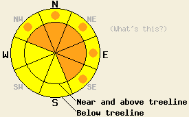
Near and above treeline, CONSIDERABLE avalanche danger exists on NW-N-NE-E-SE aspects steeper than 35 degrees. Below treeline on slopes steeper than 35 degress, pockets of CONSIDERABLE danger exist on those aspects. On the S-SW-W aspects, at all elevations the avalanche danger is MODERATE. Large, deep, and destructive avalanches could occur today. |
|
|
|
Since 2pm yesterday, 15-20 inches of new snow has fallen along the Sierra Crest, and 8-12 inches has accumulated in the mountains east of Lake Tahoe. With this snow the southwest winds averaged 45-55 mph with gusts over 100 mph. These strongest winds occurred along the Sierra Crest. The areas east of Lake Tahoe had slightly less intense winds. Temperatures have fallen consistently during this storm with lows this morning bottoming out in the low teens. As this storm moves out of the area, snowfall should taper off to showers today with only another 2-4 inches of new snow expected above 7000 ft. The wind should also decrease some today. Temperatures should remain cold with daytime highs only climbing into the low 20's. By tonight a second storm should begin to move into the area bringing more snow showers, continued cold temperatures, and increased winds. The bulk of this storm should arrive tomorrow and remain through Sunday night. The forecast calls for another 4-10 inches of new snow above 7000 ft during the day tomorrow. For more information on this storm click here.
Yesterday, strong southwest winds started transporting old snow in the Carson Pass area (photo), the Donner Pass area (video), and in the Mt. Rose area (video) long before the new snow arrived. These winds formed small, stiff wind slabs on top of a layer of lighter, softer snow in the Mt. Rose area. Only one ski cut out of dozens produced cracking on one of the many steep, wind-loaded test slopes in this area. Stability tests on the bonds between these thin new wind slabs and the lighter snow below them in the Rose area did show that fractures could occur at the interface between these two layers (photo, pit profile). Along the Sierra Crest on Stevens Peak and on Donner Summit, this combination of heavy wind slab on top of lighter snow also existed. In these areas ski cuts and cornice drops did not produce any signs of instability on steep, wind-loaded test slopes. Some ski cuts and cornice drops in the Donner Summit area did produce small sluffs in the new snow yesterday afternoon. Snow study sites at Squaw and Alpine this morning showed easy failures within the new snow that has fallen since last night.
Avalanche Concern #1: Wind Slabs
15-20 inches of new snow and strong southwest winds have created large, deep wind slabs on the leeward slopes. The largest wind slabs will exist on the wind-loaded N-NE-E and cross-loaded NW and SE aspects near and above treeline along the Sierra Crest. Smaller but still dangerous wind slabs have formed on lower elevation leeward aspects and in areas where less snow fell. These wind slabs have formed faster than the bonds holding them in place, and in many places they rest on less consolidated weaker snow. Some of the slopes holding the largest wind slabs have likely already avalanched naturally during the night. Today, human-triggered avalanches involving these wind slabs will remain likely, and natural avalanches will remain possible. Large, deep, and destructive avalanches that propagate long distances across slopes and run farther downhill than usual could result from failure of these new wind slabs. They could also step down into older snow.
Avalanche Concern #2: Storm Snow Weaknesses
Subtle changes during the storm have created weaknesses within the storm snow. Human-triggered avalanches resulting from the failure of these weaknesses will be likely today and natural avalanches may be possible in some areas. Failures of these weaknesses could result in soft slab avalanches that entrain enough snow to bury a person or point release avalanches and sluffs. These kinds of avalanches could occur on any steep slope that has a significant amount of new snow on it.
Near and above treeline, CONSIDERABLE avalanche danger exists on NW-N-NE-E-SE aspects steeper than 35 degrees. Below treeline on slopes steeper than 35 degress, pockets of CONSIDERABLE danger exist on those aspects. On the S-SW-W aspects, at all elevations the avalanche danger is MODERATE. Large, deep, and destructive avalanches could occur today.
| 0600 temperature: | 11-15 deg. F. |
| Max. temperature in the last 24 hours: | 19-26 deg. F. |
| Average wind direction during the last 24 hours: | Southwest |
| Average wind speed during the last 24 hours: | 45-55 mph |
| Maximum wind gust in the last 24 hours: | 121 mph |
| New snowfall in the last 24 hours: | East of Lake Tahoe: 8-12 inches; Along the Sierra Crest: 15-20 inches |
| Total snow depth: | 116-174 inches |
For 7000-8000 ft: |
|||
| Saturday: | Saturday Night: | Sunday: | |
| Weather: | Snow showers | Numerous snow showers | Snow |
| Temperatures: | 25-31 deg. F. | 16-23 deg. F. | 25-30 deg. F. |
| Wind direction: | Southwest | South | South shifting to southeast |
| Wind speed: | 15-30 mph with gusts to 55 mph | 10-20 mph with gusts to 40 mph | 15-20 mph with gusts to 45 mph increasing to 25-40 mph with gusts to 60 mph in the afternoon |
| Expected snowfall: | 1-3 in. | 1-3 in. | 4-8 in. |
For 8000-9000 ft: |
|||
| Saturday: | Saturday Night: | Sunday: | |
| Weather: | Snow showers in the morning then numerous snow showers in the afternoon | Numerous snow showers | Snow |
| Temperatures: | 19-25 deg. F. | 14-21 deg. F. | 20-25 deg. F. |
| Wind direction: | Southwest | South | South |
| Wind speed: | 25-35 mph with gusts to 65 mph increasing to 40-60 mph with gusts to 75 mph in the afternoon | 20-35 mph with gusts to 45 mph increasing to gusts to 60 mph | 30-50 mph with gusts to 85 mph increasing to gusts to 100 mph in the afternoon |
| Expected snowfall: | 2-4 in. | 2-4 in. | 5-10 in. |


This website is owned and maintained by the non-profit arm of the Sierra Avalanche Center. Some of the content is updated by the USDA avalanche forecasters including the forecasts and some observational data. The USDA is not responsible for any advertising, fund-raising events/information, or sponsorship information, or other content not related to the forecasts and the data pertaining to the forecasts.

