In partnership with: 
|
March 21, 2011 at 7:00 am |
|
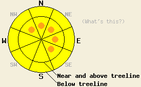
Near and above treeline, avalanche danger is MODERATE with isolated pockets of CONSIDERABLE danger on NW-N-NE-E-SE aspects on slopes 35 degrees and steeper. Below treeline, avalanche danger is MODERATE on all aspects on slopes 35 degrees and steeper. Large destructive avalanches remain possible. Human triggered avalanches are expected today and should not be of surprise to backcountry travelers. |
|
|
|
The storm system that brought high intensity snowfall to the region yesterday has exited the region to the southeast. Significant snowfall continues this morning over the southwestern portion of the forecast area. For the northern and eastern portions of the forecast area, significant snowfall came to an end prior to midnight last night. New snow amounts for the past 24 hours are generally running 10 to 22 inches with some standout locations along the northern portion of the Sierra Crest reporting up to 37 inches. The bulk of this accumulation occurred during the day yesterday, with new snow amounts last night along the Sierra Crest running 5 to 8 inches with around 2 inches overnight in the Carson Range. Ridgetop winds decreased from strong to moderate in speed through the day yesterday and became light for a few hours overnight. Winds remained out of the southwest for most of the last 24 hours, shifting to west and increasing to moderate in speed early this morning. Air temperatures have shown a constant gradual cooling trend overnight.
Yesterday on Powderhouse Peak (Luther Pass area) reports of natural avalanche activity and skier triggered avalanche activity were received. Evidence of fresh but small natural avalanche activity was observed around 10am at 8,900' in wind affected areas below treeline on a N aspect 40 degree convex slope. The avalanche measured 1' deep, 50' wide, and 50' long. A second similar natural avalanche was noted nearby. Debris were soft, broken, and came to rest within a very short distance where terrain features became less steep. The bed surface was noted as a thin layer of denser snow from Saturday's warmer air temperatures. The weak layer was 1mm stellar snow crystals. This party also reported skier triggering a small avalanche very similar in terms of size and terrain to the natural avalanches described above (photos, more info).
Another party on Powderhouse Peak reported a skier triggered avalanche that occurred around 12:45pm at 8,500' in below treeline terrain on a N aspect convex slope of 30 degrees or greater. The avalanche measured 8 to 14 inches deep, 25' wide and 30' long. This party reported triggering shooting cracks on the ascent and on other portions of the descent. Shallow buried debris from an older larger natural avalanche were observed nearby in very similar terrain (photos, more info).
A natural avalanche occurred yesterday on the east side of Highway 89 near the bottom of the Alpine Meadows road in what is known as the Highway Patrol Chute. This avalanche released naturally at 7,200' out of a cross loaded W aspect gully in near treeline terrain with directly wind loaded N-NW aspect wall on the south side of the gully. Visibility was too poor to see the crown from road level, but the avalanche is estimated to have run 1000 vertical feet, measured 75' wide and failed within the storm snow based on knowledge of the avalanche path and other snowpack observations from Saturday and Sunday. Slope angle in this path is greater than 35 degrees. Crown height is unknown. Debris measured 8 feet deep at centerline on the highway. This avalanche path rarely receives explosive control work and had not been controlled yet this season, making it a backcountry snowpack (more info).
Snow pit data submitted this morning by the Kirkwood Professional Ski Patrol from their snow study plot is indicating easy shears 16 to 18 inches deep at the base of the new snow from yesterday.
Avalanche Concern #1: Wind Slabs
As ridgetop winds increase in speed today, additional wind transport is expected to enhance wind slabs that already exist near and above treeline as well as in wind affected areas below treeline. Large and destructive human triggered avalanches are possible to likely today near and above treeline in wind loaded areas with the greatest instability expected on NW-N-NE-E-SE aspects. This concern carries over into wind loaded areas below treeline as well. Isolated natural avalanches remain possible today in the areas of greatest ongoing snowfall, mainly the southwest portion of the forecast area. Once avalanches initiate within the top layers of the storm snow they may step down to deeper weak layers within the storm snow.
Avalanche Concern #2: Storm Snow Weaknesses
Changes in air temperature and snowfall intensity that occurred several times during this storm cycle produced several density changes and storm snow weaknesses. In wind protected areas, a fair amount of settlement is expected to keep ongoing instability greatest within the upper and most recent portions of the new snow that accumulated yesterday. Below treeline in wind protected areas soft slab avalanches and loose snow avalanches are possible in response to human triggers.
Near and above treeline, avalanche danger is MODERATE with isolated pockets of CONSIDERABLE danger on NW-N-NE-E-SE aspects on slopes 35 degrees and steeper. Below treeline, avalanche danger is MODERATE on all aspects on slopes 35 degrees and steeper. Large destructive avalanches remain possible. Human triggered avalanches are expected today and should not be of surprise to backcountry travelers.
| 0600 temperature: | 16 to 20 deg. F. |
| Max. temperature in the last 24 hours: | 20 to 26 deg. F. |
| Average wind direction during the last 24 hours: | Southwest |
| Average wind speed during the last 24 hours: | 22 mph |
| Maximum wind gust in the last 24 hours: | 74 mph |
| New snowfall in the last 24 hours: | 10 to 37 inches |
| Total snow depth: | 126 to 188 inches |
For 7000-8000 ft: |
|||
| Monday: | Monday Night: | Tuesday: | |
| Weather: | Cloudy skies with light snow showers in the morning. Numerous snow showers in the afternoon. | Mostly cloudy skies with a chance of snow showers in the evening. A slight chance of snow showers after midnight. | Mostly cloudy skies. |
| Temperatures: | 22 to 28 deg. F. | 10 to 17 deg. F. | 24 to 31 deg. F. |
| Wind direction: | W | SW | S |
| Wind speed: | 10 to 20 mph with gusts to 35 mph. | 10 to 15 mph with gusts to 30 mph. | 10 to 15 mph with gusts to 25 mph. |
| Expected snowfall: | Up to 2 in. | 0 to trace in. | O in. |
For 8000-9000 ft: |
|||
| Monday: | Monday Night: | Tuesday: | |
| Weather: | Cloudy skies with light snow showers in the morning. Numerous snow showers in the afternoon. | Mostly cloudy skies with a chance of snow showers in the evening. A slight chance of snow showers after midnight. | Mostly cloudy skies. |
| Temperatures: | 19 to 25 deg. F. | 13 to 19 deg. F. | 20 to 28 deg. F. |
| Wind direction: | W | SW | SW |
| Wind speed: | 20 to 30 mph with gusts to 50 mph. | 20 to 30 mph with gusts to 50 mph. Gusts decreasing to 30 mph after midnight. | 10 to 20 mph with gusts to 35 mph. |
| Expected snowfall: | Up to 4 in. | 0 to trace in. | O in. |


This website is owned and maintained by the non-profit arm of the Sierra Avalanche Center. Some of the content is updated by the USDA avalanche forecasters including the forecasts and some observational data. The USDA is not responsible for any advertising, fund-raising events/information, or sponsorship information, or other content not related to the forecasts and the data pertaining to the forecasts.

