In partnership with: 
|
March 23, 2011 at 7:00 am |
|
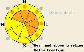
Near and above treeline, CONSIDERABLE avalanche danger will form on NW-N-NE-E-SE aspects on slopes steeper than 35 degrees today. Below treeline pockets of CONSIDERABLE avalanche danger will form on these aspects on slopes steeper than 35 degrees. On the S-SW-W aspects the avalanche danger is MODERATE on slopes steeper than 35 degrees. |
|
|
|
During the night another 3-4 inches of snow fell across the the forecast area as the first of several more storm systems began to approach the area. Temperatures increased a few degrees this morning due to this system pushing some warmer air ahead of it. Snowfall should continue this morning and become more intense this afternoon as this storm arrives. By the end of the day the mountains above 7000 ft could see another foot of new snow with 4-8 more inches tonight. The southerly winds should also increase as this system arrives and shift more to the southwest tonight. As this system moves out of the region tomorrow, a second strong storm should replace it. The forecast calls for periods of intense snowfall (2in/hr or more) and strong southwest winds (gusts to 100 mph over the Crest). When this second storm departs on Thursday another 2-3 ft of snow could have fallen above 7000 ft.
A skier-triggered avalanche occurred on the NE side of the Fireplug in the Mt. Rose backcountry yesterday. The slide carried the skier who triggered it several hundred feet and partially buried him. Fortunately, he only incurred minor injuries. This slide measured about a foot deep. The slab consisted of thin layer of new snow sitting on top of a more dense wind crust and a lighter layer of softer snow below the wind crust. The boundary between that lighter layer of snow at the bottom of the slab and a heavier layer of snow below it represented the weakness that the slide fractured along. This slide occurred on a wind-affected, near treeline, NE facing slope and started as the skier went over a convex roll near the top of the slope (pit profile, photos, and video). Farther south on Mt. Tallac and on Trimmer Peak, similar snowpack structure existed. In both of these areas intentionally triggered avalanches also occurred. They measured 1-2 in depth, but their widths and run-outs were much smaller than the one that occurred in the Mt. Rose area. On Trimmer Peak a skier triggered the avalanche, and on Mt. Tallac a large piece of cornice dropped onto the slope triggered the slide. Some natural avalanches also occurred during the night on Monday or early Tuesday morning that were similar in size to the avalanche mentioned above. Observers on Tallac saw one of these natural slides on the slope next to the one that they dropped the cornice on. In Mt. Rose area, a natural avalanche had occurred on a wind-loaded slope on the far east ridge of Tamarack Peak.
Avalanche Concern #1: Wind Slabs
Human-triggered avalanches will remain likely on wind-loaded slopes today. The old wind slabs have not fully bonded to the snow below them as evidenced by yesterday's avalanches. More new snow and wind forecasted for today will put more weight on top of those old wind slabs by creating new wind slabs above them. As the snow accumulates, triggering these wind slabs will become easier and easier today. Natural avalanche activity will become possible during the day due to the added weight of the new snow. The largest wind slabs will exist on the wind-loaded NW-N-NE-E-SE aspects near and above treeline. Smaller but still dangerous wind slabs could also exist in wind-affected below treeline areas. Avalanches involving these wind slabs could reach several feet in depth and will grow larger and more likely as snow and wind continue over the next few days.
Avalanche Concern #2: Storm Snow Weaknesses
The new snow that falls today will land on top of a mix of snow surfaces ranging from sun-affected snow to soft light snow in non-wind affected areas. Bonding between these layers and the new snow should not occur very quickly. Changing temperatures and winds during the storm will also create other weaknesses withing the new snow. As the new snow accumulates today, human-triggered soft slab avalanches and loose snow sluffs will become likely. These will remain smaller than the wind slabs but may reach up to 1.5 ft in depth. They could easily push someone into an area that has serious consequences or could trap enough snow to bury a person like a stand of trees, over a cliff, into a gully or treewell, or into some other terrain trap. These kind of slides could occur on any steep, open slopes that receive significant new snow today.
Near and above treeline, CONSIDERABLE avalanche danger will form on NW-N-NE-E-SE aspects on slopes steeper than 35 degrees today. Below treeline pockets of CONSIDERABLE avalanche danger will form on these aspects on slopes steeper than 35 degrees. On the S-SW-W aspects the avalanche danger is MODERATE on slopes steeper than 35 degrees.
| 0600 temperature: | 21-26 deg. F. |
| Max. temperature in the last 24 hours: | 22-29 deg. F. |
| Average wind direction during the last 24 hours: | Southwest |
| Average wind speed during the last 24 hours: | 15-30 mph |
| Maximum wind gust in the last 24 hours: | 85 mph |
| New snowfall in the last 24 hours: | 3-4 inches |
| Total snow depth: | 122-188 inches |
For 7000-8000 ft: |
|||
| Wednesday: | Wednesday Night: | Thursday: | |
| Weather: | Snow | Snow | Chance of snow in the morning becoming more widespread in the afternoon |
| Temperatures: | 23-29 deg. F. | 18-23 deg. F. | 20-26 deg. F. |
| Wind direction: | South | Southwest | Southwest |
| Wind speed: | 10-20 mph with gusts to 30 mph increasing to 50 mph in the afternoon | 10-20 mph with gusts to 40 mph | 15-30 mph with gusts to 45 mph increasing to 70 mph in the afternoon |
| Expected snowfall: | 5-10 in. | 4-8 in. | 8-14 in. |
For 8000-9000 ft: |
|||
| Wednesday: | Wednesday Night: | Thursday: | |
| Weather: | Snow | Snow | Chance of snow in the morning becoming more widespread in the afternoon |
| Temperatures: | 20-26 deg. F. | 10-17 deg. F. | 16-22 deg. F. |
| Wind direction: | South | Southwest | Southwest |
| Wind speed: | 15-30 mph with gusts to 50 mph increasing to 25-40 mph with gusts to 70 mph | 20-35 mph with gusts to 60 mph | 35-50 mph with gusts to 70 mph increasing to 40-65 mph with gusts to 100 mph in the afternoon |
| Expected snowfall: | 6-10 in. | 5-8 in. | 8-14 in. |


This website is owned and maintained by the non-profit arm of the Sierra Avalanche Center. Some of the content is updated by the USDA avalanche forecasters including the forecasts and some observational data. The USDA is not responsible for any advertising, fund-raising events/information, or sponsorship information, or other content not related to the forecasts and the data pertaining to the forecasts.

