In partnership with: 
|
March 28, 2011 at 6:57 am |
|
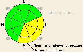
Avalanche danger is MODERATE both above and below treeline on E-SE-S aspects on slopes 35 degrees and steeper. For all other areas avalanche danger is LOW. Please keep in mind that LOW danger does not mean no danger. There is a significant difference between the terms "unlikely" and "impossible". |
|
|
|
High pressure is building over the forecast area today. Partly cloudy skies, above freezing air temperatures, and light to moderate speed west to northwest winds are expected today. This is a significant change from the past few days of 75% to 100% cloud cover, snow showers, and strong to gale force southwest winds. Ridgetop winds that reached gale force again yesterday afternoon with gusts to 127 mph have been steadily decreasing overnight, but remain strong in speed early this morning. Winds are expected to further decrease in speed during the morning hours. New snow amounts for the past 24 hours range from 0 to 1 inch. The northern portion of the forecast area saw 100% cloud cover and snow showers yesterday, while the southern portion saw around 75% cloud cover with little to no snow shower activity.
Observations made yesterday on Red Lake Peak (Carson Pass area) revealed that gale force winds had heavily scoured windward aspects. Lee aspects near ridgelines held firm wind slab with ski penetration less than 1 inch. No signs of instability were observed. Below ridgelines, wind crust and thin slab remained breakable with no propagation observed. Crowns from three natural avalanches were visible just under the summit of Red Lake Peak in above treeline terrain on a N aspect at 9,600'. These avalanches were likely triggered by cornice collapse on Saturday (photo, more info). Strong to gale force winds continued to develop cornices, two of which appeared to have collapsed sometime during the morning hours yesterday and failed to trigger any additional avalanche activity. Winds kept upper elevation southerly aspects cool, but intense solar radiation had warmed mid elevation sun exposed areas at 8,400' to a wet snow surface by late morning.
Observations made yesterday in the Donner Summit area revealed evidence of past natural avalanche activity in lee areas in Negro Canyon, the Donner Pass/Old Hwy 40 area, and in the East Bowl of Mt. Judah. This avalanche activity is thought to have occurred on Saturday. Limited visibility existed at the upper elevations with light snow falling throughout the day accompanied by strong to gale force SW winds (video, more info). The upper snowpack was very wind effected with ski penetration of 0-4''. A density change was noted 2 feet below the snow surface where lighter snow was below the heavier denser wind effected snow. Several hand pits, ski cuts, and cornice drops all showed no signs of propagation on the upper snowpack layers. No evidence of snow surface warming was observed in this area.
Observations made yesterday on Incline Lake Peak (Mount Rose area) revealed a high density wind affected snow surface on all near treeline and below treeline N-NE-E-SE aspects traveled between 8,400' and 9,400'. No evidence of instability was observed in this area despite a noticeable density inversion 1.5 feet deep in the snowpack. Some ongoing wind transport was noted, but no deposition was occurring in avalanche start zones (pit profile, more info). No evidence of snow surface warming was observed in this area.
Ongoing significant settlement of recent storm snow was observed in all areas again yesterday.
Avalanche Concern #1: Warming Instability
As intense late March solar radiation reaches the snow surface in all zones of the forecast area today, areas of warming instability will occur. Instability is expected to focus mainly on E-SE-S aspects at nearly all elevations. The vast majority of SW-W aspects have been thoroughly scoured by gale force winds over the past two days and are not expected to hold much in the way of warming instability today. Significant roller ball activity is expected to occur off of rocks and trees where the wind has not already removed the snow. Areas with greater amounts of wind protection that hold thinner surface slabs or unconsolidated snow will be the most suspect for human triggered slab avalanche activity today under the influence of warming.
Avalanche Concern #2: Wind Slabs
High density wind slabs that have formed in lee areas near and above treeline over the past several days have shown signs of stabilization. Human triggered avalanches involving failure of these hard slabs have become unlikely but not impossible in isolated areas. Continue to use good travel habits and minimize exposure to avalanche run out zones below cornices and other backcountry travelers as clues of instability for these hard slabs will be very few today.
Avalanche danger is MODERATE both above and below treeline on E-SE-S aspects on slopes 35 degrees and steeper. For all other areas avalanche danger is LOW. Please keep in mind that LOW danger does not mean no danger. There is a significant difference between the terms "unlikely" and "impossible".
| 0600 temperature: | 20 to 23 deg. F. |
| Max. temperature in the last 24 hours: | 26 to 32 deg. F. |
| Average wind direction during the last 24 hours: | Southwest shifting to west |
| Average wind speed during the last 24 hours: | 61 mph |
| Maximum wind gust in the last 24 hours: | 127 mph |
| New snowfall in the last 24 hours: | 0 to 1 inches |
| Total snow depth: | 131 to 197 inches |
For 7000-8000 ft: |
|||
| Monday: | Monday Night: | Tuesday: | |
| Weather: | Partly cloudy skies. | Partly cloudy skies. | Partly cloudy skies in the morning, becoming mostly cloudy. |
| Temperatures: | 34 to 41 deg. F. | 19 to 26 deg. F. | 37 to 45 deg. F. |
| Wind direction: | NW | Variable | W |
| Wind speed: | 10 to 15 mph with gusts to 25 mph. | Light winds | Around 10 mph with gusts to 25 mph. Gusts increasing to 35 mph in the afternoon. |
| Expected snowfall: | O in. | O in. | O in. |
For 8000-9000 ft: |
|||
| Monday: | Monday Night: | Tuesday: | |
| Weather: | Partly cloudy skies. | Partly cloudy skies. | Partly cloudy skies in the morning, becoming mostly cloudy. |
| Temperatures: | 25 to 35 deg. F. | 16 to 24 deg. F. | 27 to 37 deg. F. |
| Wind direction: | NW | NE | W |
| Wind speed: | 15 to 25 mph with gusts to 40 mph. | 15 to 25 mph with gusts to 35 mph. | 10 to 20 mph with gusts to 30 mph. Winds increasing to 20 to 30 mph with gusts to 40 mph in the afternoon. |
| Expected snowfall: | O in. | O in. | O in. |


This website is owned and maintained by the non-profit arm of the Sierra Avalanche Center. Some of the content is updated by the USDA avalanche forecasters including the forecasts and some observational data. The USDA is not responsible for any advertising, fund-raising events/information, or sponsorship information, or other content not related to the forecasts and the data pertaining to the forecasts.

