In partnership with: 
|
March 31, 2011 at 7:00 am |
|
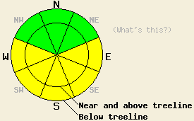
This morning, avalanche danger is LOW for all elevations and aspects. MODERATE avalanche danger will quickly form on E-SE-S-SW-W aspects at all elevations on slopes 35 degrees and steeper due to daytime warming. Large dangerous natural and human-triggered cornice collapses also remain likely today. |
|
|
|
Remote sensors across the region indicate a small inversion with temperatures below 7000 ft colder than those at higher elevations. Most sensors reported temperatures in the 40's through the night and into this morning above 7000 ft. The high pressure ridge over the area should bring lots of sun and more warming to the area today. Daytime highs should climb into the mid 50's above 7000 ft. The winds should continue to decrease and remain light through tomorrow morning. The forecast calls for one more warm day tomorrow; however, some clouds should start to move into the region tomorrow afternoon as a storm begins to approach. The winds should also shift to the southwest and start increasing on Friday ahead of this expected storm.
Yesterday, no evidence of an overnight refreeze existed on Echo Peak by 10 am. In this area 10-14 inches of wet, unconsolidated snow existed on the sun-exposed aspects that faced the southern half of the compass at that time. Below this saturated layer of snow, another 6-8 inches of snow had started to become wet as well (photo). Roller balls had already started to occur on similar aspects. The northerly aspects in this area also had a thin layer of wet snow on them. Ski cuts on test slopes would cause some of the wet snow to move downhill; however, it did not entrain much additional snow or run for long distances. Some large and potentially unstable cornices also still remain above the most wind-loaded slopes in near and above treeline terrain in this area.
Avalanche Concern #1: Warming Instability
Clear skies should have allowed the snowpack to radiate enough heat back out into the night sky for a thin refreeze to occur last night. The warm overnight temperatures should have prevented a deeper and more solid refreeze. Today daytime highs in the 50's, decreased winds, and lots of sunshine will all work together to quickly melt the thin refreeze and allow melting to become more widespread and to penetrate even deeper into the snowpack. As melting occurs, the snowpack will again weaken enough for wet snow instabilities to become possible. Roller balls and wet point releases should comprise most of the wet snow instabilities. Some wet slabs may be possible as well. Glide cracks may also become more obvious in areas where wet snow exists on top of an impermeable surface such as a granite slab. The previously wind-loaded, sun-exposed E-SE-S aspects will hold the best potential for serious wet snow problems; however, these problems could also develop on sun-exposed but wind scoured SW and W aspects today.
Avalanche Concern #2: Wind Slabs and Large Cornice Failure
Natural and human-triggered avalanches involving the old hard wind slabs that formed last week are becoming more unlikely, but still not impossible. If the right trigger impacts the right slope at the right spot some of these slabs may still fail in very, very isolated areas. Very large triggers much larger than a person or a snowmobile could also still cause these dense slabs to fail in more areas. Unfortunately, just such a trigger looms over many of the slopes that have these wind slabs in the form very large cornices that weigh several tons. These heavy cornices remain sensitive to human triggering and could still break naturally especially as the warmer temperatures and sunshine melt the bonds holding them together. Most of these large cornices extend several feet out over the slopes and will break several feet away from their edge. Regardless of whether or not cornice failure causes avalanches on the slopes below, the large pieces of cornice rolling down a slope could easily crush or injure a person standing in their path or tumbling downhill with them. Respect to this potential hazard by staying well away from cornice edges and by lingering on slopes directly below large cornice features. These cornices still exist above several near and above treeline NW-N-NE-E-SE aspects.
This morning, avalanche danger is LOW for all elevations and aspects. MODERATE avalanche danger will quickly form on E-SE-S-SW-W aspects at all elevations on slopes 35 degrees and steeper due to daytime warming. Large dangerous natural and human-triggered cornice collapses also remain likely today.
| 0600 temperature: | 39-48 deg. F. |
| Max. temperature in the last 24 hours: | 49-54 deg. F. |
| Average wind direction during the last 24 hours: | East and northeast |
| Average wind speed during the last 24 hours: | 20-30 mph |
| Maximum wind gust in the last 24 hours: | 72 mph |
| New snowfall in the last 24 hours: | O inches |
| Total snow depth: | 119-185 inches |
For 7000-8000 ft: |
|||
| Thursday: | Thursday Night: | Friday: | |
| Weather: | Sunny | Clear | Sunny in the morning becoming partly cloudy in the afternoon |
| Temperatures: | 52-59 deg. F. | 32-39 deg. F. | 53-60 deg. F. |
| Wind direction: | North | Northeast | Southwest |
| Wind speed: | Light increasing to around 10 mph in the afternoon | 10 mph with gusts to 25 mph | 10-15 mph with gusts to 30 mph in the afternoon |
| Expected snowfall: | O in. | O in. | O in. |
For 8000-9000 ft: |
|||
| Thursday: | Thursday Night: | Friday: | |
| Weather: | Sunny | Clear | Sunny in the morning becoming partly cloudy in the afternoon |
| Temperatures: | 45-54 deg. F. | 33-43 deg. F. | 45-54 deg. F. |
| Wind direction: | North | East | West shifting to the southwest in the afternoon |
| Wind speed: | 10-15 mph with gusts to 30 mph | 10-15 mph with gusts to 25 mph | around 10 in the morning increasing to 20-30 mph with gusts to 40 mph in the afternoon |
| Expected snowfall: | O in. | O in. | O in. |


This website is owned and maintained by the non-profit arm of the Sierra Avalanche Center. Some of the content is updated by the USDA avalanche forecasters including the forecasts and some observational data. The USDA is not responsible for any advertising, fund-raising events/information, or sponsorship information, or other content not related to the forecasts and the data pertaining to the forecasts.

