In partnership with: 
|
April 2, 2011 at 6:46 am |
|
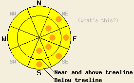
Avalanche danger is MODERATE with pockets of CONSIDERABLE danger below 8,000' on NE-E-SE-S aspects on slopes 35 degrees and steeper. For all other areas, avalanche danger is MODERATE at all elevations on slopes 35 degrees and steeper. |
|
|
|
A weather system will pass by on the eastern side of the forecast area today. Increasing cloud cover late yesterday and overnight has combined with strong west winds to mix out the air temperature inversion and keep air temperatures above freezing last night at all elevations. Air temperatures last night were generally in the 40s below 8,000' and in the upper 30s to low 40s between 8,000' and 9,000'. Very light rain and snow showers may occur at times today with snow level generally around 8,000'. Only a trace of new snow is expected at the upper elevations. Ridgetop winds increased from moderate to strong in speed during the early morning hours. Strong west winds are forecast to continue through today.
Observations made yesterday morning on Red Lake Peak (Carson Pass area) revealed evidence of a good overnight refreeze of the top 6 to 10 inches on the snowpack in open areas from radiational cooling. Evidence of instability in the morning hours was limited to treed areas which lacked a significant refreeze. Skier triggered roller balls and small wet loose avalanches were easy to initiate below 8000ft by 9:30am (more info).
On Tamarack Peak (Mount Rose area) only a minimal overnight refreeze of the top 2 inches of the snowpack occurred in open areas with no refreeze in treed areas. Evidence of instability was minimal during most of the morning, but very quickly developed around 11:30 am. By 11:45 am large roller balls up to 3 feet in diameter occurred in response to ski cuts along the top of the Proletariat Face, an open near treeline E aspect at 9,760'. Wet snow up to 6-8 inches deep was noted in areas of direct sun exposure on E-SE-S aspects traveled between 8,600' and 9,700'. Wet snow on NW-N-NE aspects was minimal and limited to the top 1-2 inches (photos, video, more info). All evidence at mid day indicated significant wet snow instability developing in this area over following 1 to 2 hours.
A small but powerful wet loose snow natural avalanche occurred around 1:30 pm on Highway 89 at Emerald Bay significantly damaging a car. The avalanche occurred on a NE aspect 45 degree slope at 6,800' with moderate tree cover and several rocks, which likely added additional heat to the upper snowpack on the slope. The snowpack failed less than 1 foot deep but was approximately 200' wide and 350' long (photos, more info). The snowpack in this area does not receive explosive avalanche mitigation work and is in a backcountry state.
Primary Avalanche Concern: Warming Instability
Increasing cloud cover last night combined with air temperatures above 40 degrees at the low and middle elevations is expected to have severely limited any amount of overnight refreeze of the snow surface from radiational cooling. Wet surface snow that did not undergo a refreeze last night is expected to exist in nearly all areas below 8,000' this morning. With well above freezing air temperatures and light rain showers expected for today, areas of wet snow instability are expected to exist during the early morning hours and persist all day. Most of the avalanche activity that occurs today is expected as natural or human triggered wet loose snow avalanches, but isolated wet slab avalanches are possible. The greatest areas of instability are expected today on NE-E-SE-S aspects below 8,000', but some amount of instability is expected on all aspects at all elevations until a significant refreeze occurs tonight. Glide cracks are expected to continue to open up in areas where a comparatively shallow snowpack exists over smooth rock slabs in areas that traditionally receive significant sun exposure.
Secondary Hazard: Large Cornice Failure
Sudden collapse of large to very large sections of cornice remains possible today and will continue to present a significant hazard to backcountry travelers. The likelihood that cornice collapse will trigger a slab avalanche on the impacted slope below has becoming increasingly unlikely. However, the large multiple ton pieces of cornice debris falling and sliding down the slope below are sufficient to cause serious injury. In areas where significant wet snow exists on the snow surface, falling cornice debris may entrain significant amounts of wet snow. Stay well back from the edges of cornices, preferably to the areas where exposed rocks are visible sticking up out of the snow surface. Reports of cornice failure up to 30' back from the edge have been received this past week. Avoid stopping or gathering with other backcountry travelers on slopes directly below large cornice features.
Avalanche danger is MODERATE with pockets of CONSIDERABLE danger below 8,000' on NE-E-SE-S aspects on slopes 35 degrees and steeper. For all other areas, avalanche danger is MODERATE at all elevations on slopes 35 degrees and steeper.
| 0600 temperature: | 36 to 41 deg. F. |
| Max. temperature in the last 24 hours: | 52 to 62 deg. F. |
| Average wind direction during the last 24 hours: | West |
| Average wind speed during the last 24 hours: | 38 mph |
| Maximum wind gust in the last 24 hours: | 83 mph |
| New snowfall in the last 24 hours: | O inches |
| Total snow depth: | 110 to 177 inches |
For 7000-8000 ft: |
|||
| Saturday: | Saturday Night: | Sunday: | |
| Weather: | Mostly cloudy skies with scattered rain showers. | Mostly cloudy skies with isolated snow showers in the evening, becoming partly cloudy. | Partly cloudy skies. |
| Temperatures: | 40 to 48 deg. F. | 23 to 29 deg. F. | 35 to 45 deg. F. |
| Wind direction: | SW to W | SW shifting to W | NW shifting to E |
| Wind speed: | 20 to 35 mph with gusts 40 to 60 mph. | 20 to 30 mph with gusts to 55 mph, shifting and decreasing to 10 to 20 mph with gusts to 45 mph after midnight. | 10 to 15 mph. |
| Expected snowfall: | O in. | 0 to trace in. | O in. |
For 8000-9000 ft: |
|||
| Saturday: | Saturday Night: | Sunday: | |
| Weather: | Mostly cloudy skies with scattered snow showers. | Mostly cloudy skies with isolated snow showers in the evening, becoming partly cloudy. | Partly cloudy skies. |
| Temperatures: | 30 to 39 deg. F. | 20 to 26 deg. F. | 30 to 38 deg. F. |
| Wind direction: | SW to W | SW shifting to W | W shifting to NW |
| Wind speed: | 30 to 50 mph with gusts to 90 mph. | 30 to 45 mph with gusts to 60 mph shifting and decreasing to 20 to 35 mph with gusts to 50 mph after midnight. | 15 to 25 mph with gusts to 35 mph shifting and decreasing to 10 to 15 mph in the afternoon. |
| Expected snowfall: | 0 to trace in. | 0 to trace in. | O in. |


This website is owned and maintained by the non-profit arm of the Sierra Avalanche Center. Some of the content is updated by the USDA avalanche forecasters including the forecasts and some observational data. The USDA is not responsible for any advertising, fund-raising events/information, or sponsorship information, or other content not related to the forecasts and the data pertaining to the forecasts.

