In partnership with: 
|
April 4, 2011 at 7:00 am |
|
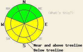
Early this morning, avalanche danger is LOW for all elevations and aspects. MODERATE avalanche danger will form on E-SE-S-SW-W aspects on slopes 35 degrees and steeper as the day warms up. |
|
|
|
A high pressure ridge returned to the area last night. Temperatures briefly dropped below freezing before midnight. After midnight the temperatures climbed back above freezing on their way to daytime highs in the 50's above 7000ft. The forecast even calls for some areas between 7000 ft. and 8000 ft. to approach 60 degrees today. This high pressure should bring another mostly sunny day to the region with only a few scattered clouds. Winds shifted back to the east yesterday and should remain through most of the day. This evening and tonight they should start shifting to the southwest and increasing ahead of a weak low pressure system due to arrive tomorrow. This weak system should only cause slightly cooler temperatures, more widespread clouds, and increased southwest winds.
Yesterday afternoon on Incline Lake Peak, Saturday night's solid refreeze had still not melted all the way. Three to five inches of wet corn snow existed on top of a two to three inch thick frozen melt-freeze crust. By 3:30 pm this wet snow surface had already started to refreeze in this area leaving a thin breakable melt-freeze crust on the surface (pit profile). An hour later at 4:30 enough freezing had occurred for the surface melt-freeze crust to support a skier. Stability tests at this time did not show signs of wet snow instabilities unless additional water was added to the snowpack. Ski cuts also did not produce any roller balls, point releases or other wet snow problems. Large runnels formed last week due to long periods of warming and melting existed on all of the sun-exposed southerly aspects. Several old wet point release avalanches and roller balls also existed (photo).
Primary Avalanche Concern: Warming Instability
Six to eight hours of below freezing temperatures and mostly clear skies last night should have allowed a moderate snowpack refreeze to occur. Since temperatures have already climbed into the 40's at most locations above 7000 ft this morning, this refreeze will start melting quickly as soon as the sun hits the slopes today. With daytime highs in the 50's and possibly 60's at some elevations and plenty of strong April sun, enough melting should occur for wet snow instabilities to form on the sun-exposed E-SE-S-SW-W aspects today. Most of these instabilities should remain limited to wet point release slides and roller balls; however, some wet slab avalanches will become possible today. Glide cracks should also continue to open up on slopes where wet snow exists above an impermeable surface like a granite slab. Use clues like roller balls and boot-top deep wet snow to indicate where wet snow instabilities will be most likely.
Early this morning, avalanche danger is LOW for all elevations and aspects. MODERATE avalanche danger will form on E-SE-S-SW-W aspects on slopes 35 degrees and steeper as the day warms up.
| 0600 temperature: | 38-40 deg. F. |
| Max. temperature in the last 24 hours: | 38-43 deg. F. |
| Average wind direction during the last 24 hours: | East |
| Average wind speed during the last 24 hours: | 20-25 mph |
| Maximum wind gust in the last 24 hours: | 50 mph |
| New snowfall in the last 24 hours: | O inches |
| Total snow depth: | 106-172 inches |
For 7000-8000 ft: |
|||
| Monday: | Monday Night: | Tuesday: | |
| Weather: | Partly cloudy | Partly cloudy | Partly cloudy in the morning becoming mostly cloudy with a slight chance of showers in the afternoon |
| Temperatures: | 52-62 deg. F. | 30-35 deg. F. | 45-54 deg. F. |
| Wind direction: | East shifting to the west | Southwest | Southwest |
| Wind speed: | around 10 mph | around 10 mph | 10-20 mph with gusts to 25 mph increasing to gusts to 40 mph in the afternoon |
| Expected snowfall: | O in. | O in. | O in. |
For 8000-9000 ft: |
|||
| Monday: | Monday Night: | Tuesday: | |
| Weather: | Partly cloudy | Partly cloudy | Partly cloudy in the morning becoming mostly cloudy with a slight chance of showers in the afternoon |
| Temperatures: | 42-52 deg. F. | 33-38 deg. F. | 35-43 deg. F. |
| Wind direction: | East shifting to the west | Southwest | Southwest |
| Wind speed: | 15-25 mph with gusts to 30 mph decreasing to around 10 mph in the afternoon | 10-15 mph with gusts to 30 mph increasing to 15-25 mph with gusts to 40 mph after midnight | 25-40 mph with gusts to 60 mph |
| Expected snowfall: | O in. | O in. | O in. |


This website is owned and maintained by the non-profit arm of the Sierra Avalanche Center. Some of the content is updated by the USDA avalanche forecasters including the forecasts and some observational data. The USDA is not responsible for any advertising, fund-raising events/information, or sponsorship information, or other content not related to the forecasts and the data pertaining to the forecasts.

