In partnership with: 
|
April 5, 2011 at 6:44 am |
|
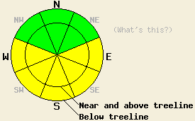
Early this morning, avalanche danger is LOW for all elevations and aspects. MODERATE avalanche danger will form on E-SE-S-SW-W aspects on slopes 35 degrees and steeper as the day warms up. |
|
|
|
After a mostly clear night with temperatures well above freezing, more clouds, wind, and slightly cooler temperatures should affect the region today as a low pressure system moves through the Pacific Northwest. The forecast calls for highs in the low to mid 40's above 8000 ft and in the low 50's below 8000 ft. The winds already shifted to the southwest yesterday, and they have started increasing. Some isolated light showers could also occur this afternoon and evening north of Highway 50. If these shower materialize, some light rain may occur and little to no accumulation is expected. This system should exit the area this evening and allow some clearing before another low pressure starts to move into the forecast area on Wednesday. The forecast calls for cooler temperatures, increased southwest winds, and another increase in cloud cover tomorrow afternoon as the cold front approaches.
By 2pm yesterday, four to eight inches of wet snow existed above a thin, but supportable melt-freeze crust on the E-SE-S-SW-W aspects on Castle Peak (photo). Ski cuts on sun-exposed test slopes between 7400 ft and 8400 ft on these aspects produced small roller balls by 3 pm. The snow also became wet and sticky on these aspects by that time. In many areas the refreeze that occurred Sunday night had almost melted all the way by 3:30 pm. On these sun-exposed aspects large, widespread runnels existed with the troughs of some of the runnels approaching 1 ft in depth (photos). These runnels indicate that the prolonged melting has formed drainage channels that allow water to flow through the snowpack. The northerly aspects in this area also showed signs of warming. Many of these aspects held a combination of melt-freeze crusts and some surface wet snow up to 8200 ft.
Primary Avalanche Concern: Warming Instability
Some refreezing should have occurred last night due to mostly clear skies allowing the snowpack to radiate heat out into space. However, the overnight temperatures above freezing should have tempered this refreeze and not allowed it to progress very deep into the snowpack. As the sun comes out this morning and temperatures climb back into the mid 40's and low 50's today, this refreeze should melt and allow wet snow instabilities to form on the sun-exposed E-SE-S-SW-W aspects again today. Increased winds, slightly cooler daytime highs, and increased cloud cover should keep these instabilities from becoming too large and widespread. Most of these instabilities should remain limited to wet point release slides and roller balls; however, some wet slab avalanches will become possible today. Glide cracks should also continue to open up on slopes where wet snow exists above an impermeable surface like a granite slab. Use clues like roller balls and boot-top deep wet snow to indicate where wet snow instabilities will be most likely.
Early this morning, avalanche danger is LOW for all elevations and aspects. MODERATE avalanche danger will form on E-SE-S-SW-W aspects on slopes 35 degrees and steeper as the day warms up.
| 0600 temperature: | 34-38 deg. F. |
| Max. temperature in the last 24 hours: | 50-56 deg. F. |
| Average wind direction during the last 24 hours: | West southwest |
| Average wind speed during the last 24 hours: | 20 mph |
| Maximum wind gust in the last 24 hours: | 45 mph |
| New snowfall in the last 24 hours: | O inches |
| Total snow depth: | 103-170 inches |
For 7000-8000 ft: |
|||
| Tuesday: | Tuesday Night: | Wednesday: | |
| Weather: | Partly cloudy in the morning becoming mostly cloudy with isolated showers in the afternoon. | Mostly cloudy with isolated showers in the evening then clear after midnight. | Mostly sunny in the morning becoming partly cloudy in the afternoon. |
| Temperatures: | 44-54 deg. F. | 27-32 deg. F. | 34-42 deg. F. |
| Wind direction: | Southwest | Southwest | Southwest |
| Wind speed: | 10-20 mph with gusts to 40 mph increasing to 15-25 mph with gusts to 50 mph in the afternoon | 10-20 mph with gusts to 40 mph decreasing to around 10 mph after midnight | 10-20 mph increasing to 20-35 mph with gusts to 60 mph in the afternoon |
| Expected snowfall: | O in. | O in. | O in. |
For 8000-9000 ft: |
|||
| Tuesday: | Tuesday Night: | Wednesday: | |
| Weather: | Partly cloudy in the morning becoming mostly cloudy with isolated showers in the afternoon. | Mostly cloudy with isolated showers in the evening then clear after midnight. | Mostly sunny in the morning becoming partly cloudy in the afternoon. |
| Temperatures: | 34-44 deg. F. | 23-30 deg. F. | 24-34 deg. F. |
| Wind direction: | Southwest | Southwest shifting to the west after midnight | West |
| Wind speed: | 25-40 mph with gusts to 70 mph | 30-40 mph with gusts to 55 decreasing to 20-30 mph with gusts to 40 mph after midnight | 20-30 mph increasing to 30-45 mph with gusts to 70 mph in the afternoon |
| Expected snowfall: | O in. | O in. | O in. |


This website is owned and maintained by the non-profit arm of the Sierra Avalanche Center. Some of the content is updated by the USDA avalanche forecasters including the forecasts and some observational data. The USDA is not responsible for any advertising, fund-raising events/information, or sponsorship information, or other content not related to the forecasts and the data pertaining to the forecasts.

