In partnership with: 
|
April 6, 2011 at 6:55 am |
|
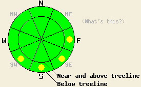
The avalanche danger should remain LOW for most areas today. Some isolated pockets of MODERATE avalanche danger may form on the most sun-exposed, lower elevation E-SE-S-SW aspects on slopes 37 degrees and steeper as the day warms up. As snow and wind impact the forecast area tonight the avalanche danger will quickly increase and become more widespread. |
|
|
|
After some light showers yesterday afternoon, the skies started to clear and remained mostly clear for the rest of the night. Overnight lows also fell below freezing across the forecast area. Clear skies should persist through most of today before a storm system moves into the region this evening. Temperatures should only reach into the mid 30's and mid 40's today above 7000 ft. The southwest winds should increase ahead of this storm during the day. By tonight temperatures should plummet into the teens, and snow should start to fall. The cold temperatures and snow should continue through tomorrow with the heaviest snowfall between midnight and tomorrow morning. By tomorrow afternoon the winds and snow should start to decrease. Tomorrow afternoon could also bring some thunderstorms to the region. The forecast calls for 8-14 inches of new snow by tomorrow afternoon.
On Jake's Peak yesterday, 8-14 inches of wet snow existed on the surface on the E-SE-S-SW aspects below 8500 ft by 2 pm. This wet snow rested on top of a thin melt-freeze crust left over from Monday night. Skier-triggered roller balls did occur on steep E-SE-S facing test slopes below 8500 ft. Large runnels also existed on the sun exposed slopes in this area (photo and pit profile). On the NE-N aspects, three to four inches of wet snow existed on the surface up to 8500 ft. By 2:30 pm the skies had become mostly cloudy. By 3 pm some light precipitation started falling as rain below 8000 ft and light snow above 8000 ft. On Job's Peak only four to six inches of wet saturated snow existed on the surface on NE-E aspects. W-NW winds and more consistent cloud cover seemed to keep the snow in this area more frozen, and observers reported no wet snow instabilities yesterday (more info).
Primary Avalanche Concern: Warming Instability
Below freezing temperatures and clear skies overnight will have allowed a strong refreeze to occur in the snowpack. Cooler daytime highs and increased winds today should help to limit the amount of melting that the strong April sun can achieve. The combination of a strong overnight refreeze and less daytime melting will limit the formation of wet snow instabilities. Some wet snow instabilities may still form on the most sun-exposed, lower elevation E-SE-S-SW aspects today. Most of these instabilities should remain limited to wet point release slides and roller balls. Wet slab avalanches will remain unlikely but not impossible today. Use clues like roller balls and boot-top deep wet snow to indicate where wet snow instabilities will be most likely.
As the winter storm impacts the forecast area this evening, the avalanche danger will rise and become more widespread due to new snow and strong winds.
The avalanche danger should remain LOW for most areas today. Some isolated pockets of MODERATE avalanche danger may form on the most sun-exposed, lower elevation E-SE-S-SW aspects on slopes 37 degrees and steeper as the day warms up. As snow and wind impact the forecast area tonight the avalanche danger will quickly increase and become more widespread.
| 0600 temperature: | 27-30 deg. F. |
| Max. temperature in the last 24 hours: | 39-46 deg. F. |
| Average wind direction during the last 24 hours: | West Southwest |
| Average wind speed during the last 24 hours: | 20 mph |
| Maximum wind gust in the last 24 hours: | 57 mph |
| New snowfall in the last 24 hours: | 0 to a trace inches |
| Total snow depth: | 102-169 inches |
For 7000-8000 ft: |
|||
| Wednesday: | Wednesday Night: | Thursday: | |
| Weather: | Sunny in the morning becoming partly cloudy in the afternoon | Chance of snow in the evening with snow becoming widespread after midnight | Snow in the morning becoming snow showers with a chance of thunderstorms in the afternoon |
| Temperatures: | 35-45 deg. F. | 12-18 deg. F. | 19-25 deg. F. |
| Wind direction: | West | Southwest | Southwest shifting to the west |
| Wind speed: | 10 mph increasing to 20-35 mph with gusts to 55 mph in the afternoon | 20-35 mph with gusts to 60 mph | 15-25 mph with gusts to 50 mph decreasing to 10-20 mph with gusts to 35 mph in the afternoon |
| Expected snowfall: | O in. | 4-8 in. | 4-6 in. |
For 8000-9000 ft: |
|||
| Wednesday: | Wednesday Night: | Thursday: | |
| Weather: | Sunny in the morning becoming partly cloudy in the afternoon | Chance of snow in the evening with snow becoming widespread after midnight | Snow in the morning becoming snow showers with a chance of thunderstorms in the afternoon |
| Temperatures: | 28-35 deg. F. | 9-14 deg. F. | 11-17 deg. F. |
| Wind direction: | West | Southwest | Southwest shifting to the west |
| Wind speed: | 20-30 mph with gusts to 40 mph increasing to 30-45 mph with gusts to 75 mph in the afternoon | 45-60 mph with gusts to 85 mph | 40-55 mph with gusts to 100 mph decreasing to 20-30 mph with gusts to 45 mph in the afternoon |
| Expected snowfall: | O in. | 4-8 in. | 4-6 in. |


This website is owned and maintained by the non-profit arm of the Sierra Avalanche Center. Some of the content is updated by the USDA avalanche forecasters including the forecasts and some observational data. The USDA is not responsible for any advertising, fund-raising events/information, or sponsorship information, or other content not related to the forecasts and the data pertaining to the forecasts.

