In partnership with: 
|
April 7, 2011 at 6:52 am |
|
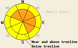
Near and above treeline avalanche danger is CONSIDERABLE on NW-N-NE-E-SE aspects, on slopes 35 degrees and steeper. For all other areas above and below treeline, avalanche danger is MODERATE on all aspects on slopes 35 degrees and steeper. |
|
|
|
The storm system impacting the forecast area today is expected to bring steady snowfall through this morning before decreasing to snow showers through tonight. New snow amounts above 7,000' so far this morning are running 7 to 12 inches across the northern half of the forecast area and 3 to 5 inches across the southern half of the forecast area. An additional 3 to 8 inches of snowfall is expected above 7,000' across the forecast area today. Ridgetop winds are strong in speed out of the west this morning. Winds are expected to shift to the northwest and remain moderate to strong in speed this afternoon. Atmospheric instability this afternoon is expected to create areas of lightning, thunder, and graupel.
Yesterday on the southwest slopes of Mt. Tallac above Lilly Lake (Desolation Wilderness area) significant cloud cover took longer than expected to materialize. With clear skies at mid day, significant solar radiation was melting surface snow more than expected. Snowpit data collected at noon at 8,100' on an open SE aspect 34 degree slope gave early indications of developing wet snow instability. Below 8,100', skier supportable melt freeze conditions with 2 to 6 inches of wet surface snow existed at 12:30pm on southerly aspects. No obvious signs of wet snow instability were present at that time (pit profile, photo, more info).
Primary Avalanche Concern: Storm Snow Instability
With new snow and wind overnight, a shift from wet snow instability concerns to storm snow instability concerns has occurred. Any snowpack failure that occurs today is expected at or above the old/new snow interface. Continually decreasing air temperatures since 5 pm yesterday will have allowed for continually lighter density snow to deposit on top of higher density snow from the start of this storm cycle. This is expected to keep the areas of soft slab avalanche instability focused on wind loaded slopes on NW-N-NE-E-SE aspects. Loose snow avalanches are possible in steep wind protected areas on all aspects, especially if bonding at the old/new snow interface is poor. Natural avalanches are possible today mainly during the morning hours. Human triggered avalanches are possible all day long.
Near and above treeline avalanche danger is CONSIDERABLE on NW-N-NE-E-SE aspects, on slopes 35 degrees and steeper. For all other areas above and below treeline, avalanche danger is MODERATE on all aspects on slopes 35 degrees and steeper.
| 0600 temperature: | 15 to 19 deg. F. |
| Max. temperature in the last 24 hours: | 35 to 44 deg. F. |
| Average wind direction during the last 24 hours: | West |
| Average wind speed during the last 24 hours: | 42 mph |
| Maximum wind gust in the last 24 hours: | 81 mph |
| New snowfall in the last 24 hours: | 3 to 12 inches |
| Total snow depth: | 103 to 172 inches |
For 7000-8000 ft: |
|||
| Thursday: | Thursday Night: | Friday: | |
| Weather: | Cloudy skies with snow in the morning. Numerous snow showers and a slight chance of thunderstorms in the afternoon. | Mostly cloudy skies with scattered snow showers and a slight chance of thunderstorms in the evening. Scattered snow showers after midnight. | Mostly cloudy to cloudy skies with numerous snow showers. |
| Temperatures: | 18 to 24 deg. F. | 4 to 11 deg. F. | 20 to 27 deg. F. |
| Wind direction: | W shifting to NW | N | NE |
| Wind speed: | 15 to 25 mph with gusts to 40 mph. Winds decreasing to 10 to 15 mph with gusts to 25 mph in the afternoon. | 10 to 15 mph with gusts to 45 mph. | 10 to 15 mph with gusts to 40 mph. |
| Expected snowfall: | 3 to 7 in. | Trace to 1 in. | Up to 1 in. |
For 8000-9000 ft: |
|||
| Thursday: | Thursday Night: | Friday: | |
| Weather: | Cloudy skies with snow in the morning. Numerous snow showers and a slight chance of thunderstorms in the afternoon. | Mostly cloudy skies with scattered snow showers and a slight chance of thunderstorms in the evening. Scattered snow showers after midnight. | Mostly cloudy to cloudy skies with numerous snow showers. |
| Temperatures: | 8 to 15 deg. F. | 5 to 11 deg. F. | 17 to 23 deg. F. |
| Wind direction: | W shifting to NW | N | NE |
| Wind speed: | 30 to 50 mph with gusts to 80 mph. Winds decreasing to 30 to 40 mph with gusts to 60 mph in the afternoon. | 25 to 35 mph with gusts to 50 mph. | 20 to 30 mph with gusts to 45 mph. |
| Expected snowfall: | 4 to 8 in. | Trace to 1 in. | Up to 2 in. |


This website is owned and maintained by the non-profit arm of the Sierra Avalanche Center. Some of the content is updated by the USDA avalanche forecasters including the forecasts and some observational data. The USDA is not responsible for any advertising, fund-raising events/information, or sponsorship information, or other content not related to the forecasts and the data pertaining to the forecasts.

