In partnership with: 
|
April 10, 2011 at 6:49 am |
|
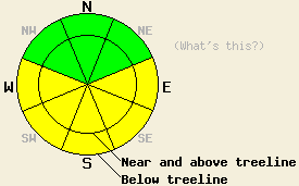
This morning, avalanche danger is LOW for all elevations and aspects. MODERATE avalanche danger may form on open, sun-exposed E-SE-S-SW-W aspects on slopes 35 degrees and steeper as the day warms up. |
|
|
|
Dry weather with warmer temperatures should prevail today due to a high pressure ridge over the area. Light west and southwest winds should accompany this high pressure today. A low pressure moving into the Pacific Northwest should allow some cloud cover to move in this afternoon. The winds and cloud cover should increase tomorrow as this low pressure moves farther inland.
Yesterday, observations on Talking Mountain showed 10-12 inches of light snow resting on top of a hard, frozen, four to six inch thick crust on the N-NE aspects. Layer bonding tests indicated that this recent light snow has bonded to the crust below it. Ski cuts on steep test slopes only produced small loose snow sluffs that entrained the top three inches of the recent snow in this area (photo). Near and above treeline some east wind scouring had occurred on these aspects. On the more southerly aspects a thin, breakable sun crust existed at all elevations. Below this sun crust four to six inches of lighter colder snow remained on these aspects (photo). Tests on these aspects also showed good bonding between the old melt-freeze crust and the new snow above it. Ski cuts on steep SE-S facing slopes did not produce any signs of wet snow instabilities.
Primary Avalanche Concern: Warming Instabilities
The forecast calls for temperatures to climb into the mid to upper 30's above 7000 ft. today. These warmer temperatures combined with the intense April sunshine will allow warmth to penetrate deeper into the snowpack. The most recent snow has not experienced much warming yet and does not have good drainage channels established through it. This layer of unconsolidated recent snow will collect the water that forms as the sun and warmth melt the snow. That water will make this layer heavier and weaker at the same time. Enough melting should occur for some wet snow instabilities to form on the sun-exposed E-SE-S-SW-W aspects during the day. These wet snow instabilities should remain limited to the recent snow above the old melt-freeze crust. Roller balls and wet point release slides should comprise the majority of the wet snow instabilities that form today; however, some wet slab avalanches could also become possible on the most sun-exposed slopes.
This morning, avalanche danger is LOW for all elevations and aspects. MODERATE avalanche danger may form on open, sun-exposed E-SE-S-SW-W aspects on slopes 35 degrees and steeper as the day warms up.
| 0600 temperature: | 16-20 deg. F. |
| Max. temperature in the last 24 hours: | 26-30 deg. F. |
| Average wind direction during the last 24 hours: | West |
| Average wind speed during the last 24 hours: | 15 mph |
| Maximum wind gust in the last 24 hours: | 44 mph |
| New snowfall in the last 24 hours: | O inches |
| Total snow depth: | 104-170 inches |
For 7000-8000 ft: |
|||
| Sunday: | Sunday Night: | Monday: | |
| Weather: | Mostly sunny in the morning becoming cloudy this afternoon | Mostly cloudy | Mostly cloudy |
| Temperatures: | 32-39 deg. F. | 25-31 deg. F. | 39-45 deg. F. |
| Wind direction: | West | Southwest | Southwest |
| Wind speed: | 10 mph | 10-15 mph | 10-20 mph with gusts to 30 mph |
| Expected snowfall: | O in. | O in. | O in. |
For 8000-9000 ft: |
|||
| Sunday: | Sunday Night: | Monday: | |
| Weather: | Mostly sunny in the morning becoming cloudy this afternoon | Mostly cloudy | Mostly cloudy |
| Temperatures: | 32-38 deg. F. | 22-28 deg. F. | 33-39 deg. F. |
| Wind direction: | West | Southwest | Southwest |
| Wind speed: | 10-15 mph with gusts to 30 mph | 15-25 mph with gusts to 35 mph | 20-30 mph with gusts to 55 mph |
| Expected snowfall: | O in. | O in. | O in. |


This website is owned and maintained by the non-profit arm of the Sierra Avalanche Center. Some of the content is updated by the USDA avalanche forecasters including the forecasts and some observational data. The USDA is not responsible for any advertising, fund-raising events/information, or sponsorship information, or other content not related to the forecasts and the data pertaining to the forecasts.

