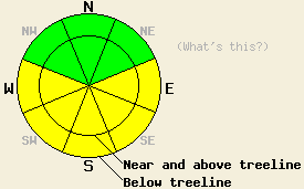
This Avalanche Advisory was published on April 12, 2011:

|
April 12, 2011 at 6:58 am |
|
This morning, avalanche danger is LOW for all elevations and aspects. MODERATE avalanche danger may form on open, sun-exposed E-SE-S-SW-W aspects on slopes 35 degrees and steeper as the day warms up. |
|
|
|
Forecast Discussion:
The forecast calls for a sunny, warm day with daytime highs in the mid to upper 40's above 7000 ft today. The southwest winds should start to increase this evening ahead of a low pressure system approaching the region. This system should remain mostly north of the forecast area but should bring cooler temperatures and increased winds to the central Sierra tonight and Wednesday. A slight chance of some precipitation will also accompany this system on Wednesday. The areas north of Lake Tahoe will have the best chances for snow showers. Little to no accumulation is forecast.
Less warming instabilities occurred yesterday due to the cloud cover, increased winds, and the fact the the snow has now gone through some melt-freeze cycles. On Red Lake Peak, only 2-3 inches of wet snow existed above the old, thick, frozen melt-freeze crust on the E-SE-S aspects up to 9400 ft. This surface snow had almost gone through enough melt-freeze cycles to transition into corn snow in this area. However, it remained wet and sticky in some areas yesterday afternoon. Ski cuts on steep SE-S aspects in this area did not produce any signs of wet snow instabilities, yesterday. Several wet point release slides had occurred on Sunday on E-SE-S aspects on nearby slopes on Carson Pass. Most of these slides remained small and released near exposed cliffs and rocks.
Primary Avalanche Concern: Warming Instabilities
Today's sunshine and air temperatures in the 40's should allow enough melting to occur for more wet snow instabilities to form on sun-exposed E-SE-S-SW-W aspects. These instabilities should again remain limited to the recent snow that is still transitioning from new snow to corn snow. As this transition takes place, more drainage channels will from in this layer of snow allowing the melt water to flow through the snow rather than saturating a specific layer of snow. Since these drainage channels have not completely formed yet, the layer of recent snow will still collect water in some areas as melting occurs today. As the water builds up in this layer, the snow will gain weight and lose strength in these areas. Wet snow instabilities should remain limited to roller balls and wet point release slides. Some wet slab avalanches could also become possible on the most sun-exposed slopes where the recent snow has not fully transitioned into melt-freeze snow. Even though most of the wet snow instabilities that form today should remain relatively shallow, point release or small wet slab avalanches could still push someone off course into terrain traps that could allow someone to get buried or have other serious consequences.
The bottom line:
This morning, avalanche danger is LOW for all elevations and aspects. MODERATE avalanche danger may form on open, sun-exposed E-SE-S-SW-W aspects on slopes 35 degrees and steeper as the day warms up.
Weather Observations from along the Sierra Crest between 8200 ft and 8800 ft:
| 0600 temperature: | 21-27 deg. F. |
| Max. temperature in the last 24 hours: | 35-42 deg. F. |
| Average wind direction during the last 24 hours: | Southwest |
| Average wind speed during the last 24 hours: | 25 mph |
| Maximum wind gust in the last 24 hours: | 44 mph |
| New snowfall in the last 24 hours: | O inches |
| Total snow depth: | 100-166 inches |
Two-Day Mountain Weather Forecast - Produced in partnership with the Reno NWS
For 7000-8000 ft: |
|||
| Tuesday: | Tuesday Night: | Wednesday: | |
| Weather: | Sunny becoming partly cloudy later in the day | Partly cloudy | Mostly cloudy in the morning becoming partly cloudy in the afternoon.Chance of snow showers especially north of Lake Tahoe |
| Temperatures: | 43-53 deg. F. | 19-26 deg. F. | 31-37 deg. F. |
| Wind direction: | Southwest | Southwest | Southwest |
| Wind speed: | 5-15 mph | 10-15 mph with gusts to 30 mph | 10-20 mph with gusts to 40 mph |
| Expected snowfall: | O in. | O in. | trace in. |
For 8000-9000 ft: |
|||
| Tuesday: | Tuesday Night: | Wednesday: | |
| Weather: | Sunny becoming partly cloudy later in the day | Partly cloudy | Mostly cloudy in the morning becoming partly cloudy in the afternoon.Chance of snow showers especially north of Lake Tahoe |
| Temperatures: | 35-45 deg. F. | 17-24 deg. F. | 24-30 deg. F. |
| Wind direction: | Southwest | Southwest | Southwest |
| Wind speed: | 10-15 mph | 15-25 mph with gusts to 40 mph | 20-35 mph with gusts to 60 mph |
| Expected snowfall: | O in. | O in. | trace in. |


