In partnership with: 
|
April 13, 2011 at 6:41 am |
|
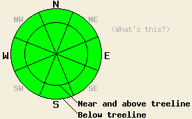
Avalanche danger is LOW for all elevations and aspects. Normal caution is advised. |
|
|
|
A weak weather system will pass through the forecast area today bringing increased cloud cover and scattered snow showers to the region. Little to no snow accumulation is expected. Yesterday, ridgetop winds out of the west southwest exceeded forecast expectations with moderate speed winds rather than light winds. Moderate speed winds continued overnight and are forecast to increase to moderate to strong out of the southwest today. Air temperatures are below freezing at all elevations across the forecast area this morning with temperatures above 8,500' near 20 degrees. Air temperatures above 8,000' are expected to remain below freezing today. Well below freezing air temperatures are forecast for tonight. For tomorrow, decreased cloud cover, moderate speed winds, and above freezing air temperatures at nearly all elevations are expected.
Yesterday, a tour from Sugar Bowl to Squaw Valley along the Sierra Crest revealed minor evidence of wet snow instability. Wet surface snow up to 3 inches deep formed on E-SE-S-SW-W aspects in all areas traveled between 6,200' and 8,700' between 10 am and 2pm. Snow surface conditions remained supportable at 2pm on all aspects with several inches of the remains of the overnight refreeze from Monday night below the wet surface snow. As expected, E-SE-S aspects held the most wet snow while W aspects had only around 1 inch of wet surface snow at 2pm. At 1:50 pm, a very small wet snow sluff occurred in response to a ski cut at treeline at 8,280' on an E aspect slope approximately 40 to 42 degrees in slope angle (photo, more info). North aspects remained a mix of wind scoured ice and unmelted recent storm snow all day. The recent storm snow finished assimilating with the older melt forms yesterday in this area on all but N aspects.
Avalanche concerns:
Avalanche concerns for today are few. With significant cloud cover and air temperatures expected to remain below freezing above 8,000', snow surface melting will be very limited today. Some small amount of snow surface melting is expected to occur on low elevation southerly aspects, but it will occur slowly due to cloud cover and convective cooling from moderate to strong SW winds. Insufficient snow surface melting is expected today to create any areas of wet snow instability.
Scattered snow showers today are not expected to produce more than a trace of new snow accumulation. No storm snow instability is expected today, even in the most heavily wind loaded areas. Only if the current weather forecast is incorrect and new snow amounts of a few inches accumulate today or if the weather system falls apart and allows for decreased cloud cover and warmer air temperatures will more significant avalanche concerns exist for today.
| 0600 temperature: | 19 to 24 deg. F. |
| Max. temperature in the last 24 hours: | 33 to 40 deg. F. |
| Average wind direction during the last 24 hours: | West southwest |
| Average wind speed during the last 24 hours: | 27 mph |
| Maximum wind gust in the last 24 hours: | 52 mph |
| New snowfall in the last 24 hours: | O inches |
| Total snow depth: | 98 to 163 inches |
For 7000-8000 ft: |
|||
| Wednesday: | Wednesday Night: | Thursday: | |
| Weather: | Mostly cloudy skies with scattered snow showers. | Partly cloudy skies with isolated snow showers in the evening. | Partly cloudy skies in the morning, becoming mostly cloudy. |
| Temperatures: | 29 to 35 deg. F. | 13 to 20 deg. F. | 38 to 44 deg. F. |
| Wind direction: | SW | W shifting to SW | SW |
| Wind speed: | 10 to 15 mph with gusts to 45 mph. | 15 to 25 mph with gusts to 40 mph. Winds shifting and decreasing to around 10 mph after midnight. | Up to 10 mph in the morning, increasing to 10 to 15 mph in the afternoon. |
| Expected snowfall: | 0 to trace in. | 0 to trace in. | O in. |
For 8000-9000 ft: |
|||
| Wednesday: | Wednesday Night: | Thursday: | |
| Weather: | Mostly cloudy skies with scattered snow showers. | Partly cloudy skies with isolated snow showers in the evening. | Partly cloudy skies in the morning, becoming mostly cloudy. |
| Temperatures: | 22 to 28 deg. F. | 11 to 18 deg. F. | 32 to 38 deg. F. |
| Wind direction: | SW | W | W |
| Wind speed: | 30 to 45 mph with gusts to 75 mph. | 20 to 35 mph with gusts to 65 mph. | 20 to 30 mph with gusts to 45 mph. |
| Expected snowfall: | 0 to trace in. | 0 to trace in. | O in. |


This website is owned and maintained by the non-profit arm of the Sierra Avalanche Center. Some of the content is updated by the USDA avalanche forecasters including the forecasts and some observational data. The USDA is not responsible for any advertising, fund-raising events/information, or sponsorship information, or other content not related to the forecasts and the data pertaining to the forecasts.

