In partnership with: 
|
April 18, 2011 at 6:49 am |
|
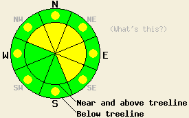
Near and above treeline, MODERATE avalanche danger exists on wind-loaded NW-N-NE-E-SE aspects above 8000 ft. Below 8000 ft. pockets of MODERATE avalanche danger should exist on all aspects due to continued rain on snow. In areas south of Hwy 50 where less precipitation has fallen, the avalanche danger should be less widespread. |
|
|
|
Areas north of Lake Tahoe received the most precipitation last night. Most remote sensors report between .5 and .7 inches of precipitation with a few sensors reporting over one inch. Snow levels started around 9500 ft and dropped to 8000 ft by 1am. By that time most of the precipitation had already fallen as rain. Two to five inches of new snow has accumulated above 8000 ft in areas north of Lake Tahoe since 1 am. South of Lake Tahoe only .2 - .5 inches of precipitation has occurred with only one to three inches of snow accumulating above 8000 ft since 1 am. Snow levels have continued to fall and have dropped to between 7000 ft and 7500 ft this morning. Snow levels should remain around 7500 ft today and some light snow showers should continue with up to four more inches of snow accumulating today. Areas south of Hwy 50 should see less precipitation today. This storm also caused the southwest wind to increase throughout the forecast area. They have averaged between 45 and 55 mph with gusts as high as 117 mph along the exposed ridge-tops over the last 24 hours. These winds should decrease some today as the storm begins to move east. By tonight the snow showers come to an end and the winds should decrease dramatically as a high pressure ridge starts to build over the area. This ridge should cause a partly sunny and warm day tomorrow with temperatures in the mid to upper 40's above 7000 ft.
On Maggie's Peak, Jake's Peak, and Incline Lake Peak, soft, wet snow existed on top of a thick, strong layer of melt-freeze snow by mid-day yesterday. On Maggie's Peak four to six inches of wet snow existed, and some skier triggered roller balls and wet snow sluffs occurred on the southerly aspects (pit profile). Skiers also reported wet snow sluffs and roller balls on the south aspects of Jake's Peak. None of these instabilities entrained enough snow to bury a person, but they were large enough to knock someone off course. Widespread cloud cover did not appear over these areas till after 2pm. On Incline Lake Peak, cloud cover had already increased by noon. In this area less melting occurred and the wet snow instabilities that formed remained much smaller (photos). Only four inches of wet snow formed on the surface in this area by noon. Due to rain and warm temperatures last night the layer of wet snow most likely did not start refreezing until last night's precipitation changed to snow. This timing likely allowed for good bonds to form between the new snow and old snow surfaces.
Avalanche Concern #1: Wind Slabs
Strong winds and dense snow above 8000 ft will have created heavy wind slabs on the leeward slopes. These wind slabs will continue to grow in depth and extent today as more snow accumulates and the winds continue. Even though snow totals have remained relatively small, two to three foot deep wind slabs could exist in wind-loaded areas today. The added weight of a person could also cause these wind slabs to break loose resulting in avalanche activity. Human triggered avalanches will be possible on wind-loaded N-NE-E aspects and cross-loaded NW and SE aspects near and above 8000 ft where more snow has fallen. South of Hwy 50 where less snow has fallen these wind slabs will remain limited to the most wind loaded areas. Most avalanches involving these wind slabs should only involve the new snow.
Avalanche Concern #2: Rain on snow
Warm temperatures and rain during the night should have prevented any freeze from occurring below 8000 ft. As rain continues to fall below 7500 ft today, it will add weight to the snowpack and weaken the snowpack by causing continued melting. Fortunately the snowpack has undergone several melt-freeze cycles allowing allowing drainage channels to form though the snowpack. These drainage channels will help keep the added water from saturating a specific layer of the snowpack. Still the rain should add enough water and cause enough melting for wet snow instabilities to continue on all aspects in areas below the rain snow line. Most of these should remain limited to roller balls and wet point release slides; however, some wet slab avalanches may be possible in areas that have received the most rain and where rain continues to fall today.
Near and above treeline, MODERATE avalanche danger exists on wind-loaded NW-N-NE-E-SE aspects above 8000 ft. Below 8000 ft. pockets of MODERATE avalanche danger should exist on all aspects due to continued rain on snow. In areas south of Hwy 50 where less precipitation has fallen, the avalanche danger should be less widespread.
| 0600 temperature: | 24-29 deg. F. |
| Max. temperature in the last 24 hours: | 41-49 deg. F. |
| Average wind direction during the last 24 hours: | Southwest |
| Average wind speed during the last 24 hours: | 45-55 mph |
| Maximum wind gust in the last 24 hours: | 117 mph |
| New snowfall in the last 24 hours: | Before 1am rain: .3-.8 inches - After 1am snow: 2-5 inches |
| Total snow depth: | 92-160 inches |
For 7000-8000 ft: |
|||
| Monday: | Monday Night: | Tuesday: | |
| Weather: | Snow showers. Snow level 7500 ft. | Mostly cloudy with a chance of snow showers in the evening becoming partly cloudy with a slight chance of snow showers after midnight. | Partly cloudy |
| Temperatures: | 37-40 deg. F. | 20-27 deg. F. | 46-52 deg. F. |
| Wind direction: | Southwest | Southwest | Southwest |
| Wind speed: | 20-30 mph with gusts to 55 mph | 15-25 mph with gusts to 45 mph decreasing to 10-15 mph after midnight | 10-15 mph with gusts to 30 mph in the morning increasing to gusts to 45 mph in the afternoon |
| Expected snowfall: | up to 2 in. | trace in. | O in. |
For 8000-9000 ft: |
|||
| Monday: | Monday Night: | Tuesday: | |
| Weather: | Snow showers. | Mostly cloudy with a chance of snow showers in the evening becoming partly cloudy with a slight chance of snow showers after midnight. | Partly cloudy |
| Temperatures: | 35-41 deg. F. | 21-27 deg. F. | 39-45 deg. F. |
| Wind direction: | Southwest | Southwest shifting to the West after midnight | Southwest |
| Wind speed: | 30-50 mph with gusts to 90 mph | 25-35 mph with gusts to 70 mph decreasing to 15-25 mph with gusts to 55 mph after midnight | 15-25 mph with gusts to 35 mph increasing to 50 mph in the afternoon |
| Expected snowfall: | up to 4 in. | trace in. | O in. |


This website is owned and maintained by the non-profit arm of the Sierra Avalanche Center. Some of the content is updated by the USDA avalanche forecasters including the forecasts and some observational data. The USDA is not responsible for any advertising, fund-raising events/information, or sponsorship information, or other content not related to the forecasts and the data pertaining to the forecasts.

