In partnership with: 
|
April 22, 2011 at 6:41 am |
|
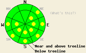
Early this morning, avalanche danger is LOW for all elevations and aspects. Pockets of MODERATE danger will form at all elevations on NE-E-SE-S-SW-W aspects on slopes 35 degrees and steeper in response to daytime warming. |
|
|
|
A short lived break in the weather will occur today before more light rain and snow move into the forecast area this evening. Increasing high level clouds this morning will lower to mid level clouds by the afternoon. Remote sensors are reporting below freezing air temperatures this morning across the forecast area. Sufficient sunshine during the morning hours is expected to allow air temperatures to warm to above freezing at nearly all elevations. Ridgetop winds have decreased in speed overnight and shifted to the south. Winds are forecast out of the south to southwest today and will become moderate in speed. Once precipitation starts again either late this afternoon or this evening, snow level is forecast at 6,000' to 7,000'. A couple of inches of new snow are possible above 8,000'.
Observations made yesterday morning on Tamarack Peak (Mount Rose area) revealed new snow amounts above 9,000' of up to 6 inches with areas of wind loading to just over 1 foot deep. Good bonding to the melt freeze crust at the old snow surface was observed. By 11am, rapid settlement of the new snow had occurred in sun exposed areas on E-SE aspects. Slower settlement but still some increasing density of the lower portion of the new snow was observed on N-NE aspects. Skier triggered cracking was isolated to the small newly formed cornice caps and no more than 2 feet in length. Not much evidence of crack propagation was observed in this area (pit profile, more info).
Observations made yesterday afternoon on Flagpole Peak (Echo Summit area) noted widespread wet snow. Around 2 inches of very wet new snow sat on top of wet old snow at 8,200'. No significant free water pooling was noted in the top 3 feet of the snowpack. A trace to 1 inch of new snow accumulated during the day which formed a light melt freeze crust in shaded areas by mid afternoon. In areas of direct sun exposure small wet loose snow sluffs involving the new snow were easy to initiate, but they did not fan out or entrain much additional snow (photos, more info). A number of glide cracks have recently opened in this area which is known to have numerous granite slabs.
Primary Avalanche Concern: Wet Snow Instability
A strong refreeze of the snow surface is expected to have occurred last night at all elevations. Thin cloud cover this morning will allow for a period of rapid warming and snow surface melting. Increased cloud cover by the afternoon hours is expected to slow snow surface melting late in the day. In areas below 7,500' typical melt freeze conditions will exist due to a lack of significant new snow in the past few days. Above 8,000', the snowpack remains transitional with new snow from Wednesday night not yet assimilated into the melt freeze layer. NE-E aspects above 8,000' hold to greatest potential for sizable wet snow avalanches. Wet snow instability that occurs today is expected mainly in the form of human triggered wet loose snow sluffs in steep terrain. Natural and human triggered wet slab avalanches are unlikely but not impossible in isolated areas at any elevation on top of smooth rock slabs and near glide cracks.
Secondary Avalanche Concern: Storm Snow Instability
Recent new snow has bonded well to the old snow surface. Areas above 8,000' hold up to 1 foot of wind loaded recent storm snow on N-NE-E aspects. No significant weak layers have been observed either within the new snow or at the old/new snow interface. Human triggered slab avalanches involving the recent new snow are unlikely today. However, an isolated human triggered slab avalanche is not impossible in an area where the snowpack differs from recent observations.
Early this morning, avalanche danger is LOW for all elevations and aspects. Pockets of MODERATE danger will form at all elevations on NE-E-SE-S-SW-W aspects on slopes 35 degrees and steeper in response to daytime warming.
| 0600 temperature: | 23 to 26 deg. F. |
| Max. temperature in the last 24 hours: | 30 to 38 deg. F. |
| Average wind direction during the last 24 hours: | Southwest |
| Average wind speed during the last 24 hours: | 30 mph |
| Maximum wind gust in the last 24 hours: | 63 mph |
| New snowfall in the last 24 hours: | Trace to 2 inches |
| Total snow depth: | 93 to 159 inches |
For 7000-8000 ft: |
|||
| Friday: | Friday Night: | Saturday: | |
| Weather: | Increasing clouds with a slight chance of snow by late afternoon. | Cloudy skies with a chance of snow. | Mostly cloudy to cloudy skies with a chance of snow. |
| Temperatures: | 40 to 46 deg. F. | 22 to 29 deg. F. | 38 to 44 deg. F. |
| Wind direction: | S to SW | W | SW |
| Wind speed: | 5 to 10 mph with gusts to 25 mph. | Around 10 mph with gusts to 25 mph in the evening, becoming light. | 10 to 15 mph with gusts to 25 mph in the afternoon. |
| Expected snowfall: | 0 to trace in. | Up to 1 in. | 0 to trace in. |
For 8000-9000 ft: |
|||
| Friday: | Friday Night: | Saturday: | |
| Weather: | Increasing clouds with a slight chance of snow by late afternoon. | Cloudy skies with a chance of snow. | Mostly cloudy to cloudy skies with a chance of snow. |
| Temperatures: | 30 to 35 deg. F. | 19 to 27 deg. F. | 32 to 38 deg. F. |
| Wind direction: | S to SW | SW | SW |
| Wind speed: | 10 to 20 mph with gusts 30 to 40 mph. | 10 to 20 mph with gusts to 40 mph. | 15 to 25 mph with gusts to 35 mph. |
| Expected snowfall: | 0 to trace in. | Up to 2 in. | 0 to trace in. |


This website is owned and maintained by the non-profit arm of the Sierra Avalanche Center. Some of the content is updated by the USDA avalanche forecasters including the forecasts and some observational data. The USDA is not responsible for any advertising, fund-raising events/information, or sponsorship information, or other content not related to the forecasts and the data pertaining to the forecasts.

