In partnership with: 
|
November 21, 2011 at 7:54 am |
|
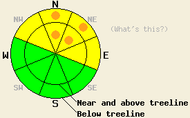
On NW-N-NE-E aspects, the avalanche danger remains MODERATE both above and below treeline in areas above 8,000 ft on slopes 32 degrees and steeper. Some pockets of CONSIDERABLE danger where human-triggered avalanches remain likely still exist on N-NE aspects in these areas. In other areas, the avalanche danger is LOW. |
|
|
|
After another 3-6 inches of snow fell during the morning yesterday, the snow showers started to taper off and most of the snowfall ended by yesterday afternoon. This recent series of storms added about 12-22 inches of new snow to the forecast area since Thursday night. The south to southwest winds remained relatively light during the last 24 hours. A small, high-pressure ridge over the region should bring warmer temperatures and clearer skies to the area through Wednesday. By tomorrow afternoon, the southwest winds should increase dramatically ahead of a low-pressure system expected to arrive over the forecast area late Wednesday.
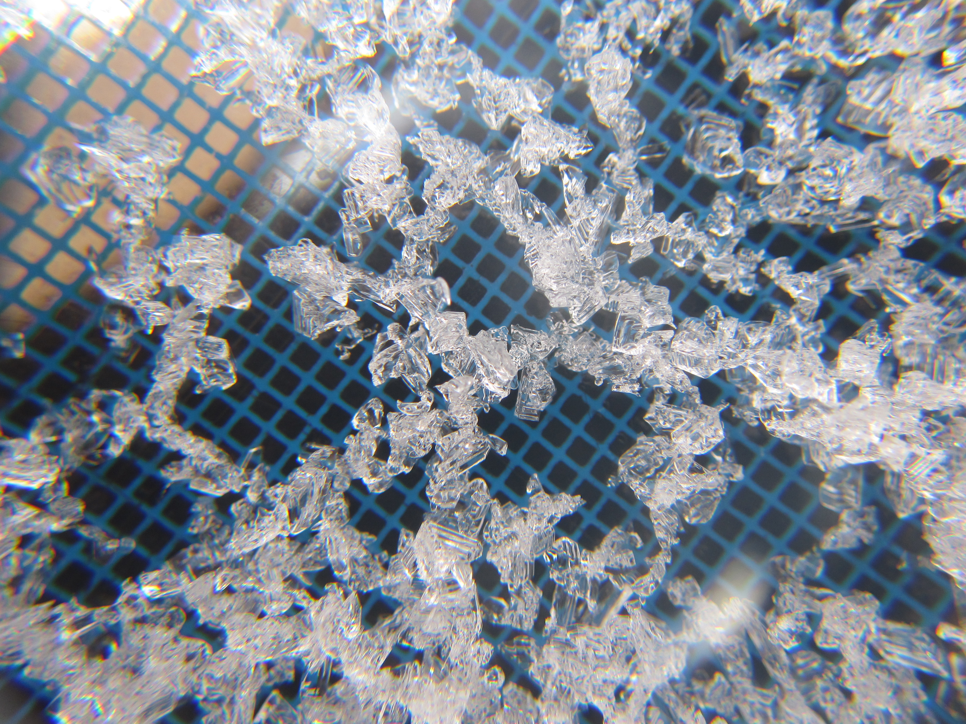
The Nov. 18th facet layer remains weak and brittle. Even though only 10-12 inches of cold and light new snow fell in the Mt. Rose area, widespread skier-triggered whumpfs and shooting cracks (photo) occurred on N-NE aspects above 8600 ft and on some E aspects above 9000 ft. in the Tamarack Peak area yesterday. The added weight of a person caused that layer of weak sugary snow to break and collapse in these areas. Snowpit tests also indicated that once this layer breaks, fractures can travel along the top of this faceted layer in a variety of locations between 8,600 ft. and 9,900 ft. on N-NE-E aspects (more info, video, photos, and snowpit). Recent observations from around the forecast area indicate that the weakest and most well developed facets exist on northerly aspects above 8,000 ft (more info here).
Avalanche Concern: Persistent slabs
As the new snow starts to consolidate over the next few days, it will gain strength. Unfortunately, the persistent weak layer (the Nov 18th facet layer) underneath it will not. So as the new snow becomes stronger it will also become a more cohesive slab that can allow fractures travel farther creating larger avalanche activity trigger-able from farther away. In wind-loaded areas, larger and deeper slabs already exist on top of the snowpack. On slopes where the Nov 18th facets exist, the snowpack remains weak just waiting for a trigger to cause the facet layer to collapse. Avalanches resulting from the failure of this weak layer would likely involve all of the new snow. In areas where snow exists from either last winter or the October 4th-6th storm, an ice layer has formed underneath the facets providing a more efficient bed surface that will allow wider and farther traveling avalanches to occur. Luckily, the persistent weak layer does not exist everywhere. Recent observations indicate that this layer will most likely live on NW-N-NE-E aspects above 8000 ft. Even though the likelihood of natural avalanches has diminished, dangerous human-triggered avalanches remain likely on slopes above and below treeline today especially on the N-NE aspects where the weakest Nov 18th facets exist.
Early season conditions exists out there. A cold, shallow, and weak snowpack represents unusual conditions for this region. Also snow coverage still remains patchy. Until more snow falls, snow travel means dodging shallowly buried rocks, logs, trees, and other knee-breaking, track-tearing, ski/board-destroying obstacles. The combination of an unstable and shallow snowpack warrants extra caution when traveling in the backcountry.
On NW-N-NE-E aspects, the avalanche danger remains MODERATE both above and below treeline in areas above 8,000 ft on slopes 32 degrees and steeper. Some pockets of CONSIDERABLE danger where human-triggered avalanches remain likely still exist on N-NE aspects in these areas. In other areas, the avalanche danger is LOW.
| 0600 temperature: | 19-23 deg. F. |
| Max. temperature in the last 24 hours: | 28 deg. F. |
| Average wind direction during the last 24 hours: | South to Southwest |
| Average wind speed during the last 24 hours: | 10-15 mph |
| Maximum wind gust in the last 24 hours: | 27 mph |
| New snowfall in the last 24 hours: | 3-6 inches |
| Total snow depth: | 14-30 inches |
For 7000-8000 ft: |
|||
| Monday: | Monday Night: | Tuesday: | |
| Weather: | Partly cloudy | Partly cloudy | Partly cloudy |
| Temperatures: | 30-35 deg. F. | 25-32 deg. F. | 36-43 deg. F. |
| Wind direction: | Southwest | Southwest | Southwest |
| Wind speed: | 10-15 mph with gusts to 30 mph | around 10 mph with gusts to 30 mph | 10-15 mph with gusts to 40 mph |
| Expected snowfall: | O in. | O in. | O in. |
For 8000-9000 ft: |
|||
| Monday: | Monday Night: | Tuesday: | |
| Weather: | Partly cloudy | Partly cloudy | Partly cloudy |
| Temperatures: | 25-32 deg. F. | 19-28 deg. F. | 32-37 deg. F. |
| Wind direction: | Southwest | Southwest | Southwest |
| Wind speed: | 15-25 mph with gusts to 40 mph | 20-35 mph with gusts to 55 mph | 25-40 mph with gusts to 75 mph |
| Expected snowfall: | O in. | O in. | O in. |


This website is owned and maintained by the non-profit arm of the Sierra Avalanche Center. Some of the content is updated by the USDA avalanche forecasters including the forecasts and some observational data. The USDA is not responsible for any advertising, fund-raising events/information, or sponsorship information, or other content not related to the forecasts and the data pertaining to the forecasts.

