In partnership with: 
|
December 1, 2011 at 8:00 am |
|
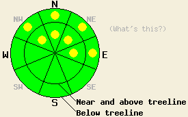
On NW-N-NE-E aspects above 8,000', pockets of MODERATE avalanche danger remain both above and below treeline on slopes 35 degrees and steeper. LOW avalanche danger exists in on all other areas. |
|
|
|
Yesterday the northeast winds increased throughout the forecast area. Wind speeds averaged 45 mph to 60 mph with gusts as high as 90 mph during the last 24 hours along the Sierra Crest. These northeast winds should increase again today and remain strong through this evening due to a low pressure system southeast of the region. Temperatures should remain cold today with daytime highs only reaching into the teens above 7000 ft. Cold temps combined with hurricane force winds means wind chill values of -5 to -15 in the mountains today. By tomorrow the winds should start to decrease, and temperatures could climb back into the 20's and 30's above 7000 ft.
On Ralston Peak yesterday, gale force winds out of the northeast transported significant amounts of snow from the N-NE-E aspects over the crest onto the W-SW-S aspects. These winds even ripped large pieces of the surface crust off of the snowpack and carried them over the ridge (videos). Other observations around the forecast area this week have shown that the Nov 18th facet layer remains weak. Where this layer is weakest, human triggered shooting cracks, collapses, and whumpfing continue to occur. Snowpit tests consistently show that fractures can travel along this layer even in areas where it is less weak. On slopes where rocks, stumps, logs, and other anchors poke through these facets, this layer represents less of a concern. Of course, recreating on these slopes remains difficult due to those same anchors. On a more positive note, some observations indicate that the snow above this weak layer has also weakened. With less strength this overlying snow represents less of a slab. Therefore, the overlying slab falls apart before fractures that start in the Nov. 18th facets can travel very far.
A combination of variable wind, rain and frozen melt-freeze crusts exist on the snow surface in most areas. Northerly aspects sheltered from the wind above 9000 ft represent the exception, and they may still hold some softer snow.
Avalanche Concern #1: Persistent slabs
As the winds continue to scour snow away from the northerly aspects and the snow above the Nov 18th facets continues to weaken, the slabs above this persistent weak layer will decrease in size and extent at least until the next storm. This decrease in slab size and distribution will decrease the areas where slab avalanche activity remains possible; however, some pockets of terrain still exist with slabs on top of the weak Nov. 18th facets. The N-NE aspects above 8000 ft. that hold the most snow represent the areas where the thickest and weakest facets exist under the largest slabs. Unfortunately, these slope also represent better recreation potential. In areas with a very shallow snowpack, where the winds have scoured the slab away, or where the slab has weakened to the point that it is no longer a slab fractures in the weak layer should not travel very far.
The Nov, 18th facets will likely still exist as a persistent weak layer in the forecast area for a prolonged period of time. This layer could take weeks to months to stabilize on its own. Layers like this often need to be physically removed by melting, by avalanche activity, or by scouring. The strong NE winds may scour these facets away in some areas but not everywhere. Once new snow returns to the forecast area in significant amounts, this weak layer should start to reactivate allowing avalanche activity to occur due to its failure to support new snow loads.
On NW-N-NE-E aspects above 8,000', pockets of MODERATE avalanche danger remain both above and below treeline on slopes 35 degrees and steeper. LOW avalanche danger exists in on all other areas.
| 0600 temperature: | 11-14 deg. F. |
| Max. temperature in the last 24 hours: | 36 deg. F. |
| Average wind direction during the last 24 hours: | North northeast |
| Average wind speed during the last 24 hours: | 45-60 mph |
| Maximum wind gust in the last 24 hours: | 90 mph |
| New snowfall in the last 24 hours: | O inches |
| Total snow depth: | 6-22 inches |
For 7000-8000 ft: |
|||
| Thursday: | Thursday Night: | Friday: | |
| Weather: | Sunny and windy with wind chill values below zero | Clear and windy with wind chill values below zero | Partly cloudy in the morning becoming sunny by the afternoon |
| Temperatures: | 18-25 deg. F. | 11-18 deg. F. | 26-36 deg. F. |
| Wind direction: | Northeast | Northeast | Northeast |
| Wind speed: | 30-50 mph with gusts to 70 mph | 30-40 mph with gusts to 60 mph decreasing to 15-20 mph with gusts to 40 mph after midnight | 10-15 mph with gusts to 30 mph |
| Expected snowfall: | O in. | O in. | O in. |
For 8000-9000 ft: |
|||
| Thursday: | Thursday Night: | Friday: | |
| Weather: | Sunny and windy with wind chill values -5 to -15 | Clear and windy with wind chill values -5 to -15 | Partly cloudy in the morning becoming sunny by the afternoon |
| Temperatures: | 13-20 deg. F. | 12-19 deg. F. | 24-34 deg. F. |
| Wind direction: | Northeast | Northeast | Northeast |
| Wind speed: | 55-75 mph with gusts to 95 mph - ridgetop gusts could exceed 100 mph | 45-65 mph with gusts to 95 mph decreasing to 30-50 mph with gusts to 80 mph after midnight | 25-45 mph with gusts 60-70 mph |
| Expected snowfall: | O in. | O in. | O in. |


This website is owned and maintained by the non-profit arm of the Sierra Avalanche Center. Some of the content is updated by the USDA avalanche forecasters including the forecasts and some observational data. The USDA is not responsible for any advertising, fund-raising events/information, or sponsorship information, or other content not related to the forecasts and the data pertaining to the forecasts.

