In partnership with: 
|
December 5, 2011 at 7:35 am |
|
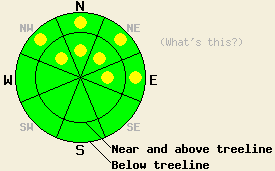
Very isolated pockets of MODERATE danger may remain above 8,000' on NW-N-NE-E aspects both above and below treeline on slopes 35 degrees and steeper. LOW avalanche danger exists for all other areas. |
|
|
|
A weather system passing to the east of the forecast area caused increased northeast winds overnight. Moderate to strong winds are expected to continue through this morning before diminishing this afternoon. Sunny skies with a slight cool down of air temperatures is expected for today. Overnight winds have worked to mix out the air temperature inversion. Remote sensors along the Sierra Crest around 8,500' are reporting air temperatures this morning in the low to mid teens.
Recent observations from around the forecast area including those made yesterday in the Carson Pass area revealed that the recent east winds have scoured significant amounts of snow off of N-NE-E aspects in near and above treeline areas (photos, pit profile, more info). The biggest factor effecting the amount of snow scouring has been the presence or absence of the surface rain crust that formed on Thanksgiving day along the Sierra Crest below 9,000'. These areas have been more resistant to scouring, loosing only moderate amounts of snow (photo, more info). Most parts of the Carson Range where the rain crust did not form, lost significant amounts of snow with many avalanche start zones stripped of snow down to bare ground (photo, more info).
In some areas, the November 18 facet layer is now capped by a strong hard slab that is stable in areas with sufficient anchoring. In other areas, the Nov 18 layer has been physically removed by wind scouring. In areas more protected from the recent east winds, the instability that existed during the second half of November from the combination of the weak facet layer under a slab of storm snow has decreased. This is due to faceting and weakening of the overlying slab to the point that it has become too weak to sustain significant propagation of fractures within the snowpack. Where it still exists, the Nov 18 facet layer remains weak. The change in structure of the overlying slab has decreased the likelihood of slab avalanche activity for now in most areas.
Avalanche Concerns: Persistent slabs
Areas where avalanche activity remains possible have become increasingly isolated. Most areas either have a slab without the proper characteristics for propagation, sufficient anchoring, or have had most or all of the snowpack removed by wind. The terrain most likely to hold any remaining isolated pockets of instability is the same terrain that holds the best potential for over snow recreation. This is the poorly anchored above and below treeline NW-N-NE-E aspects that are above 8000 ft. Slopes with unanchored hard slabs overlying the Nov 18 facet layer hold the greatest potential for destructive avalanches. Any areas of instability will likely exist within greater areas of seemingly stable snow.
Very isolated pockets of MODERATE danger may remain above 8,000' on NW-N-NE-E aspects both above and below treeline on slopes 35 degrees and steeper. LOW avalanche danger exists for all other areas.
| 0600 temperature: | 12 to 15 deg. F. |
| Max. temperature in the last 24 hours: | 30 to 39 deg. F. |
| Average wind direction during the last 24 hours: | northeast |
| Average wind speed during the last 24 hours: | 45 mph |
| Maximum wind gust in the last 24 hours: | 81 mph |
| New snowfall in the last 24 hours: | O inches |
| Total snow depth: | 6 to 20 inches |
For 7000-8000 ft: |
|||
| Monday: | Monday Night: | Tuesday: | |
| Weather: | Sunny skies. | Clear skies. | Sunny skies. |
| Temperatures: | 29 to 34 deg. F. | 18 to 23 deg. F. | 34 to 39 deg. F. |
| Wind direction: | E | E | E |
| Wind speed: | 10 to 20 mph with gusts to 35 mph. Winds decreasing to 10 to 15 mph in the afternoon. | Up to 10 mph. | Up to 10 mph. |
| Expected snowfall: | O in. | O in. | O in. |
For 8000-9000 ft: |
|||
| Monday: | Monday Night: | Tuesday: | |
| Weather: | Sunny skies. | Clear skies. | Sunny skies. |
| Temperatures: | 26 to 31 deg. F. | 16 to 21 deg. F. | 30 to 37 deg. F. |
| Wind direction: | E | E | E |
| Wind speed: | 25 to 40 mph with gusts to 70 mph. Winds decreasing to 20 to 30 mph with gusts to 50 mph in the afternoon. | 10 to 20 mph with gusts to 35 mph. | 10 to 15 mph |
| Expected snowfall: | O in. | O in. | O in. |


This website is owned and maintained by the non-profit arm of the Sierra Avalanche Center. Some of the content is updated by the USDA avalanche forecasters including the forecasts and some observational data. The USDA is not responsible for any advertising, fund-raising events/information, or sponsorship information, or other content not related to the forecasts and the data pertaining to the forecasts.

