In partnership with: 
|
December 20, 2011 at 8:00 am |
|
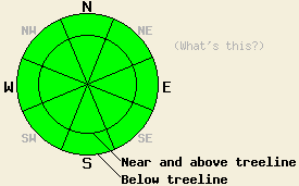
Avalanche danger remains LOW at all elevations and on all aspects. Use normal caution when traveling in the backcountry. |
|
|
|
High pressure returns to the forecast area. The forecast calls for the winds to decrease, skies to clear, and temperatures to rise. Expect to see daytime highs in the mid to upper 30's in the mountains today. Currently an inversion has settled over some of the more enclosed valleys with temperatures at the lower elevations in the single digits and teens in many areas. Meanwhile temperatures in the low 20's exist above 7000 ft. Another weak, dry cold front should pass through the area tomorrow bringing a few clouds, increased north winds, and colder temperatures back to the region.
Yesterday on Tamarack Peak, observations showed a shallow snowpack with a myriad of anchors protruding through it on the more sheltered NW-N-NE-E aspects. This feeble and patchy snowpack consisted entirely of large weak facets or those same facets capped by a thin wind crust. Strong winds earlier this fall had scoured all of the snow away from the more exposed aspects like the Hourglass and Proletariat. Across the forecast area, similar conditions exist. Slightly more snow remains on the northerly aspects along the Sierra Crest north of I80. Almost no snow exists on any of the southerly aspects. Faceting has weakened all of the layers in the snowpack to the point that only weak snow remains without a slab on top of it across much of the region. Some isolated hard slabs still exist on top of a variety of weak snow; however, logs, stumps, rocks and other anchors hold these slabs in place in most areas. Most observations and data point to a stable and shallow snowpack with a few occasional indications of very isolated areas of instability where those hard slabs exist on slopes without good anchors.
Avalanche Concerns: Persistent slabs
Avalanche activity remains unlikely. The lack of of slabs sitting on top of the persistent weak layer and anchors holding what slabs do exist in place in most areas accounts for this lack of avalanche activity. Even though the snowpack seems mostly stable, some slopes without many anchors where hard slabs sit on top of weak snow do exist. Isolated pockets of terrain on steep northerly aspects hold the best potential for finding this worrisome combination. Careful observations and slope by slope evaluation can help determine where these rare patches of possible instability may remain. Be aware of any signs of instability including hollow sounding snow, cracking, whumpfing, unstable test results, etc. If any signs of instability do exist, they should trump other factors while making decisions.
Avalanche danger remains LOW at all elevations and on all aspects. Use normal caution when traveling in the backcountry.
| 0600 temperature: | 16-21 deg. F. |
| Max. temperature in the last 24 hours: | 22-26 deg. F. |
| Average wind direction during the last 24 hours: | East northeast |
| Average wind speed during the last 24 hours: | 35-45 mph |
| Maximum wind gust in the last 24 hours: | 73 mph |
| New snowfall in the last 24 hours: | O inches |
| Total snow depth: | 5-19 inches |
For 7000-8000 ft: |
|||
| Tuesday: | Tuesday Night: | Wednesday: | |
| Weather: | Sunny in the morning becoming partly cloudy in the afternoon | Clear | Partly cloudy in the morning then sunny in the afternoon |
| Temperatures: | 33-39 deg. F. | 21-27 deg. F. | 33-40 deg. F. |
| Wind direction: | East | Northeast shifting to the north after midnight | North |
| Wind speed: | 15-25 mph with gusts to 40 mph decreasing to 10-15 mph with gusts to 30 mph in the afternoon | 10-15 with gusts to 25 mph after midnight | 10-20 mph with gusts to 30 mph increasing to 25-35 mph with gusts to 45 mph in the afternoon |
| Expected snowfall: | O in. | O in. | O in. |
For 8000-9000 ft: |
|||
| Tuesday: | Tuesday Night: | Wednesday: | |
| Weather: | Sunny in the morning becoming partly cloudy in the afternoon | Clear | Partly cloudy in the morning then sunny in the afternoon |
| Temperatures: | 34-40 deg. F. | 22-28 deg. F. | 29-36 deg. F. |
| Wind direction: | East | North | North |
| Wind speed: | 20-30 mph with gusts to 50 mph decreasing to 10-20 mph with gusts to 40 mph in the afternoon | 10-15 mph with gusts to 30 mph after midnight | 15-25 mph with gusts to 40 mph increasing to 20-30 mph with gusts to 55 mph in the afternoon |
| Expected snowfall: | O in. | O in. | O in. |


This website is owned and maintained by the non-profit arm of the Sierra Avalanche Center. Some of the content is updated by the USDA avalanche forecasters including the forecasts and some observational data. The USDA is not responsible for any advertising, fund-raising events/information, or sponsorship information, or other content not related to the forecasts and the data pertaining to the forecasts.

