In partnership with: 
|
December 21, 2011 at 7:58 am |
|
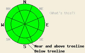
Avalanche danger remains LOW at all elevations and on all aspects. Use normal caution when traveling in the backcountry. |
|
|
|
A dry cold front should move through the region today. This front should be even drier than previously thought and should not bring much in the way of cloud cover to the area. It will however bring cold clear weather and continued moderate to strong northerly winds through tomorrow. Temperatures should reach into the upper 20's to mid 30's above 7000 ft today before they plunge into the the single digits overnight. Tomorrow looks like another clear, cold and breezy day.
Observations on Mt Judah (snowpit) and on Round Top Peak (snowpit and photo) yesterday matched with recent observations across the forecast area. Almost no snow exists on any of the southerly aspects. Faceting has weakened all of the layers in the snowpack to the point that only weak snow remains without a slab on top of it on many of the less exposed NW-N-NE-E aspects. In a few areas, some isolated hard slabs still exist on top of a variety of weak snow; however, logs, stumps, rocks and other anchors hold these slabs in place in most places. Most observations and data point to a stable and shallow snowpack with a few occasional indications of very isolated areas of instability where those hard slabs exist on slopes without good anchors. The snow surface varies from soft weak snow to icy snow left over from last season to wind scoured crusts to hard icy wind slabs.
Avalanche Concerns: Persistent slabs
Due to lack of of slabs sitting on top of the persistent weak layer and anchors holding what slabs do exist in place in most areas, avalanche activity will remain unlikely. Even though the snowpack seems mostly stable, some slopes without many anchors where hard slabs sit on top of weak snow do exist. Isolated pockets of terrain on steep northerly aspects hold the best potential for finding this worrisome combination. Careful observations and slope by slope evaluation can help determine where these rare patches of possible instability may remain. Be aware of any signs of instability including hollow sounding snow, cracking, whumpfing, unstable test results, etc. If any signs of instability do exist, they should trump other factors while making decisions.
Avalanche danger remains LOW at all elevations and on all aspects. Use normal caution when traveling in the backcountry.
| 0600 temperature: | 24-25 deg. F. |
| Max. temperature in the last 24 hours: | 28-36 deg. F. |
| Average wind direction during the last 24 hours: | East northeast |
| Average wind speed during the last 24 hours: | 30-35 mph |
| Maximum wind gust in the last 24 hours: | 69 mph |
| New snowfall in the last 24 hours: | O inches |
| Total snow depth: | 4-20 inches |
For 7000-8000 ft: |
|||
| Wednesday: | Wednesday Night: | Thursday: | |
| Weather: | Sunny | Clear | Sunny |
| Temperatures: | 33-40 deg. F. | 8-15 deg. F. | 27-34 deg. F. |
| Wind direction: | North | Northeast | East |
| Wind speed: | 10-20 mph with gusts to 35 mph increasing to gusts to 45 mph in the afternoon | 15-25 mph with gusts to 45 mph | 10-15 mph with gusts to 35 mph in the morning |
| Expected snowfall: | O in. | O in. | O in. |
For 8000-9000 ft: |
|||
| Wednesday: | Wednesday Night: | Thursday: | |
| Weather: | Sunny | Clear | Sunny |
| Temperatures: | 29-36 deg. F. | 6-13 deg. F. | 25-32 deg. F. |
| Wind direction: | North | Northeast | East shifting to the southeast in the afternoon |
| Wind speed: | 20-30 mph with gusts to 45 mph increasing to 60 mph in the afternoon | 20-30 mph with gusts to 55 mph decreasing to 45 mph after midnight | 15-25 mph with gusts to 40 mph decreasing to 10-15 mph with gusts to 25 mph in the afternoon |
| Expected snowfall: | O in. | O in. | O in. |


This website is owned and maintained by the non-profit arm of the Sierra Avalanche Center. Some of the content is updated by the USDA avalanche forecasters including the forecasts and some observational data. The USDA is not responsible for any advertising, fund-raising events/information, or sponsorship information, or other content not related to the forecasts and the data pertaining to the forecasts.

