In partnership with: 
|
December 30, 2011 at 8:00 am |
|
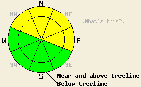
MODERATE avalanche danger exists in snow covered areas on NW-N-NE-E aspects on slopes 37 degrees and steeper. For all other areas, avalanche danger remains LOW. |
|
|
|
A cold front that is expected to pass through the forecast area later this afternoon will bring an end to the warmer air temperatures of the past few days. Until frontal passage occurs, continued warm air temperatures with daytime highs in the 40s are expected for nearly all elevations. Remote sensors around 8,500' across the forecast area are reporting air temperatures this morning at 30 to 40 degrees. The vast majority of locations remain above freezing. In the northern portion of the forecast area, cloud cover has decreased early this morning, allowing for air temperatures to drop below freezing at locations above 8,600'. Precipitation today is expected to occur between 10am and 4pm, prior to the arrival of cold air. Snow level is forecast at 7,000 to 7,500' with most of the the precipitation falling north of Hwy 80. Up to 1 to 2 inches of new snow are possible over the highest terrain. Trace amounts of precipitation are expected for areas south of Hwy 50. Precipitation will end quickly after cold front passage occurs. Nearly all of the rain and snow that falls today will do so with warm air in place. Ridgetop winds are moderate in speed out of the southwest this morning. Wind speed is forecast to increase to gale force by this afternoon with ridgetop gusts to 95 mph. After cold front passage occurs, air temperatures are expected to drop into the teens and 20s overnight. Decreased winds with air temperatures is the 30s and 40s are expected for Saturday.
Observations made yesterday on Andesite Ridge (Donner Summit area) showed continued wet snow with no evidence of an overnight refreeze on all NW-N-NE-E aspects up to the highest elevation traveled around 7,800'. The snowpack was wet from top to bottom. The faceted snow at the base of the snowpack has become cohesive with the increase in moisture. Faceted snow that was once sugar like in consistency will now form into a snowball. The wet snow on the surface was fairly unstable, with several small wet loose avalanches easily skier triggered in open areas below treeline around 7,700' on NE-E aspects on slopes 37 to 42 degrees in slope angle. One small wet loose natural avalanche was noted in this area on a NE aspect, 37 degree slope at 7,700'. (photos, video, more info). On SE-S-SW-W aspects, little to no snow exists across the forecast area.
Avalanche Concerns: Wet loose avalanches
Continued cloud cover for most of last night and above freezing air temperatures are expected to have kept any refreeze of the snowpack from occurring overnight in the vast majority of areas. Human triggered wet loose avalanche activity remains possible today on NW-N-NE-E aspects on slopes 37 degrees and steeper. Isolated natural wet loose avalanches remain possible today, especially in areas where rain falls on snow. Avalanche activity that occurs today is generally expected to be fairly small. Areas where avalanche debris deposit into a terrain trap could create sufficient depth to bury a person.
MODERATE avalanche danger exists in snow covered areas on NW-N-NE-E aspects on slopes 37 degrees and steeper. For all other areas, avalanche danger remains LOW.
| 0600 temperature: | 30 to 40 deg. F. |
| Max. temperature in the last 24 hours: | 35 to 45 deg. F. |
| Average wind direction during the last 24 hours: | Southwest |
| Average wind speed during the last 24 hours: | 24 mph |
| Maximum wind gust in the last 24 hours: | 60 mph |
| New snowfall in the last 24 hours: | O inches |
| Total snow depth: | 3 to 19 inches |
For 7000-8000 ft: |
|||
| Friday: | Friday Night: | Saturday: | |
| Weather: | Mostly cloudy skies with a chance of rain and snow. Snow level 7,000' to 7,500'. | Mostly cloudy skies with a slight chance of snow in the evening. Partly cloudy skies after midnight. | Partly cloudy skies in the morning, becoming mostly cloudy. |
| Temperatures: | 41 to 49 deg. F. | 16 to 23 deg. F. | 36 to 43 deg. F. |
| Wind direction: | SW | SW shifting to W | SW shifting to E |
| Wind speed: | 20 to 35 mph with gusts to 60 mph. Winds increasing to 30 to 45 mph with gusts to 75 mph in the afternoon. | 20 to 30 mph with gusts to 70 mph. Winds decreasing to 10 to 20 mph with gusts to 50 mph after midnight. | 10 to 15 mph with gusts to 30 mph. |
| Expected snowfall: | Trace to 1 in. | 0 to trace in. | O in. |
For 8000-9000 ft: |
|||
| Friday: | Friday Night: | Saturday: | |
| Weather: | Mostly cloudy skies with a chance of snow. | Mostly cloudy skies with a slight chance of snow in the evening. Partly cloudy skies after midnight. | Partly cloudy skies in the morning, becoming mostly cloudy. |
| Temperatures: | 40 to 46 deg. F. | 15 to 22 deg. F. | 38 to 44 deg. F. |
| Wind direction: | SW | W | W shifting to SE |
| Wind speed: | 30 to 45 mph with gusts to 80 mph. Winds increasing to 40 to 60 mph with gusts to 95 mph in the afternoon. | 35 to 50 mph with gusts to 90 mph. Winds decreasing to 30 to 45 mph with gusts to 60 mph after midnight. | 10 to 20 mph with gusts to 45 mph. Gusts decreasing to 30 mph in the afternoon. |
| Expected snowfall: | Trace to 2 in. | 0 to trace in. | O in. |


This website is owned and maintained by the non-profit arm of the Sierra Avalanche Center. Some of the content is updated by the USDA avalanche forecasters including the forecasts and some observational data. The USDA is not responsible for any advertising, fund-raising events/information, or sponsorship information, or other content not related to the forecasts and the data pertaining to the forecasts.

