In partnership with: 
|
January 2, 2012 at 8:00 am |
|
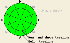
LOW avalanche danger exists on all aspects and at all elevations. Use normal caution when traveling in the backcountry. |
|
|
|
Last month represented one of the driest Decembers on record (more info and some stats from the NWS). So far the New Year has not brought much change. Yesterday, South Lake Tahoe's high of 54 set a new record for Jan. 1st. Last night lows across the region ranged from the 40's around 7000 ft to the mid to upper 30's above 8500 ft. The forecast calls for warm, dry weather to continue across the forecast area this week. A small, weak low pressure system north of the forecast area should cause an increase in the southwest winds, and it could push a few more clouds into the region today. Even though this cloud cover and wind should keep today's highs slightly cooler than yesterday's, expect to see temperatures in the upper 40's and low 50's in the mountains this afternoon. By tonight the clouds should start to disperse, and the winds should begin decreasing allowing overnight lows to drop below freezing. A high pressure ridge should re-establish itself over the region tomorrow keeping skies mostly sunny and daytime highs in the upper 40's and low 50's above 7000 ft.
Observations on Castle Peak yesterday showed that the recent rain and melting affected the snowpack up to at least 9000 ft. A firm, refrozen rain crust three to six inches thick with less than one inch of new snow above it existed on the snow surface on the NW-N-NE-E aspects in this area. Hand pits and snowpit data indicated that free water had percolated all the way through the snowpack. This data also showed that the weak facets once prevalent in the snowpack continue to change into more stable rounded snow grains. Below the surface crust, the snowpack continues to slowly refreeze. Yesterday only the bottom layer of the snowpack still held liquid water. Snowpit tests indicated that this unfrozen layer remained weak (snowpit).
Avalanche Concerns:
The warm and moist weather has helped destroy the weak faceted snow that has plagued the region all season. As the water in the snowpack freezes, the entire snowpack including that once persistent weak layer should become much stronger due to the icy bonds that form within the snowpack. Clear skies last night should have allowed the snowpack to radiate enough heat out into the night for a solid refreeze to occur. Even though the temperatures may climb into the 50's, this refreeze combined with the weak winter sun should prevent much melting from occurring on the northerly slopes where snow exists. Avalanche activity should remain unlikely. A few rare and very isolated patches of snowpack instability may still exist on slopes where the snowpack has not refrozen all the way or on the highest-elevation, un-anchored northerly aspects where warming has not destroyed the facets. Travel with caution in the backcountry.
LOW avalanche danger exists on all aspects and at all elevations. Use normal caution when traveling in the backcountry.
| 0600 temperature: | 34-38 deg. F. |
| Max. temperature in the last 24 hours: | 47-53 deg. F. |
| Average wind direction during the last 24 hours: | Southwest |
| Average wind speed during the last 24 hours: | 20 mph |
| Maximum wind gust in the last 24 hours: | 56 mph |
| New snowfall in the last 24 hours: | O inches |
| Total snow depth: | 2-18 inches |
For 7000-8000 ft: |
|||
| Monday: | Monday Night: | Tuesday: | |
| Weather: | Mostly cloudy | Partly cloudy | Partly cloudy |
| Temperatures: | 44-51 deg. F. | 28-34 deg. F. | 42-52 deg. F. |
| Wind direction: | Southwest | Southwest | Southwest |
| Wind speed: | 10-15 mph with gusts to 35 mph | 10-15 mph with gusts to 30 mph | 10-15 mph in the morning becoming light in the afternoon |
| Expected snowfall: | O in. | O in. | O in. |
For 8000-9000 ft: |
|||
| Monday: | Monday Night: | Tuesday: | |
| Weather: | Mostly cloudy | Partly cloudy | Partly cloudy |
| Temperatures: | 45-51 deg. F. | 26-33 deg. F. | 43-50 deg. F. |
| Wind direction: | Southwest | Southwest | Southwest |
| Wind speed: | 15-25 mph with gusts to 50 mph | 15-25 mph with gusts to 45 mph | 10-15 mph with gusts to 35 mph in the morning |
| Expected snowfall: | O in. | O in. | O in. |


This website is owned and maintained by the non-profit arm of the Sierra Avalanche Center. Some of the content is updated by the USDA avalanche forecasters including the forecasts and some observational data. The USDA is not responsible for any advertising, fund-raising events/information, or sponsorship information, or other content not related to the forecasts and the data pertaining to the forecasts.

