In partnership with: 
|
January 7, 2012 at 7:59 am |
|
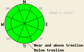
LOW avalanche danger exists for all elevations and aspects. Use normal caution in the backcountry. |
|
|
|
Cold, clear weather and north to northeast winds have moved into the forecast area behind a cold front that passed by the region over the last 24 hours. The winds should continue to increase today with gusts along the ridges reaching into the 65 mph range. The forecast calls for daytime highs in the upper 20's and mid 30's above 7000 ft. today. The winds should remain strong through tonight before they start decreasing tomorrow afternoon as the high pressure ridge rebuilds over the region. Tomorrow's high temperatures should climb back up into the upper 30's to mid 40's across the forecast area.
Observations along the Sierra Crest near Tinker's Knob showed a variable snowpack with a mix of rain crusts, ice layers, weak sugary facets, and stronger snow grains (photos). On a N facing aspect near 8200 ft, a thin layer of weak facets had reformed underneath the Dec. 28-29 rain crust (photo). In this same area, another layer of weak snow existed near the ground. One snowpit test showed that fractures could travel along this weak bottom layer while the same test done nearby showed that this layer remains difficult to break (snowpit). Other observations since the rain event on Dec. 28-29 across the forecast area have shown a mostly stable snowpack that continues to gain strength. In the areas where less rain fell (mostly south of Barker Pass and on the east side of the Lake), some weaker facets still remain underneath the rain / melt freeze surface crusts. Luckily less snow exists, and more anchors protrude through the snowpack in these areas. Above 9000 ft where less rain and warming have occurred strong north and easterly winds earlier this fall and winter have scoured most of the snow away from these once worrisome starting zones.
Avalanche Concerns:
Avalanche activity remains unlikely. In most places the spring-like weather has allowed the once persistent weak layer to gain strength. In the areas it still remains, enough anchors extend through the snowpack to keep what snow exists in place. In some areas the recent cold, clear nights and colder days will allow weakness to reform in the snowpack. This process could quickly recreate a weak layer that may pose problems down the road. Even though the avalanche danger remains low, plenty of other hazards like icy slopes with rocks and trees at the bottom exist. Continue to use caution when traveling in the backcountry.
LOW avalanche danger exists for all elevations and aspects. Use normal caution in the backcountry.
| 0600 temperature: | 18-22 deg. F. |
| Max. temperature in the last 24 hours: | 38-45 deg. F. |
| Average wind direction during the last 24 hours: | Southwest shifting to the Northeast |
| Average wind speed during the last 24 hours: | 15-20 mph |
| Maximum wind gust in the last 24 hours: | 45 mph |
| New snowfall in the last 24 hours: | O inches |
| Total snow depth: | 0-18 inches |
For 7000-8000 ft: |
|||
| Saturday: | Saturday Night: | Sunday: | |
| Weather: | Sunny | Clear | Sunny |
| Temperatures: | 32-38 deg. F. | 22-28 deg. F. | 40-45 deg. F. |
| Wind direction: | North shifting to the northeast this afternoon | East | East |
| Wind speed: | 10-20 mph with gusts to to 45 mph | 10-20 mph with gusts to 40 mph | 10-20 mph with gusts to 40 mph decreasing to around 5-10 mph with gusts to 25 mph in the afternoon |
| Expected snowfall: | O in. | O in. | O in. |
For 8000-9000 ft: |
|||
| Saturday: | Saturday Night: | Sunday: | |
| Weather: | Sunny | Clear | Sunny |
| Temperatures: | 26-33 deg. F. | 20-25 deg. F. | 36-42 deg. F. |
| Wind direction: | North shifting to the northeast this afternoon | East | East |
| Wind speed: | 25-35 mph with gusts to 55 mph increasing to 30-45 mph with gusts to 65 mph in the afternoon | 30-45 mph with gusts to 65 mph | 20-35 mph with gusts to 55 mph decreasing to 10-15 mph with gusts to 30 mph in the afternoon |
| Expected snowfall: | O in. | O in. | O in. |


This website is owned and maintained by the non-profit arm of the Sierra Avalanche Center. Some of the content is updated by the USDA avalanche forecasters including the forecasts and some observational data. The USDA is not responsible for any advertising, fund-raising events/information, or sponsorship information, or other content not related to the forecasts and the data pertaining to the forecasts.

