In partnership with: 
|
January 8, 2012 at 7:50 am |
|
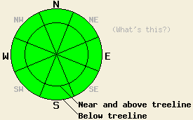
LOW avalanche danger exists for all elevations and aspects. Use normal caution in the backcountry. |
|
|
|
Spring-like weather should return to the forecast area today as a high pressure ridge rebuilds over the region. The north and east winds should decrease today, and by tomorrow winds should become light at all elevations. Temperatures should also climb back into the low to mid 40's above 7000 ft today with even warmer daytime highs forecasted for tomorrow. A few high, thin clouds may linger over the forecast area during the day today, but these should disperse by this afternoon and evening leaving skies clear for tonight and tomorrow.
A highly variable snowpack exists across the forecast area. Observations since the rain event on Dec. 28-29 area have shown a mostly stable snowpack with thick, strong melt-freeze layers and rain crusts holding everything together. In the areas where less rain fell (mostly south of Barker Pass, on the east side of the Lake, and at the higher elevations), some weaker facets still remain underneath the rain / melt freeze surface crusts. Luckily less snow exists, and more anchors protrude through the snowpack in these areas. Above 9000 ft where less rain and warming have occurred strong north and easterly winds earlier this fall and winter have scoured most of the snow away from these once worrisome starting zones. Yesterday on Round Top Peak and around Carson Pass, very little snow existed below 9000 ft. Above 9000 ft on the northerly aspects, patchy snow coverage existed mostly due a lack of snowfall and the wind scouring mentioned above. The largest snow patches consisted of very dense, icy snow left over from last year. In some of the more sheltered areas, the snowpack consisted of a thick, strong hard slab with weaker snow below it. Snowpit tests in these areas indicated that fractures can travel through this weak layer; however, starting such a fracture remains difficult.
Avalanche Concerns:
Avalanche activity remains unlikely. In most places the persistent weak layer that plagued the area for most of the season has gained strength due to the recent rain and warmer weather. In the areas it still remains, enough anchors extend through the snowpack to keep the snow that exists in place. The recent cold, clear nights and colder days have allowed some weakness to reform in the snowpack; however, these weaknesses remain isolated and dispersed in nature. If they continue to grow, they could create weak layers that may pose problems later on. Even though the avalanche danger remains low, plenty of other hazards like icy slopes with rocks and trees at the bottom exist. Continue to use caution when traveling in the backcountry.
LOW avalanche danger exists for all elevations and aspects. Use normal caution in the backcountry.
| 0600 temperature: | 26-34 deg. F. |
| Max. temperature in the last 24 hours: | 28-34 deg. F. |
| Average wind direction during the last 24 hours: | Northeast |
| Average wind speed during the last 24 hours: | 48 mph |
| Maximum wind gust in the last 24 hours: | 77 mph |
| New snowfall in the last 24 hours: | O inches |
| Total snow depth: | 0-18 inches |
For 7000-8000 ft: |
|||
| Sunday: | Sunday Night: | Monday: | |
| Weather: | Mostly sunny | Clear | Sunny |
| Temperatures: | 40-45 deg. F. | 26-33 deg. F. | 45-50 deg. F. |
| Wind direction: | East | Southeast | South |
| Wind speed: | 10-15 mph with gusts to 30 mph decreasing in the afternoon | up to 10 mph | up to 10 mph |
| Expected snowfall: | O in. | O in. | O in. |
For 8000-9000 ft: |
|||
| Sunday: | Sunday Night: | Monday: | |
| Weather: | Mostly sunny | Clear | Sunny |
| Temperatures: | 37-44 deg. F. | 28-33 deg. F. | 40-46 deg. F. |
| Wind direction: | East | East | Southwest |
| Wind speed: | 15-25 mph with gusts to 50 mph in the morning decreasing to 10 -15 mph with gusts to 35 mph | 10-15 mph with gusts to 30 mph | around 10 mph |
| Expected snowfall: | O in. | O in. | O in. |


This website is owned and maintained by the non-profit arm of the Sierra Avalanche Center. Some of the content is updated by the USDA avalanche forecasters including the forecasts and some observational data. The USDA is not responsible for any advertising, fund-raising events/information, or sponsorship information, or other content not related to the forecasts and the data pertaining to the forecasts.

